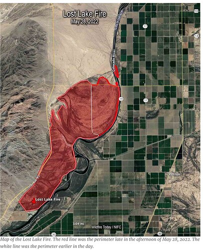
Any updates on acres and closures? I’m 10 miles south of this fire in a small community on the river.
KESQ has some info, reporting 1000 acres with ongoing evac orders in place.
This looks like the AZ-CRA-000528 Lost Lake fire.
The SWCC has info in their morning report, updated to 1000 acres:
https://gacc.nifc.gov/swcc/predictive/intelligence/daily/SWCC_Morning_Situation_Report/SWCC_Morning_Situation_Report.htm
Lost Lake BIA - Colorado River Agency. Started 05/26/22. Undetermined Cause. Lost Lake Resort - Hidden Valley Resort.
- 80 acres . Primary Fuel Model: Chaparral (6 feet). SUPPRESSION strategy (100% Full Suppression). Currently 0% contained - anticipating containment 05/31/22. Moderate fire behavior (Crowning). Projected Activity: Continued spread to the south & north.
- Structures Threatened: 200; Damaged: None; Destroyed: None
- Resources Assigned: None reported.
- Critical Resource Needs: Dozers/Heavy Equip
- Type 3 IC - Benji Stewart
- Report Submitted: - 05/26/2022-21:42
- Incident Notes: Updated this morning to show 1000 acres.
IA thread is in the Southwest since it belongs to the Southwest Coordination Center:
https://forums.wildfireintel.org/t/az-cra-lost-lake/
Yes I started a thread yesterday under SW initial attacks
Any resources from BDC assigned?
It has been updated to the most current jurisdiction.
Media saying 4700 acres. Definitely a overgrown mess out there
The scoopers that came from Santa Fe had a nice evening in bullhead city. Just to fly back to Santa Fe this morning…. Really makes you shake your head as a tax payer.
Any word of a team?? Lol had too…
Central West Zone, type 3 team ordered
Planned Actions
Fire personnel will work to secure a perimeter around the fire and the communities of Lost Lake and Hidden Valley Resorts.
Firefighters continue to work to stop the forward spread of the fire. The fire remains on the California side of the Colorado River and fire personnel will work today to keep it from spreading to Arizona.
Central West Zone Type 3 Incident Management Team has been ordered.
https://maps.nwcg.gov/sa/#/%3F/33.993/-114.481/10
gives modis and viirs heat signatures and location on map
How is this an AZ incident?? It’s in CA.
might I suggest you look at gnufsh’s comments earlier.
AZ-CRA is the jurisdictional agency and belongs in the Southwest GACC. Just like there are NV-HTF (Great Basin) fires in CA and CA-INF fires in NV. The GACC boundaries, dispatch boundaries, and federal agency boundaries don’t exactly follow state lines. IROC, IRWIN, Wildweb/WIldcad, the ICS-209 Program, etc all reflect the agency as AZ-CRA. You can’t just change the state part, because the 3 letters are not unique nationally (eg CA-CNF and AZ-CNF are two different forests).
Affirmative
They just updated Inciweb again
Size: 5,465 Acres
Contained: 34%
From Inciweb 5 minutes ago
5,727 Acres
Contained: 47%
AZ-CRA #LostLakeFire Update: 5,727 acres and 47% contained
Firefighters have stopped the fire’s progression and are improving containment lines.
All evacuations have been lifted and power restored to fire area. More info on @Inciweb: https://inciweb.nwcg.gov/incident/8122/
#AZFire #CAFire https://twitter.com/wildlandfireAZ/status/1531314317840162816/photo/1

