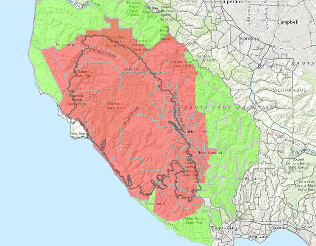
Visibility is very poor today over the south end of the fire. Normally we can see the mountains above Felton and Ben Lomond from basecamp but they are totally obscured today.
San Mateo Sheriffs office just announced lifting of many evacuation areas unaffected by the fire on the North side of the fire. Check the evac map for recent clearances:
Pescadero, La Honda, Skylonda, Middleton tract, Portola Heights…
https://www.smcgov.org/smc-wildfire-response
Summary of last night and this am briefings.
81,333 acres
21% contained
646 structures identified as destroyed, 11 in San Mateo Co. 635 in Santa Cruz Co.
Of that total, 445 were residences, 1 multiple family residence, 50 non-residential commercial, and another 150 were other minor structures such as sheds, barns garages, etc. An additional 46 residences damaged, 7 non-residential commercial damaged, 16 other minor structures damaged.
Damage Assessment Team survey is about 55% complete. Many areas have not yet been inspected and work to post info on the website continues.
1982 personnel are now assigned to the fire. New crews continue to report in to the fire and are being put to work.
The firelines in the North Zone continue to hold well. They are patrolling and monitoring areas in Div G and Div K and the Pescadero area.
Butano has fire still creeping slowly down towards the control lines and firefighters are waiting for favorable ground to fight the fire on. Coastal weather continues to mitigate fire activity in that area.
Work in Davenport continues to rebuild the powerlines and get power restored to that area. Lots of PG& E crews working in the area. There is good black line along the west side of the fire and work continues with Cal Trans and utilities to get the Hwy 1 route open.
UCSC started a re-population plan yesterday and fire commanders are confident that the lines on the south will withstand any north winds expected this weekend.
Line around Felton is 3/4 complete, yesterdays burn op was delayed. The fog stuck around too long yesterday and they could not get the fire to burn effectively enough to make a good black line in the areas they wanted until much later in the afternoon. Also, one of the “highly qualified” personnel Chief Brunton spoke about yesterday who would be leading the burning operation had his vehicle broken into and his fire safety gear was stolen out of his vehicle. He was able to get replacement gear and was back on the fireline yesterday, but it was also a disruption to the plan.
Aircraft was not as active yesterday due to weather conditions. only 10,000 gallons of water dropped.
Hwy 236 area and Bonny Doon area roadways are still getting cleared for crews to gain access. There are a lot of damaged trees in the area.
Law Enforcement - They have gone 4 days without new arrests, they will have 42 officers on patrol today, 21 from Santa Cruz Co. 14 from cooperating agencies and 7 from “over the hill”. Law enforcement officers conducted 10 welfare checks, responded to 3 reports of suspicious people and assisted Animal Services with over 100 requests to feed/check on animals left in the area.
Last night’s briefing mentioned that they found the 73 year old man who had been reported missing by a friend after he left safety on Monday and tried to re-enter the evacuation area. He had found a trail on the outskirts of the area and attempted to hike back in and got lost. He spent 2 nights in the woods and was discovered by a search and rescue effort in a very steep area. It required 126 man hours, 3 hours of ambulance time and a helicopter to find him and lift him out. One of the searchers (on mountain bike) was injured in the process. He is going to be okay, but this diverted all kinds of resources to find him and help him. He was taken for treatment and issued a citation. 2 other missing people mentioned at yesterdays briefing have been located and they are okay.
When asked about timelines for evacuations being lifted, the Santa Cruz County Sheriff’s rep stated that will depend on the restoration of safe roads (hazard trees) and utilities to the area. He estimated that in coordination with fire managers, the time line for:
- Scotts Valley could be a day or few days
- Felton could be days to a week
- Further north up Hwy 9 could be a week to weeks, due to much more fire damage in the area, and much more difficult area which slows progress and makes it difficult to work.
- Bonny Doon could be weeks due to the amount of damage and blocked roads, unsafe trees etc.
- the Last Chance area is even more work.
Santa Cruz Sheriff’s rep said pay attention to the online map, the phased plan to reopen will be announced in advance, you will have time to prepare and it is not productive to come to the evacuation barriers and try to wait there to get in. Law Enforcement will be maintaining a high presence in the area even after the evacuations are lifted to ensure your property safe throughout the repopulation process. He also said there is no system for police escorts in or passes to allow people to check their properties, due to ongoing work by utility crews and emergency crews in the area. People are NOT being allowed in to visit their properties and leave again.
San Mateo County Sheriff announced many areas North of the fire in San Mateo County which were unaffected by the fire have had evacuations lifted this afternoon (Sky Londa, La Honda, Portola Heights, Middleton Tract, Pescadero …etc) Areas in the fire zone remain closed. See San Mateo County evac website in separate post.
Links to Santa Cruz Evac maps & Damage maps:
https://www.co.santa-cruz.ca.us/fireresources.aspx
or
www.smco.community.zonehaven.com
Scotts Valley evacs lifted
Aug 28, am press update:
82,540 acres
26% contained
799 structures identified as destroyed (11 San Mateo Co / 788 Santa Cruz Co)
of those, 554 are single family residences.
2019 personnel assigned.
- 30 acre slop over in Brookdale area yesterday, attributed to creeping fire in thick duff.
- discovering lots of weakened trees in residential areas affected by fire, lots of problems on Hwy1 with rolling material. One house (unoccupied) in Butano area destroyed yesterday by a falling tree. “days and days” of tedious restoration work remains. Hwy236 “is a mess” and will require a lot of work just to get the road cleared.
- CNG crews arrived on the fire yesterday which will allow more qualified crews to shift to hazard areas while CNG works griding & hotspots.
- pipe bomb discovered by firefighter in a residential area doing mopup yesterday was destroyed in place by Santa Cruz Co bomb team, investigation continues.
- looking at lifting evacs for more areas unaffected by the fire as warranted by conditions. Pay attention to webpage and social media accounts for latest updates.
- Watershed response team work beginning.
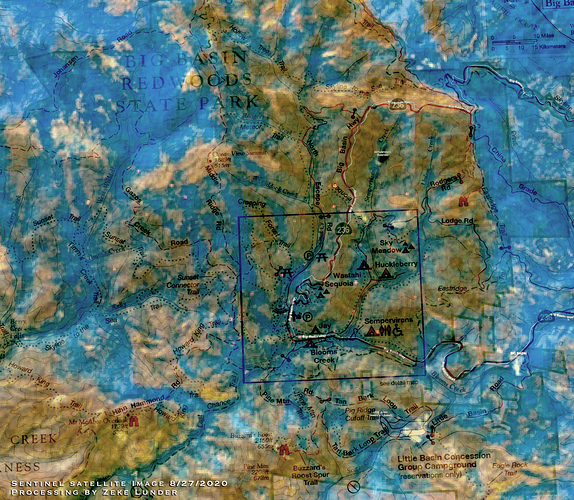
We got an orbit from the Sentinel satellite yesterday, and there was a cloud and fog-free zone over Big Basin Redwoods. I made this image to show the fire severity. It’s not authoritative or vetted on the ground, but these sensors do a pretty good job of capturing what is foliage vs burnt sticks.
Brown and tan areas are devoid of vegetation, lighter shades of tan have a higher severity burn. Some of the lighter tan areas in the image were brush fields before the fire. Blue areas still have foliage. Lighter blue shows more vigorous vegetation.
This image shows that the forest canopy is still intact in large areas of the park. As is typical of most fires, the canyon-bottom areas, which are moister and more sheltered from the wind, appear to have experienced lower-severity fire, while the exposed, hotter and drier ridges had hotter fires.
Thanks for that insight Zeke🤙🏽
Love Big Basin.
84,338 Acres
33% containment
9,374 Structures threatened
1,094 Structures damaged -20 in San Mateo County
2,142 Fire personnel
Evacs lifted in additional areas.
Word at the camp today is the team will transition to the local unit next Wednesday Plan is to keep either 300 or 500 personal (heard both numbers today) and us in Supply could be there until the beginning of October.


