CA-LAC-Eaton ???

Fire will be impacting New York drive shortly.

2 Likes

Nature structure protection group leaving due to heavy fire at the nature center. Fire front following now .

Ordering 20 additional engines any type

4 Likes

IC ordering additional 20 engines any type.
IC ordering 10 strike teams any type, not sure if those 20 engines are included in that 10 strike teams or in addition too.

Edit: IC ordering 20 engines any type closest. Ordering 10 type 1 strike teams.

5 Likes

IC just requested 10 strike teams immediate need.

ANF/LAC going into unified command.

Manifest no new starts…

4 Likes

https://wrcc.dri.edu/cgi-bin/rawMAIN.pl?caCHEN
1900 Update: Max Gust 85mph (!)

2 Likes

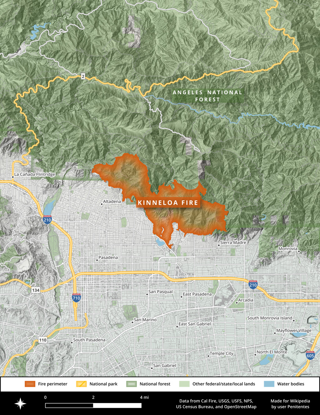
This fire is starting in the same location and taking the same path as the October 1993 Kinneloa Fire. That one was under the influence of the Santa Anas and destroyed dozens of homes on Kinneloa Mesa; burned ~5,500 acres. History doesn’t repeat, but it rhymes!

5 Likes

200+ acres per ANF

2 Likes

Fire is 200 acres per WD

1 Like

Arcadia cam showing a new start.

image

2 Likes

HELCO returning to base due to winds.

Ops advising, “we are in life safety mode, do not anchor in.”

5 Likes

Requesting Law Enforcement, unit reporting people attempting to steal things.

5 Likes

I worked the Kinneloa in '93. Steep and went up to Mt Wilson. Not fun either. Little Santa Anita Canyon was the left flank line.

4 Likes

Between this fire and the Palisades Fire, this January will live in infamy…

9 Likes

Ordering additional 3rd alarm brush.

Ordering 10 type 1 strike teams, but again not sure if thats in addition to the original order for 10.

5 Likes

Did I just here him say nada structure defense?

5 Likes

Looks like it will also be getting an FMAG.

Spot Forecast for Eaton FMAG…LACoFD
National Weather Service Los Angeles/Oxnard CA
706 PM PST Tue Jan 7 2025

If conditions become unrepresentative, contact the National Weather
Service.

…RED FLAG WARNING IN EFFECT UNTIL 6 PM PST THURSDAY…
…HIGH WIND WARNING IN EFFECT UNTIL 6 PM PST WEDNESDAY…
…FIRE WEATHER WATCH IN EFFECT FROM THURSDAY EVENING THROUGH
FRIDAY AFTERNOON…

.DISCUSSION…
Strong and gusty winds will affect the fire area tonight through
most of Wednesday afternoon, finally decreasing some after around
1400 hours. The north to northeast winds will see gusts up to 30 mph
at eye level, with gusts as strong as 80 over the ridges. Winds
will shift direction slightly to become northeast on Wednesday and
remain strong until the mid to late afternoon hours. Overnight
humidity recoveries are expected to be poor, between 20 to 25 percent
but there is a 30% chance of recoveries up to around 30 percent.
Very low humidities in the single digits are expected Wednesday.

.TONIGHT…

Sky/weather…Mostly clear (0-10 percent).
Min temperature…51-53.
Max humidity…20-25 percent.
Eye level wind…North to northeast winds 15 to 18 mph with gusts
25 to 30 mph.
Wind (20 ft)…Very windy. North to northeast winds 30 to 35 mph with
gusts 50 to 60 mph.
Ridgetop wind…North winds 45 to 55 mph with gusts 70 to 80 mph.
Mixing height…4800 ft AGL becoming 1500 ft AGL overnight.
Transport wind…North to northeast 45 mph decreasing to 30 mph.

.WEDNESDAY…

Sky/weather…Sunny (10-20 percent).
Max temperature…69-72.
Min humidity…7 to 9 percent.
Eye level wind…Northeast winds 17 to 22 mph with gusts to 30
mph decreasing to 10 to 12 mph with gusts to 17
mph after 1400.
Wind (20 ft)…Very windy. Northeast winds 35 to 45 mph with
gusts to around 60 mph decreasing to 20 to 25
mph with gusts to 35 mph late in the afternoon.
Ridgetop wind…Northeast winds 40 to 50 mph with gusts to 75
mph decreasing to 20 to 30 mph with gusts to 40
mph in the afternoon.
Mixing height…1400 ft AGL rising to 4500 ft AGL.
Transport wind…Northeast 25 to 30 mph.

3 Likes

Yes you did

2 Likes

ABC7 live ground feeds showing structures beginning to burn.

3 Likes

Well I guess that sums up what I’m hearing over the radio right now.

3 Likes

Shortened Veranada for comm simplicity

2 Likes