
Blew up again today: www.rntl.net/clearlake.htm
They’ve been conducting some large burn operations using aerial ignition. The plan was to continue to fire some key sections of line if they could finish some critical dozers line first. Not sure if that happened or not. Aircraft have not been flying the last few days until the smoke cleared out in the afternoon.
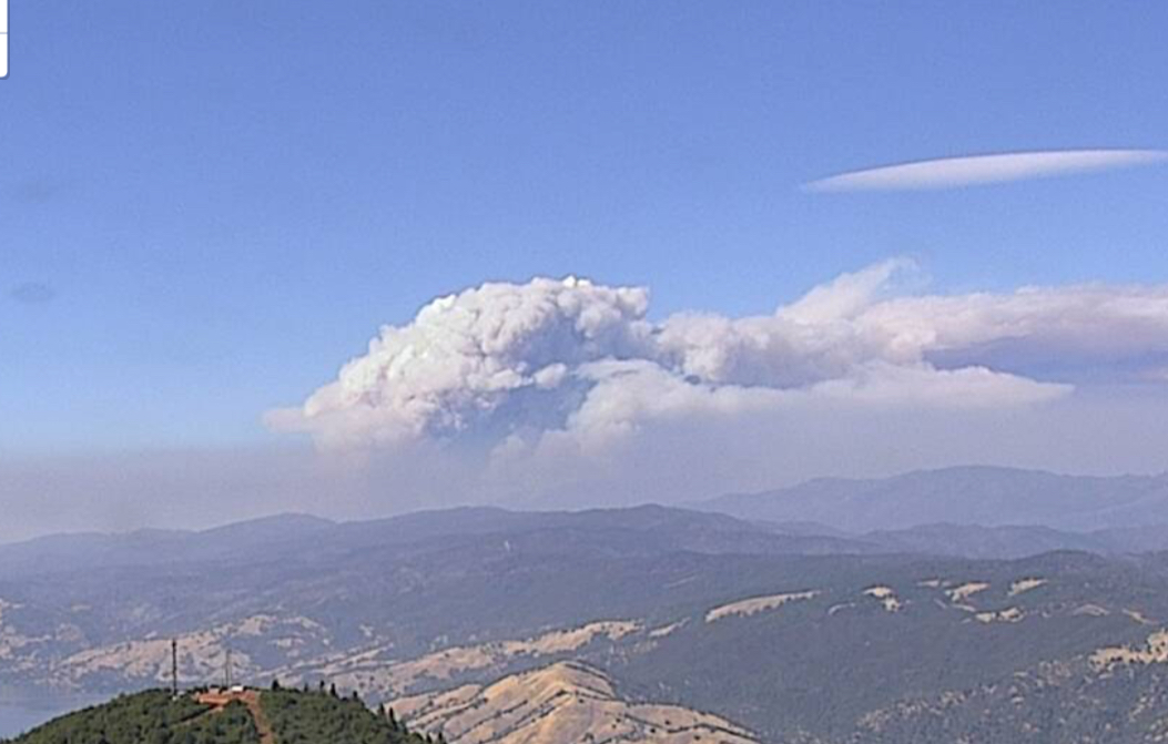
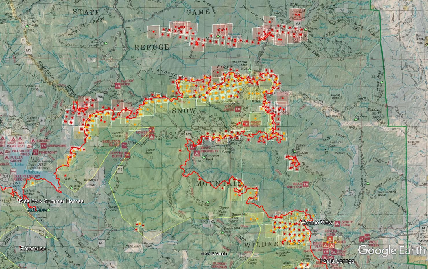
Inversion lifted yesterday and it was off to the races. Still churning this morning as soon as sun rose and lit up those north and eastern slopes and right down the middle fork Stony Creek canyon. Both “heads” of this thing have merged, the piece that originally jumped the Eel at Bear Mtn and went up the Eel River and M3, and the eastern piece that burned up and over Snow Mtn. That creates a lot of unburned island to cook off. The eastern side has spotted north across the middle fork of Stony Creek right below Crockett Peak. Western side will be approaching Div F’s grand stand at Cabbage Patch where the M1 and M6 meet up. Their primary dozer line to flank this thing is Cabbage Patch down to the lake through Big Squaw Valley to near Lakeshore trailhead.
11 Likes
Large firing operation on the top of St John Mtn and the radio sites up there. The 2001 Trough Fire burned up the AC line that went up to the top and it was never replaced. If I recall some of it was even buried and it still got damaged by dozers and engines. The entire site now runs off solar and propane.
1 Like
Per the incident report to NorthOps “critical resources are timing out, if unable to obtain engines and crews success of current containment lines will be marginal and result in next planning area adding over 100,000 acres”
2 Likes
Pretty significant afternoon and evening on the fire today. Extreme fire behavior on all fronts, some spotting over the Eel River Road this afternoon but they picked them up, nothing bigger than half an acre. They lost everything on the NE side in Div H and J. Sounds like they were trying to hold it in the bowl of Cold Creek and DP25 area but lost it. Probably a little more direct than they should have been in there, fire blew up hard and right through DP25 and well established now in The Pocket and pushing more NE. All resources accounted for and pulled off DP25 in J up to DP26.
Now there is lots of talk of getting heavy contingency on the SRA which will be TGU and Elk Creek. Pretty crazy to think about the scale of this. Coupled with the incident report mentioned above from SmokeyPack, we’re at a significant juncture here. There is no IR flight tonight due to mechanical so no updated mapping at a crucial time where we had a huge push. Thinking outside the box, not sure why they can’t utilize Natl Guard drone or even CHP Fixed Wing. CHP was amazing resource on the Atlas and related fires in Sonoma/Napa, flying night air attack basically providing intel to the ground on fire front location at night. A fly over could help get an accurate perimeter to build their map for tomorrow at least in those divisions. (armchair qb’ing sorry)
GOES satellite says a lot this afternoon and evening. Scroll through the afternoon and evening for Natural Color Fire, as well as Shortwave IR. I haven’t seen those signatures well into the night since very early in the incident.
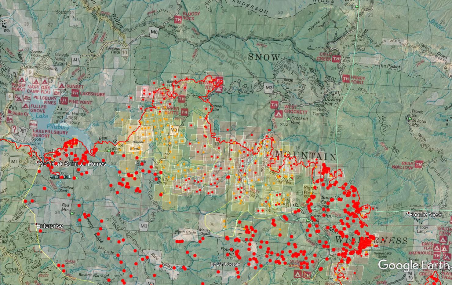
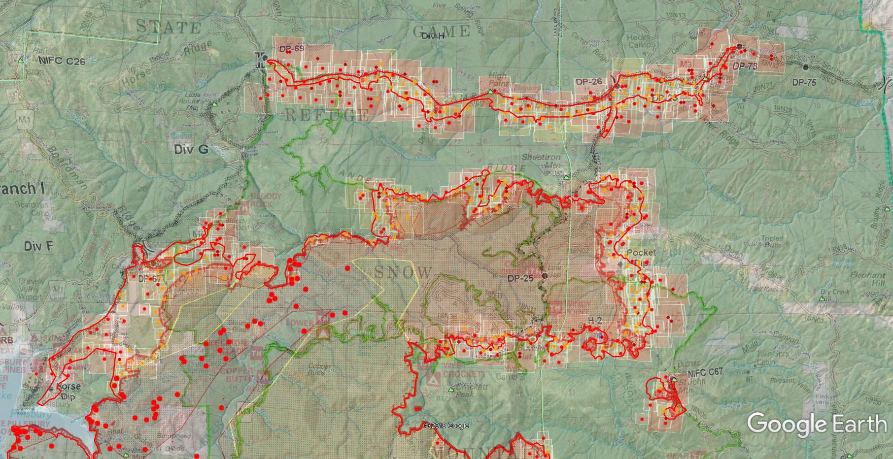
Attached is the latest MODIS, which is current from early afternoon only, on top of an Ops Map from the 13th for the Div/Branch/Drop Point references, so ignore the red perimeter line, last night’s IR perimeter is the yellow line. (IR could even be from Friday night, my IR comes from NIROPS and not from the incident kmz and the NIROPS data is a bit more than the latest IR kmz from the incident, which states last night and tonight will be Unable To Fill.) You can see the firing ops from earlier in the day around NIFC C67, which is St. John Mtn. I have no intel on what’s happening in the Fouts Springs area and Div Kilo/Lima, if that is good fire or what’s going on.
7 Likes
Is NIROPS “Aircraft 3” (other national technical means) unavailable? This asset would be fine for this problem.
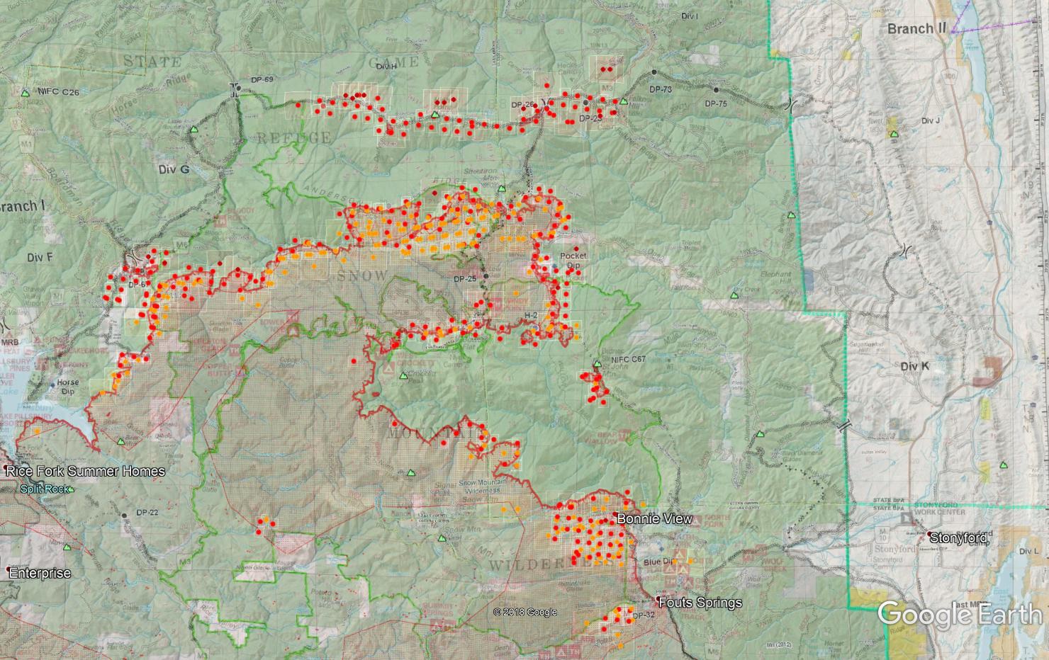
MODIS/VIIRS hits from this morning over the last 24 hours. This shows the big push north and east over Div J and Sheetiron Mtn.
3 Likes
Mandatory Evacuation notice in Glenn County
The evacuation order includes all areas: North of Glenn-Colusa County Line, east of the Mendocino National Forest boundary, south of County Road 308, and west of County Road 306.
1 Like
Some firing ops planned for today. Sounds like F and G are prepping and hoping to fire as soon as conditions are appropriate. The really want to hold Div H today. They want to take fire from DP26 west to High Point along the line and southern slope with aerial ignition. They were hoping to get as much fixed wing as possible to pretreat the line and back slope but visibility is limited for that. There would be nobody ahead of it if firing took place. They understand it’s low probability of success but they understand the fire will reach the area today sometime anyway, and the expected westerly wind push this afternoon will make a lot of runs right up to the line. We’ll see if that folds out.
Expecting a marine influence this evening into the rest of the week cooling things down a bit and bringing up RH in some places, but with that comes the afternoon winds out of the west pushing this further toward the SRA and Elk Creek area. A lot of the terrain on the north end is east-west aligned which will go right with the winds.
6 Likes
Commencing firing ops at DP-26, working both east and west of DP26 on the dozer line along Brushy Camp Ridge. Smith River and Plumas IHC will work through the night. Let’s hope for a win here and stop this thing from pushing north.
Div J and Pocket Dip has had some copter work throughout the day, some structure protection around The Pocket area. Scoopers were approved out of Stony Gorge Reservoir but they got snagged by STF-Donnell when they tried making it earlier but couldn’t get through the smoke.
Div F and G are getting in sync with their ops. They’re holding existing fire in check and then will start assessing firing ops approx 1800 tonight if conditions are favorable. They would be firing from DP-67 (the F/G break) both northeast towards Bloody Rock, and south into Squaw Valley.
5 Likes
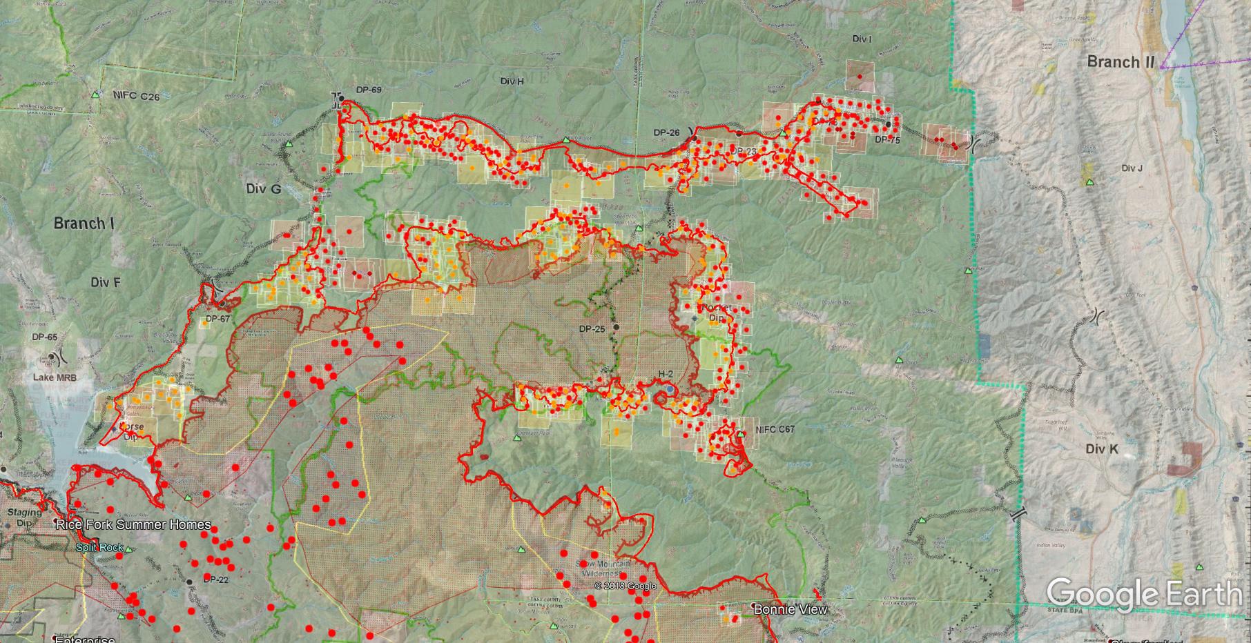
Looking good this morning! IR flight was early, around 930pm so the firing ops had just gotten underway. The MODIS/VIIRS hits this morning help complete the picture of what appears to be a LOT of great work firing Brushy Camp Ridge out on Div H, as well as the dozer lines in Div F.
MODIS/VIIRS as of 0700 8/21 over the Forest Map
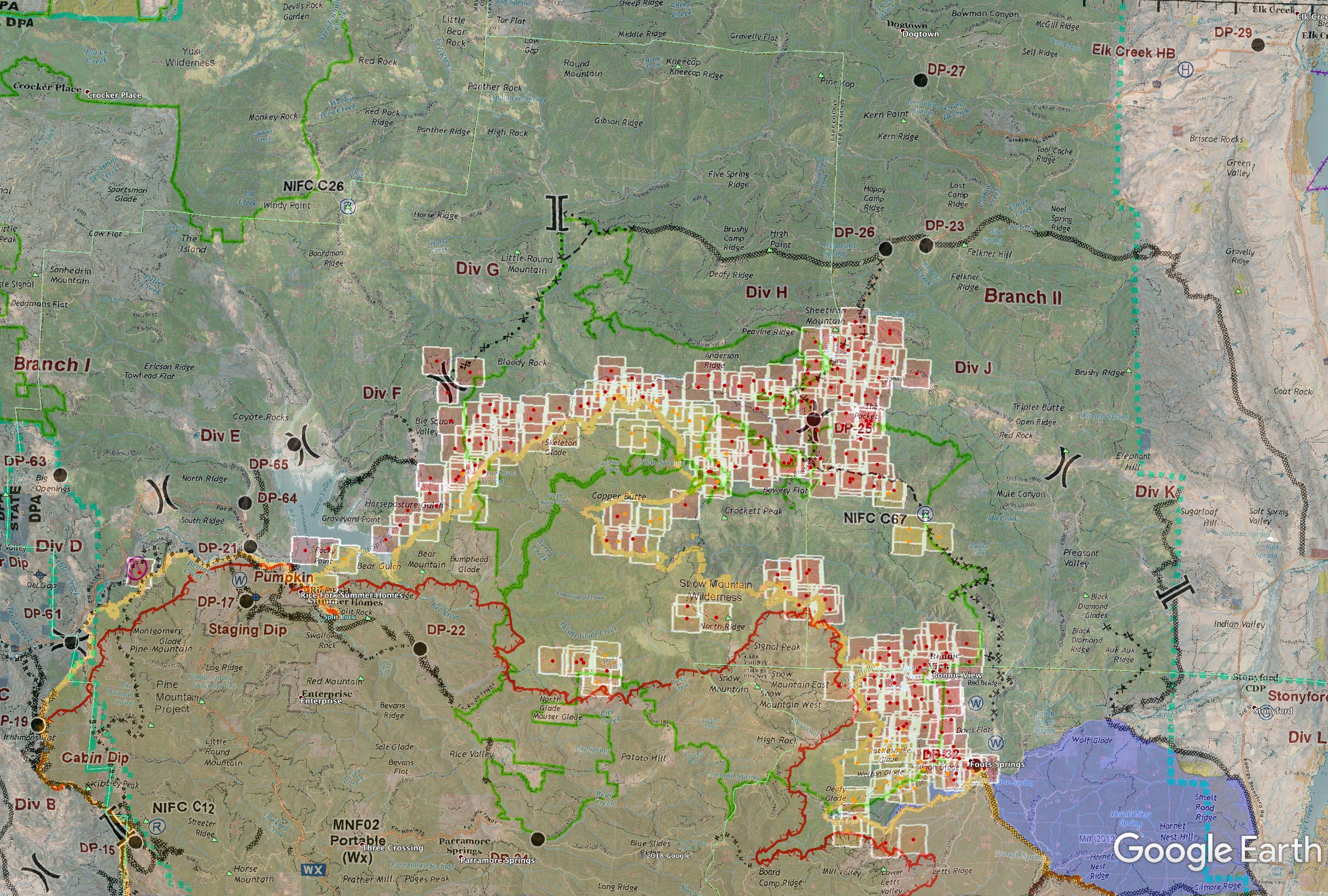
Here’s today’s Ops map focused on the northern Branch I and II, with MODIS/VIIRS hits as of 0700 08/21 on top of it.
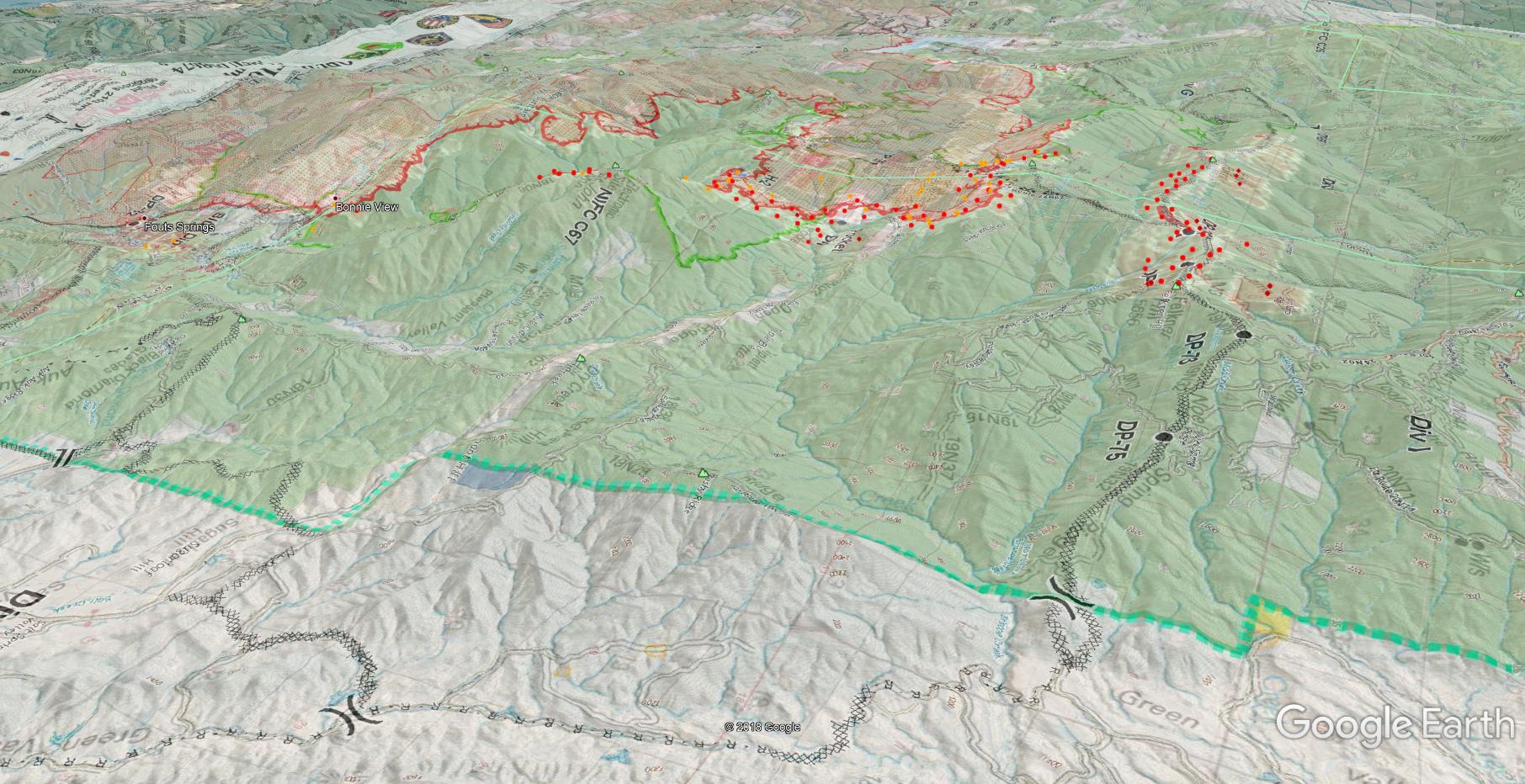
Looking SW from over Div K, right at St. John, showing the terrain over the open country between perimeter and the dozer line and some of the east-west alignment in Anderson Creek below the firing op.
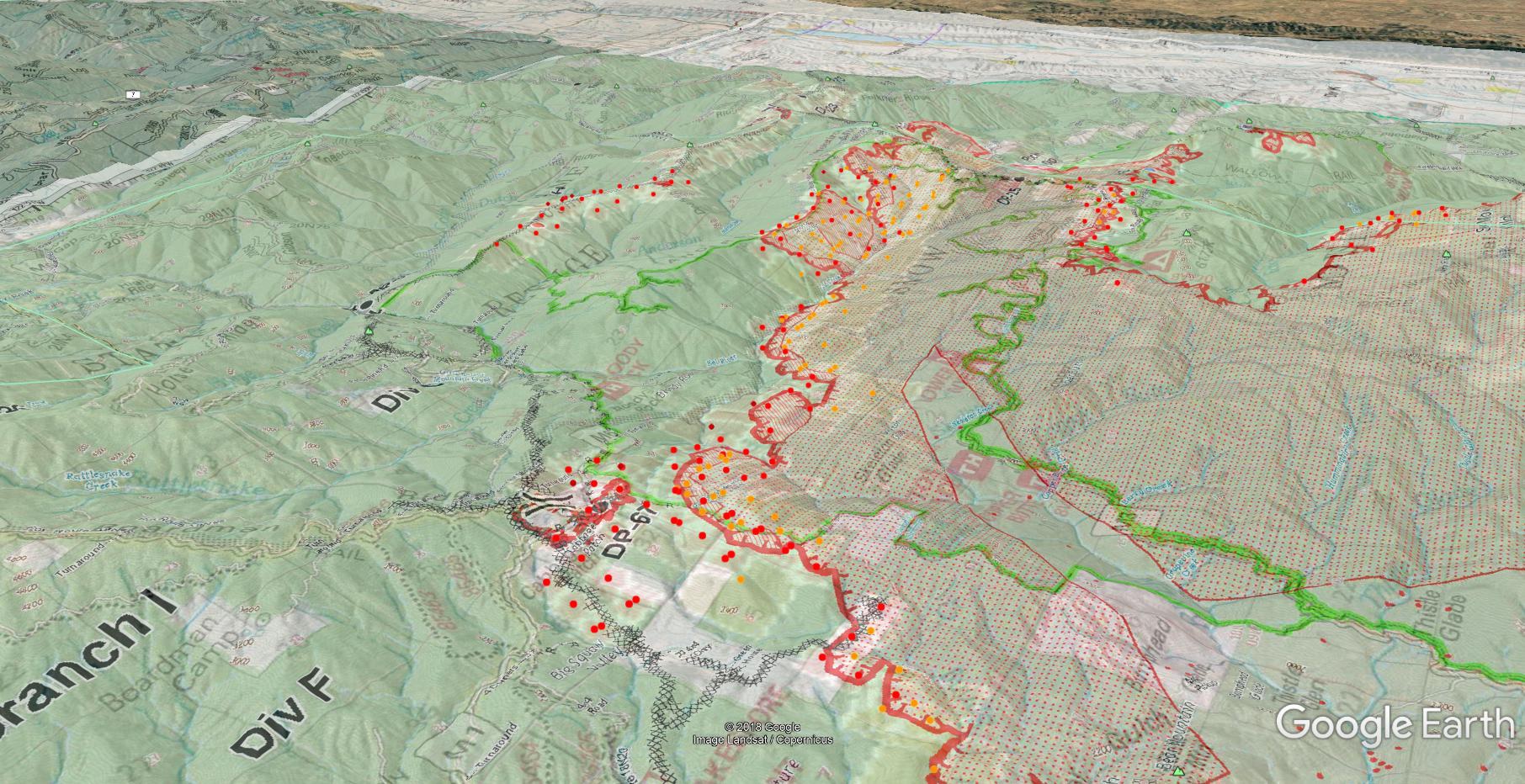
Looking NE onto Div F from over Lake Pillsbury to give an idea of the terrain and hard work they have going over there.
6 Likes
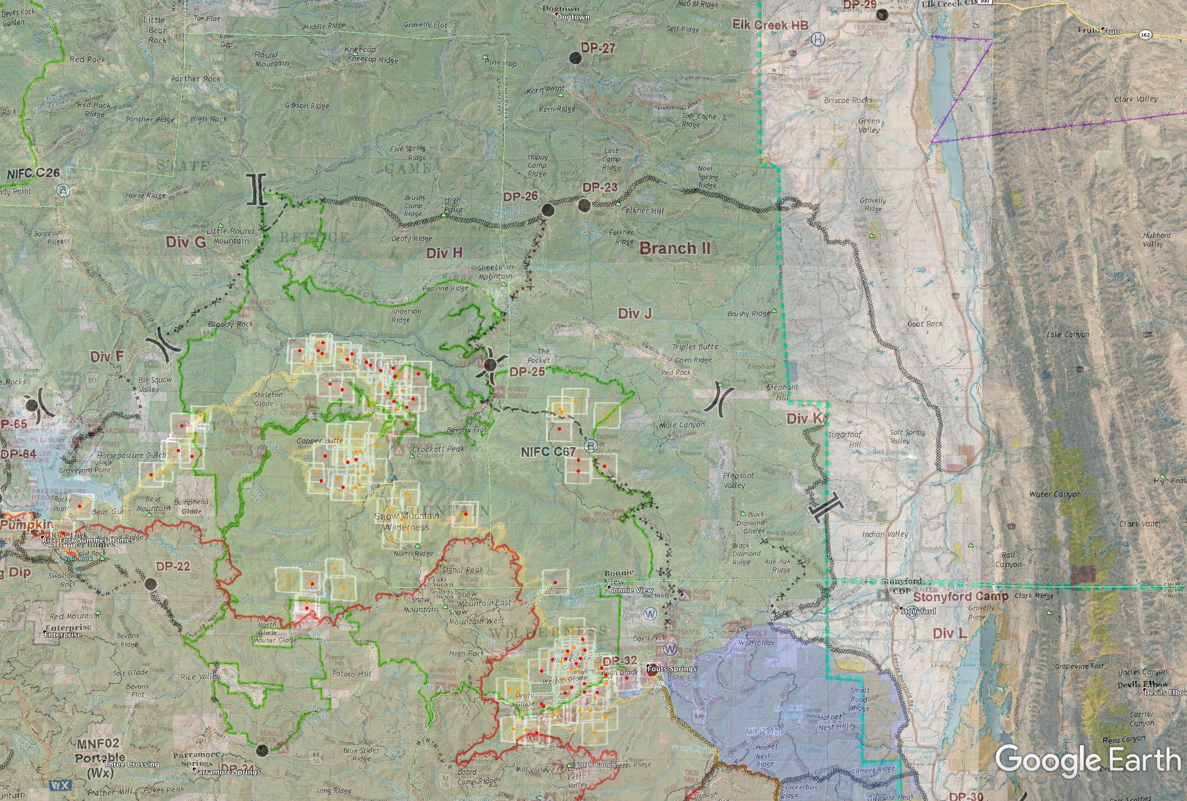
I’ll just post one map this morning, showing the IR perimeter from last night, on top of yesterday’s Ops map (with Monday night’s perimeter visible as faint red), with MODIS/VIIRS as of this morning. It really shows the excellent firing ops that occurred Monday evening into Tuesday and tying in some good black from Lake Pillsbury up through Boardman Ridge, then up the M6 towards Bloody Rock. That’s about 6 miles of good fire on Div F into G, with only 3 miles left to tie into Div H. On Div H they have about 12 miles of good fire from G/H break DP69 along the ridge east to between DP73 and DP75 in Div I. If they tie those last 3 miles together, then it can be pretty much a done deal to the west and north.
A LOT of open land on the east side to contend with.
3 Likes
anyone have link for iap? haven’t updated the ftp since 8/19
1 Like
Looks like they started the firing down G early last night and then VIIRS picked up the heat continuing down the line and possibly tying into the fire coming up from F and bottom half of G. If that gets tied in then we have an excellent check to any further spread west or north. Which brings us to the east side, errr, east zone. Good fire continuing east along the line up and over Felkner Hill and to the forest edge down Noel Spring Ridge. They also fired down Felkner Ridge south. IR picked up a tiny bit of fire it appears along the line at the bottom of St. John Road. Not sure if that was a test burn or abandoned etc. No MODIS hits on it. My armchair qb’ing has always been wondering if they would try to hold it at the St. John Road or take it all the way to the dozer lines on the forest boundary and into the SRA.
The fire was zoned yesterday as the Fed IMT came on board. East and West zones, or as the folks in the camps are calling it, the red and green zones. East Zone setup CDF Command 11 yesterday. I have that on priority along with West Zone command on the http://norcalscan.live live scanner.
Weather forecast today and tonight is good with hopeful RH recovery from marine layer, and only terrain/local wind influences, gentle upslope in morning and downslope in evening. Stronger in the East-West aligned terrain.
Map is Tuesday’s OP map georectified over Google Earth just to get the incident labels and dozer lines, so ignore the old internal red perimeter (other than progression since Monday night). Outer thin red is last night’s IR. MODIS/VIIRS as of this morning.
5 Likes
1236: Air Attack is requested 3 VLAT and 3 LAT up and over the East Zone. They will be pre-treating a lot of critical dozer line in J and K. Haven’t seen much fixed wing over the incident for quite a while. I should have the bulk of the airshow on the live scanner if they remain on the northeast portion of the fire.
2 Likes