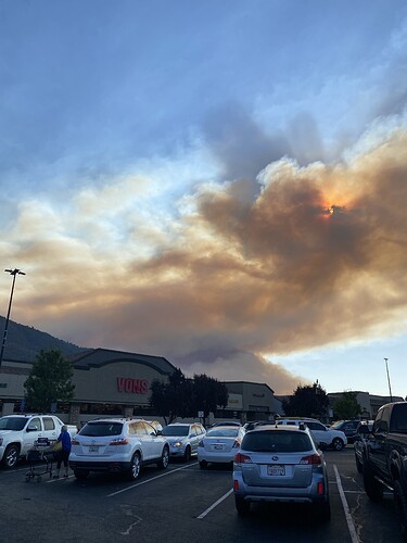
I heard 2500 and 0
From a couple of reliable sources 2500 acres.
South Ops News & Notes has it at 2500 acres @ 1900 hours.
Spot across road 600. Division asking for rotors and fixed wings
This demonstrates the interesting wind patterns that are present over the area. Of course once the sun goes down it will be entirely different with a new set of issues. From “downtown” Oakhurst.
AA saying fire is closer to 3000 acres now.
Yes you were correct. I heard the recording just after sending.
Tankers are done for the evening.
Nor to live under a TFR for three weeks!
Caltopo is now showing the fire:
https://caltopo.com/map.html#ll=37.36125,-119.86668&z=14&b=t&o=f16a%2Cgoes_0&n=1,0.25&a=fire%2Cmodis_mp
Appears to be the start of the fire. Not yet updated with the current position of the head. Check back later…they will catch up.
AA says 5,800 acres.
TCU just toned out another ST 9442C immediate need to the fire.
Mapping support website is getting some early heat overlays on topo/aerial as well.
Use the drop down menu upper right to change the underlying base map and features.
https://mappingsupport.com/p2/gissurfer.php?center=37.344854,-119.863672&zoom=14&basemap=ESRI_scanned_topo_USA&overlay=VIIRS_24_hours,MODIS_24_hours,State_boundary,Wildland_fire_name,Historic_perimeters,ESRI_roads_and_labels&txtfile=https://mappingsupport.com/p2/special_maps/disaster/USA_wildland_fire.txt&data=37.384583,-119.863586
(I made an error earlier above, this one is correct @ 23:00)
ADD the nearest raws station in Metcalf gap, kinda where the fire head is running to:
Click on daily summary (will bring up todays date) click submit for recent 24 hours reports,
https://raws.dri.edu/cgi-bin/rawMAIN.pl?caCMET
Calfire update 4000 acres. 100 acre slop over by Grupe ranch airstrip crews pulled back.
AA51 mapped it, 4800 acres.
Caltopo is now currently updated with the head of the fire:
https://caltopo.com/map.html#ll=37.32688,-119.83782&z=13&b=t&o=f16a%2Cgoes_0&n=1,0.25&a=fire%2Cmodis_mp
This is a link to the MMU tree mortality georeferenced map. Keep in mind it’s from 2016…
#RiverFire
#MariposaCounty
#MaderaCounty
@CALFIREMMU
The fire stayed very active last night and has moved quite a bit closer to Rd 800. Access is difficult and today is going to be very challenging… Scanner traffic summary. getting ready for firing ops along Rd 800. https://twitter.com/TrishasWCFireWx/status/1414585236176871425/photo/1

