
Thank you for that. My mother in law lives near Lewiston.
Remember that there is a separate thread for questions and discussion. I know on the old site, they were very picky about such things.
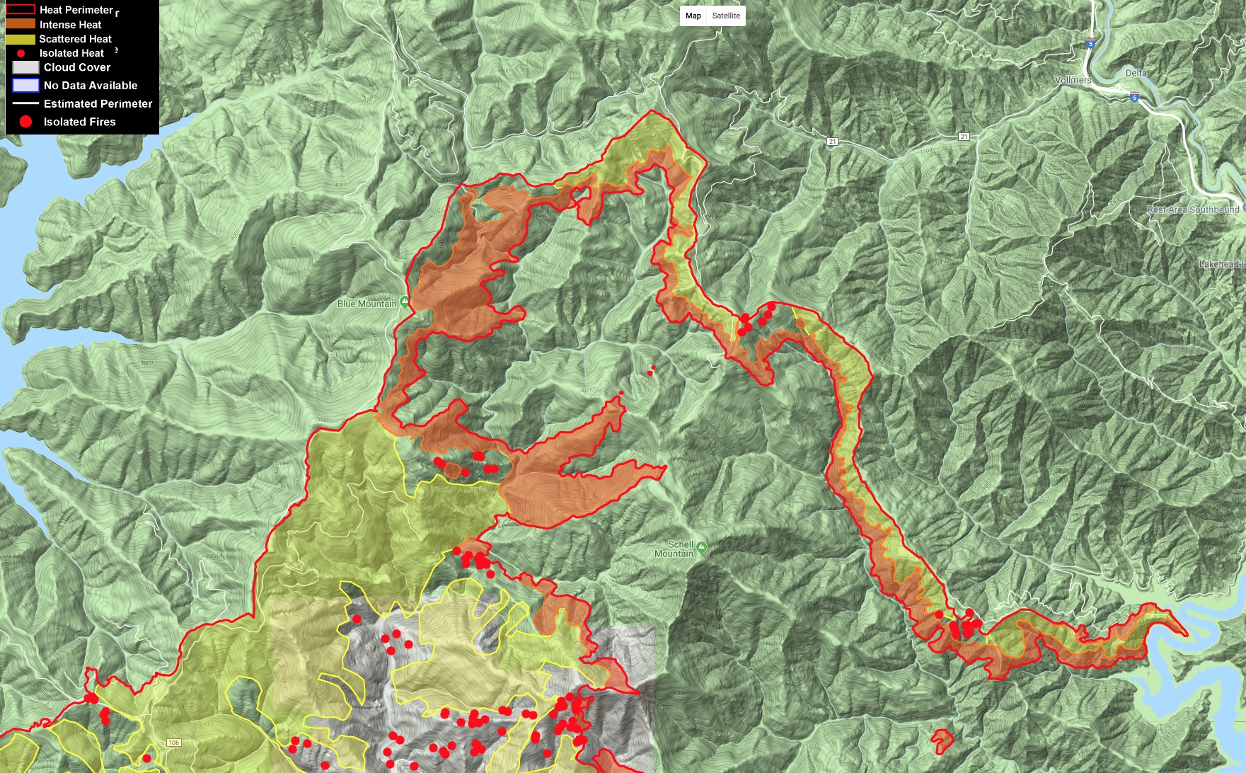
New growth, as of last nights IR, was 7642 acres. IR maps and log:
https://ftp.nifc.gov/public/incident_specific_data/calif_n/!CALFIRE/2018_Incidents/CA-SHU-007808_Carr/IR/20180807/
IAP:
Tuesday’s “What We Know” article from the Record Searchlight:
5 Likes
Sounds like a pretty good day on the fire. Quick update for the night:
- Div B (above Shoemaker Bally in Trinity County): Plan and prep all day for firing ops. Starting firing ops now with favorable conditions.
- Div A (below Shoemaker Bally in Shasta County): Lots of good work in there per Helco.
- Div Y (above Ono between Rainbow Lake and Igo): Also lots of good progress, everything still in check. If all goes well should be starting some firing operations tonight as well to bring fire to the line.
Lots of utility work with PGE and subcontractors replacing poles, towers, and restoring many spans in the area.
7 Likes
Has anybody either witnessed today’s activity or have good local knowledge of the activity since yesterday’s update?
Fed resources began burning operation on the north lines near Lakehead this evening.
3 Likes
The updated modis thermal map shows spots on the northern end. Any updates from troops on the ground? Burn op?
Hope I posted this correctly…
https://m.box.com/shared_item/https%3A%2F%2Fwww.box.com%2Fs%2Fdo2rhtx0zkylf0ppl4r0
Massive firing op in anticipation of the red flag winds. Firing went well, hope it holds.
1 Like
Here is this morning’s perimeter, MODIS/VIIRS hits and the dozer line they’re working with on the north end. It is a combination of excellent data from the incident that paints a great picture of what’s going on. You can see the large open line there west of Schell Mtn, and the dozer line along Backbone Ridge that they are firing off, including other ignitions it appears off of Blue Mtn.
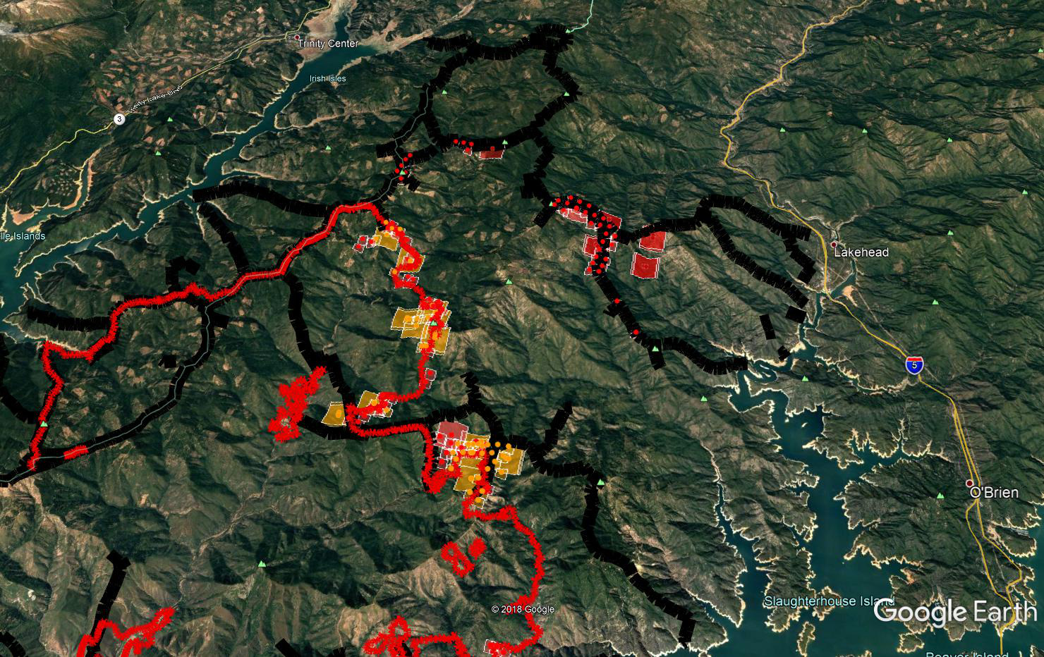
4 Likes
Spent the last 24 on Alpha. Over the last few shifts crews have been pretty successful dragging fire between the A/Y break all the way to the B/C break. Nice south wind was helpful yesterday. If it all holds for the next few days it should turn black on the map.
3 Likes
Today’s IAP.
2 Likes
Thanks for the IAP
2 Likes
Live memorial for Jeromy Stoke
1 Like
That was a large scale burn show (maybe 10k acres?) on Div O. I think I heard that they were Delayed Aerial Ignition Devices today
1 Like
I’m a tender up in that Div. P/S. It was a good show with favorable winds.
The aerial burn show might happen today based upon conditions. Instead of stripping out the whole area, the plan is to just light off the spur ridges and let it just back down slowly. The concern is that if it gets too big a column it could collapse outside the lines.
5 Likes
201,680 acres with 61% containment.
3 Likes
Burn went well in November. Initially smoked out but got to around 14:30. Will be back tomorrow to continue out towards the lake. Division Papa hand burn also going well, good depth and fire pulling to the interior. 2 shot crews cutting line across the land arm between Bull creek and Elmore creek to try save burning the whole thing. They are about quarter way up the North side right now.
Couple more days and hopefully it will be a done deal.
13 Likes