Winds starting to shift the smoke over and inversion lifting. AA requested six T1 and four T3 tankers. Only two T1 and three T3 at Redding now. They have been discussing all morning the plan to paint/pre-treat a pretty big box with retardant today to support the iron on the ground.
5 Likes
Air resources are going to become harder and harder to get with new and continuing large fires throughout the state.
We’re definitely losing a lot of fixed wing to BDF-Cranston, SCU-Marsh, and coverage fills.
It sounds like they never got to fire off the bowl I mentioned last night off Brunswick Ridge in Div C. They are planning on doing it tonight instead now. The tankers were to help reinforce the dozer line and cool it around the 500kv line. Also, Div H has been firing early this afternoon from the top of the knob in Sec21 down to Tom Green Mine Road I believe.
2 Likes
Per CAL Fire 6,773 acres - 10% contained
General summary of afternoon and evening:
- Lost the heavy tankers to other IA fires
- At 1920, 800ft to tie in from Div H to Div C then Div H firing op will be complete.
- Heard lots of good stuff from ground and air about the Div H firing op, sounds like it will be successful
- Spot fire this evening in downtown French Gulch - 3-6 acres. Stomped on it quick.
- COMT testing out NIFC Cmd3 170.425
- They are expecting the same wind behavior as last night, a rapid switch out of the west at sundown. Last night at sundown with the wind shift is when it spotted across Div X on the east side and lost the east side. AA was consistently relaying that concern to Div X and M this evening, concerned for iron up on the ridge lines that it was a very rapid switch when it occurred last night.
5 Likes
Spot weather forecast:
https://www.weather.gov/spot/php/forecast.php?snumunum=1813348.2&lat=40.69472152832682&lon=-122.21448662109378&z=8
3 strike teams of Charlie’s and some volunteer stations being called to the contingency, reporting to rock creek road x 299. Anyone have any word on if the fire escaped the burn operation or what’s going on ? Just got toned out to this assigned to south structure group
1 Like
OES 334 in route from Grass Valley.
4806 A with El Dorado, Georgetown, Roseville, and Winters FD.
1 Like
New evacuation orders for Iron Mountain Road, Rock Creek Road, Old Shasta, and Keswick.
Fire is making a big run. Very prominent on GOES-16:
http://rammb-slider.cira.colostate.edu/?sat=goes-16&sec=conus&x=658&y=3612&z=4&im=30&ts=1&st=0&et=0&speed=130&motion=loop&map=1&lat=0&p[0]=20&opacity[0]=1&hidden[0]=0&pause=0&slider=-1&hide_controls=0&mouse_draw=0&s=rammb-slider
Road closure moved:
Updates to the KRCR article:
Edit:
KRCR tweet from 6 hours ago:
1 Like
The Record Searchlight (local paper) has a new article up this morning:
9160C ENR to the fire
1 Like
Local Redding news puts it at 20,000 acres as of 0645.
1 Like
This mornings 209 also says 20,000 and transitioning with CALFIRE Team 1
1 Like
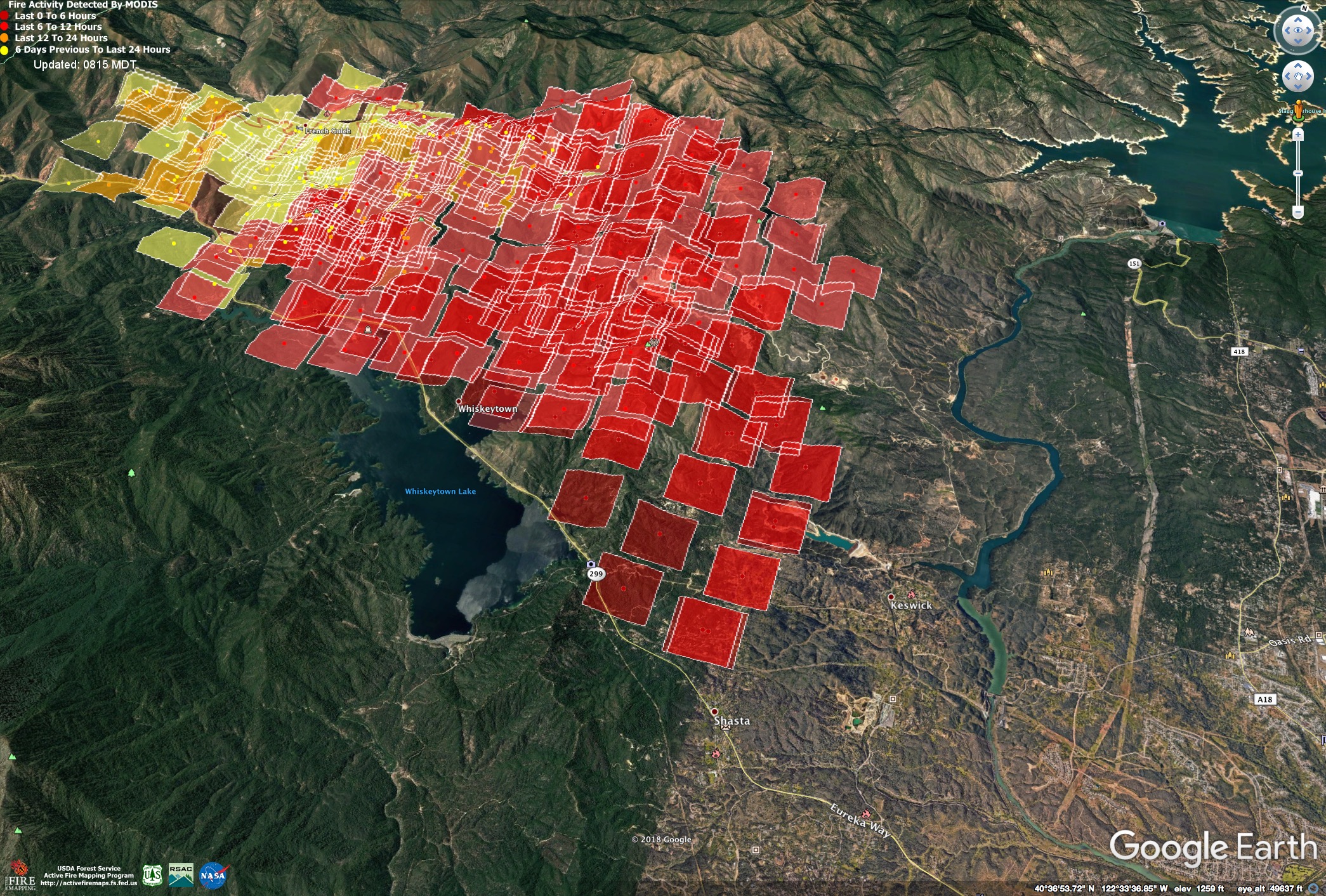
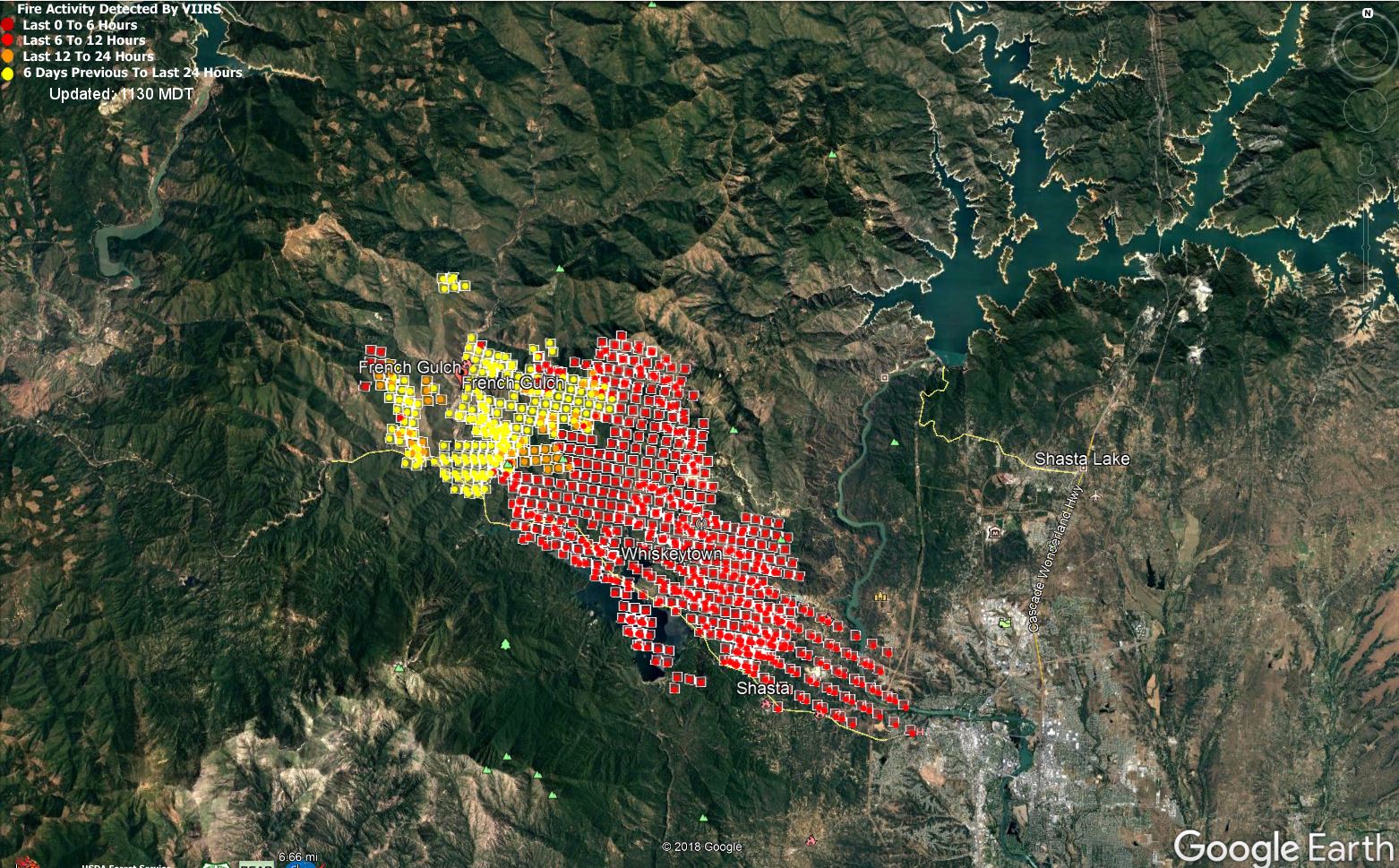
Here is a satellite heat map as of 3am.
MODIS data, which is usually accurate within about half a mile.
The MODIS area measures closer to 30,000 acres, but if the fire is column-driven, it can show heat in the column.
10 Likes
Officially calling it 20,000 acres and 10% contained. It may be larger based on the above screenshot.
Hearing that it jumped 299 to the south side around Swasey but not confirmed. It is confirmed that members did structure protection at Cal Fire Station 58 at 299 and Iron Mountain Rd.
Sounds like it’s setting up like the Incident Managent 3 Class simulation.
1 Like
There is a 15acre spot fire on the south side of the lake, across from Grizzly Gulch, which is Oak Bottom Marina, and just east of Carr Powerhouse. This is highest priority now for aircraft. HelCo found an opening and is waiting at the Sac River for two heavies to guide them in through the smoke to this spot fire.
edit 1008: “made it to the spot, night resources have it about tied in” just got approval to run dozers in the park on this.
Lots of immediate need resources being dispatched/reassigned from NOPs forests
Well it looks like the lake is burning, but I think this illustrates what @pyrogeography mentioned above about the satellite imagery picking up the heat of the column. At least I hope thats whats going on.
2 Likes