Thanks norcalscan, my kid is on RDN and it’s different when all you can do is watch, listen, read.
3 Likes
Amazing. Fire creates their own weather patterns.
CHP CAD at 1914 reports CHP Telecom advising fire has burned over Shasta Bally around their repeater. I’m still a hair skeptical of this, but if they’re doing it right, they certainly have the vault temp sensors or potentially live video from their tower. But no other reports of this yet, and every other scrap of intelligence I have keeps pointing to “not yet”. Both FM and TV broadcast up on Shasta Bally are still on. If I post my confidence levels like a MODIS hit, I’m right at 50. How’s that for committed?
edited: better wording
3 Likes
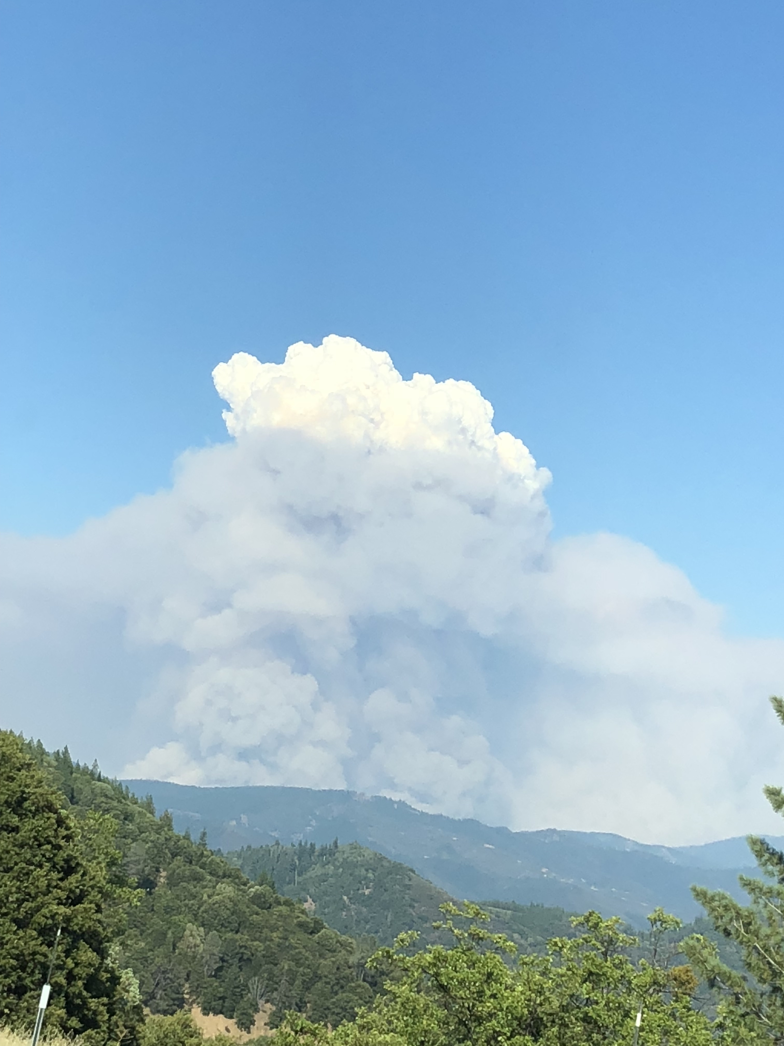
How long ago was this taken? I’m on a task force just pulling into Anderson and everything is socked in on this side.
1 Like
Rookie, my kid is too, and I agree!
500 homes destroyed per cal fire
This was taken at 1730.
On order in ROSS at 1900 7-27
7 type 1 strike teams
17 type 3 strike teams
3 type 6 strike teams
4 type 2 dozer strike teams
17 dozer any type single increment
10 type 1 crew strike teams
Today’s IAP:
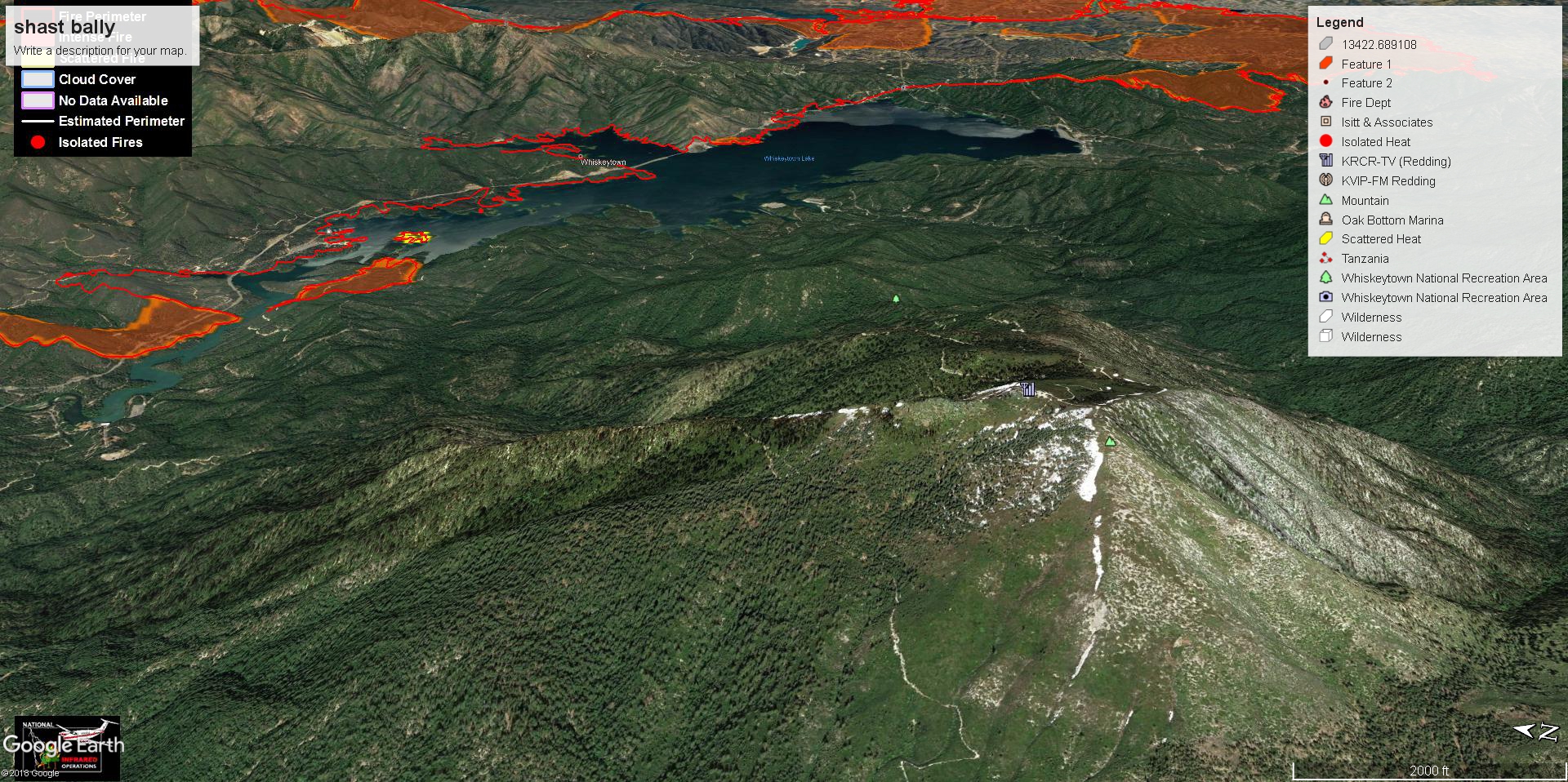
IR:
Ops IR Map:
PIO Map:
1 Like
Latest spot weather forecast, from 0245 on 7/26:
https://www.weather.gov/spot/php/forecast.php?snumunum=1813497.0&lat=40.61971140304175&lon=-122.94233085937495&z=7
Edit: Actually this is old. I assume team has an IMET assigned forecasting now.
This is not valid…it is the 28th today.
1030 update good morning. Had to unplug last night to get the brain unscrambled. They abandoned the NIFC command setup this morning and switched back to CDF Command 2 on Hoadley Peak. I’ve switched live scanner back to CMD2 as primary and left the NIFC’s in the normal scan. I’ll revert back if they move back to NIFC.
North Side Branch 3 - got a decent push north last night as they were expecting. Up the Trinity mtn Road area. Some homes and ranches up there, and some residents who have refused to leave. The further north it marches the harder and harder it will be to get resources up there. Very rural and limited road systems. Slow going. To the west in upper Branch 2 Div H, it’s also making the push up to Hoadley Peak which is the Shasta/Trinity County line, and their primary objective for the west side. Hoadley is the site for CDF CMD2, their primary command repeater for the incident, and state radio microwave site. There is a spot fire on the north side of 299 somewhere in the S curve climb up to Buckhorn (also Shasta/Trinity Co LIne and road access to Hoadley) and they pulled out some resources that were making their way to Hoadley due to this new spot it sounded like in last 20 minutes. This spot fire is also west of the firing op from night 2(if I recall?) that produced some of the only black controlled line on this fire (that 5-10% containment number we were seeing).
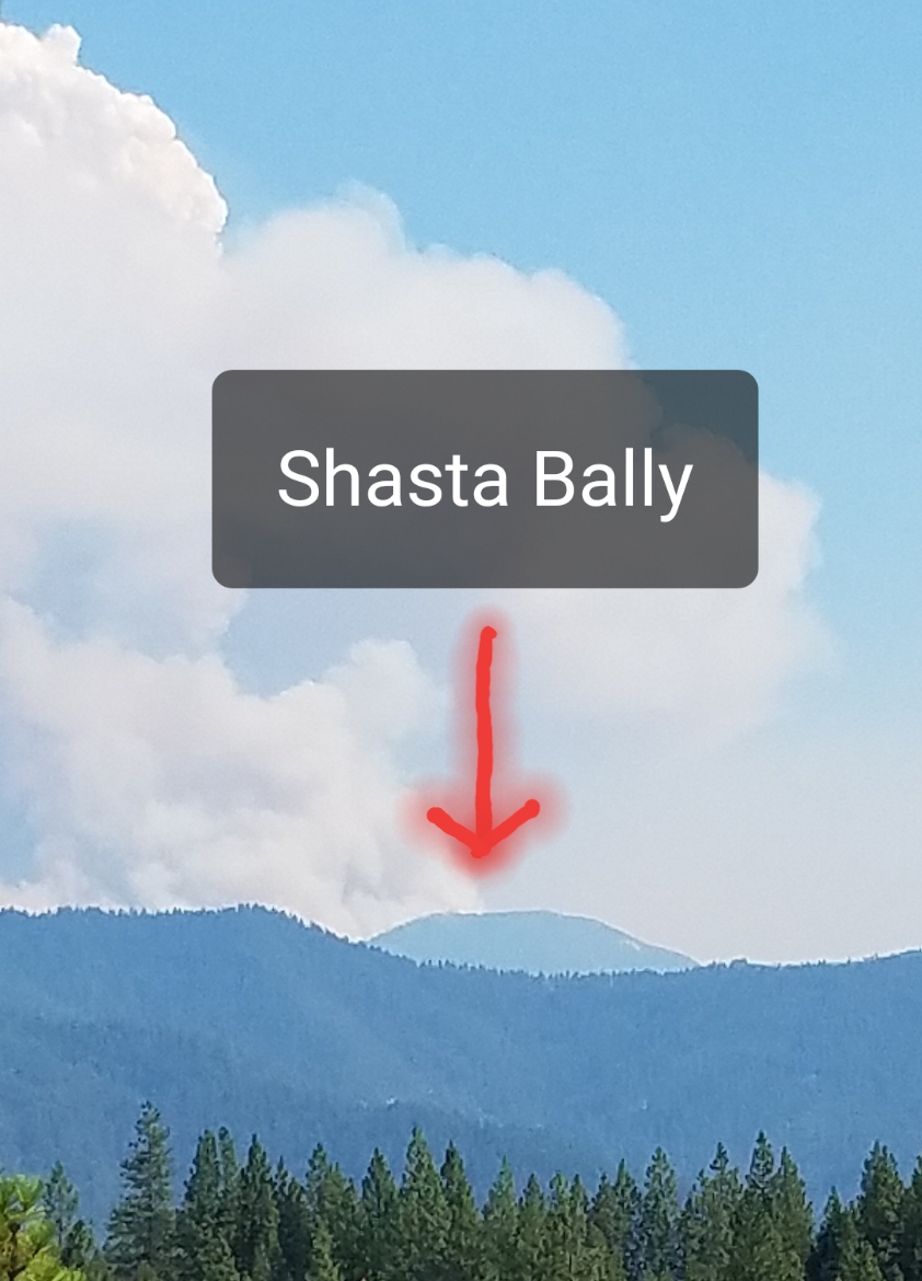
Southwest side Branch II - if I heard properly this morning, fire made it up Shasta Bally last night, but the repeater site is okay or not burned over yet. Broadcast is still up thankfully - TV7 continuous live coverage is the primary source of info for every civilian up here at the moment. Trying to get a copter in for a repeater mission on Bally (just got negative due to smoke.)
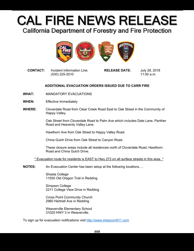
South side and Branch 1 area - fire made a HUGE push south into Igo. The Vets Memorial Bridge on Placer Road over Clear Creek got burned over in an extremely hot burn and is now compromised. Life hazard taped off and no resources can go over the bridge. Logistically - that’s a mess. Only way in/out is Clear Creek Road (until fire inevitably reaches there soon) and Gas Point Rd due south. Or Platina Road towards Platina. There are some recent fire scars this season and recent seasons this fire will hit as it makes its way south in this area. However there’s a lot of dead standing fuel in those scars along Cloverdale and Clear Creek. Happy Valley community is now in direct path for next 12-24. Really with whatever winds it gets, it can steer anywhere and it will be continuous WUI. Lots of residents still in Ono, claim they didn’t get the evac notice - Ops requesting Law go back through there with mandatory evacs now. This side of fire is what will get media focus due to the direct impact on civilians.
The entire SW side of this fire experiences Arbuckle Winds, at 3pm surface winds get up to 30mph N-NE.
East side on the Redding side looks pretty good, but is the least of my intel. It appears the wind shifts aren’t driving this side of the fire like it did previous nights. Lots of hot spots, re-ignitions and general war-zone-ness from the surge 2 nights ago. The upper Sac River canyon below the dam remains a wildcard. Not sure what progress they have up there, if it gets over the river then Shasta Lake City and northern Redding will be direct threat.
And MEU-Mendocino Complex and LNF-Whaleback are direct competition to resources today, along with spread out IA.
21 Likes
Air is clear enough to get tankers into Hoadley Peak. AA launched the aircraft and told ops her goal of boxing in the repeater site with retardant. Ops had a heartfelt “thank you” at the end of his reply.
Not sure why NIFC is down but I think some links aren’t working, or the hub itself. They really wanted to get a copter up to Shasta Bally and it got denied due to smoke. AA will continually reassess the conditions.
edit: forgot to mention the spot fire over 299 west of the black, it sounds like it was right near the 500kv powerline crossing, which is where the previous black was, and that they had it in check. However a lot of fire has moved west below 299. So there is a lot of open potential for spotting over 299 to the north west of the black.
7 Likes
Thanks Norcalscan for the great size-ups.
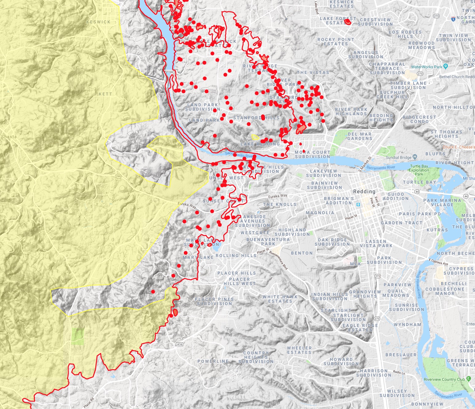
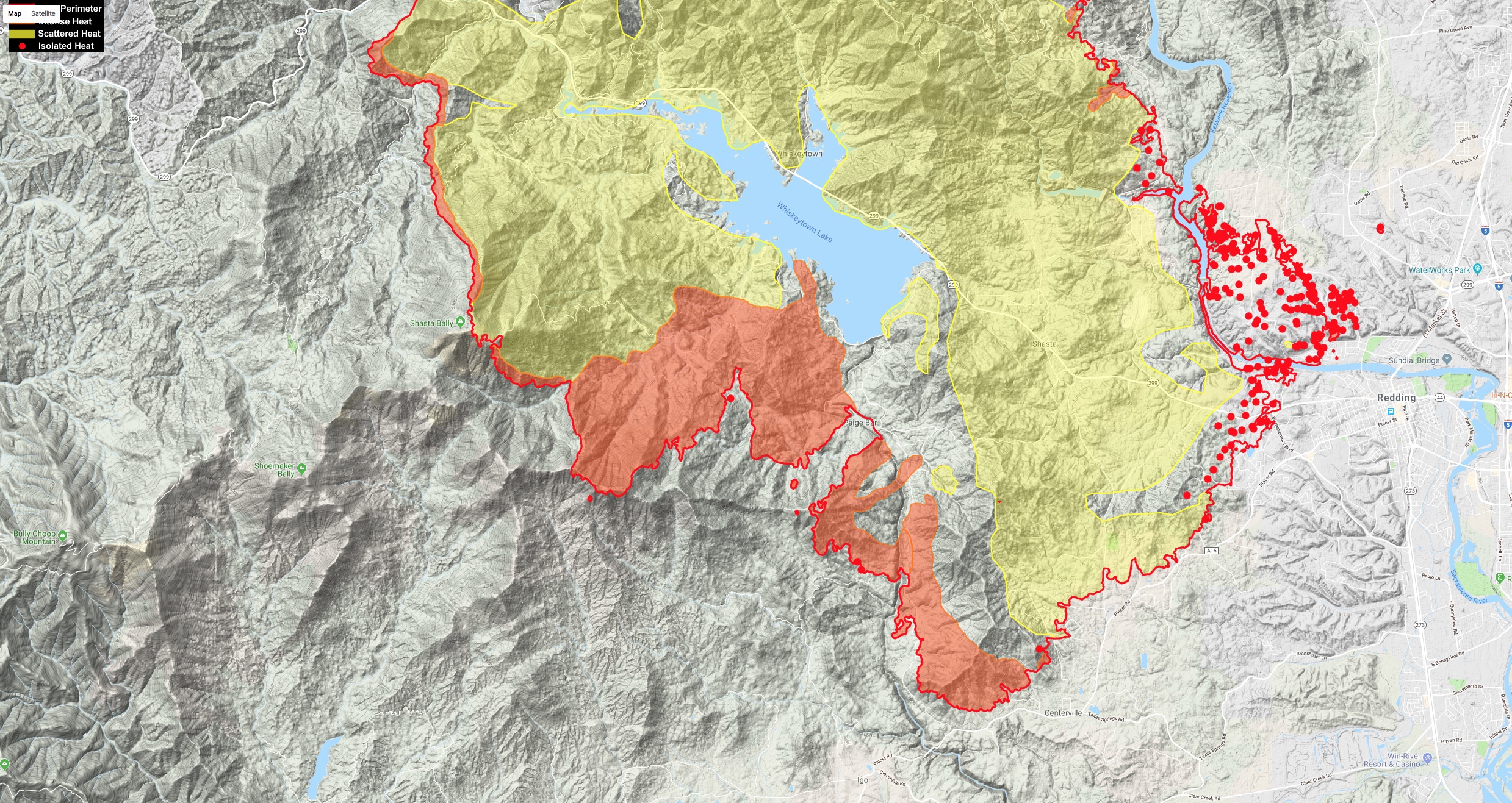
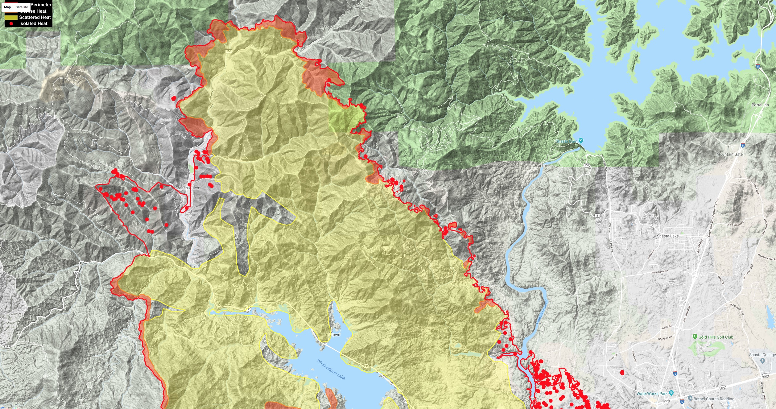
Here are a couple maps with last night’s IR - 01:45 this morning.
6 Likes
Air Attack has been assessing County Line Road for the last hour, which is the road along the county line (smirk  ) off Hwy 299 at Buckhorn Summit running north along the ridge top to Hoadley Peak. Div C and H.
“That is a multi-day project with the VLATS, and they don’t have any VLATS and only a few LATs due to aircraft diverts. We won’t be able to do much of anything on that ridge.” She has a very healthy dose of skepticism and realism today, which will probably keep a lot of FF safe. “We aren’t going to paint it just to paint it. if you’re going to support it then we’ll paint it. Otherwise it’ll burn right through.”
She released all her fixed wing back to load and hold.
11 Likes