
Spent the last 24 on Alpha. Over the last few shifts crews have been pretty successful dragging fire between the A/Y break all the way to the B/C break. Nice south wind was helpful yesterday. If it all holds for the next few days it should turn black on the map.
3 Likes
Today’s IAP.
2 Likes
Thanks for the IAP
2 Likes
Live memorial for Jeromy Stoke
1 Like
That was a large scale burn show (maybe 10k acres?) on Div O. I think I heard that they were Delayed Aerial Ignition Devices today
1 Like
I’m a tender up in that Div. P/S. It was a good show with favorable winds.
The aerial burn show might happen today based upon conditions. Instead of stripping out the whole area, the plan is to just light off the spur ridges and let it just back down slowly. The concern is that if it gets too big a column it could collapse outside the lines.
5 Likes
201,680 acres with 61% containment.
3 Likes
Burn went well in November. Initially smoked out but got to around 14:30. Will be back tomorrow to continue out towards the lake. Division Papa hand burn also going well, good depth and fire pulling to the interior. 2 shot crews cutting line across the land arm between Bull creek and Elmore creek to try save burning the whole thing. They are about quarter way up the North side right now.
Couple more days and hopefully it will be a done deal.
13 Likes
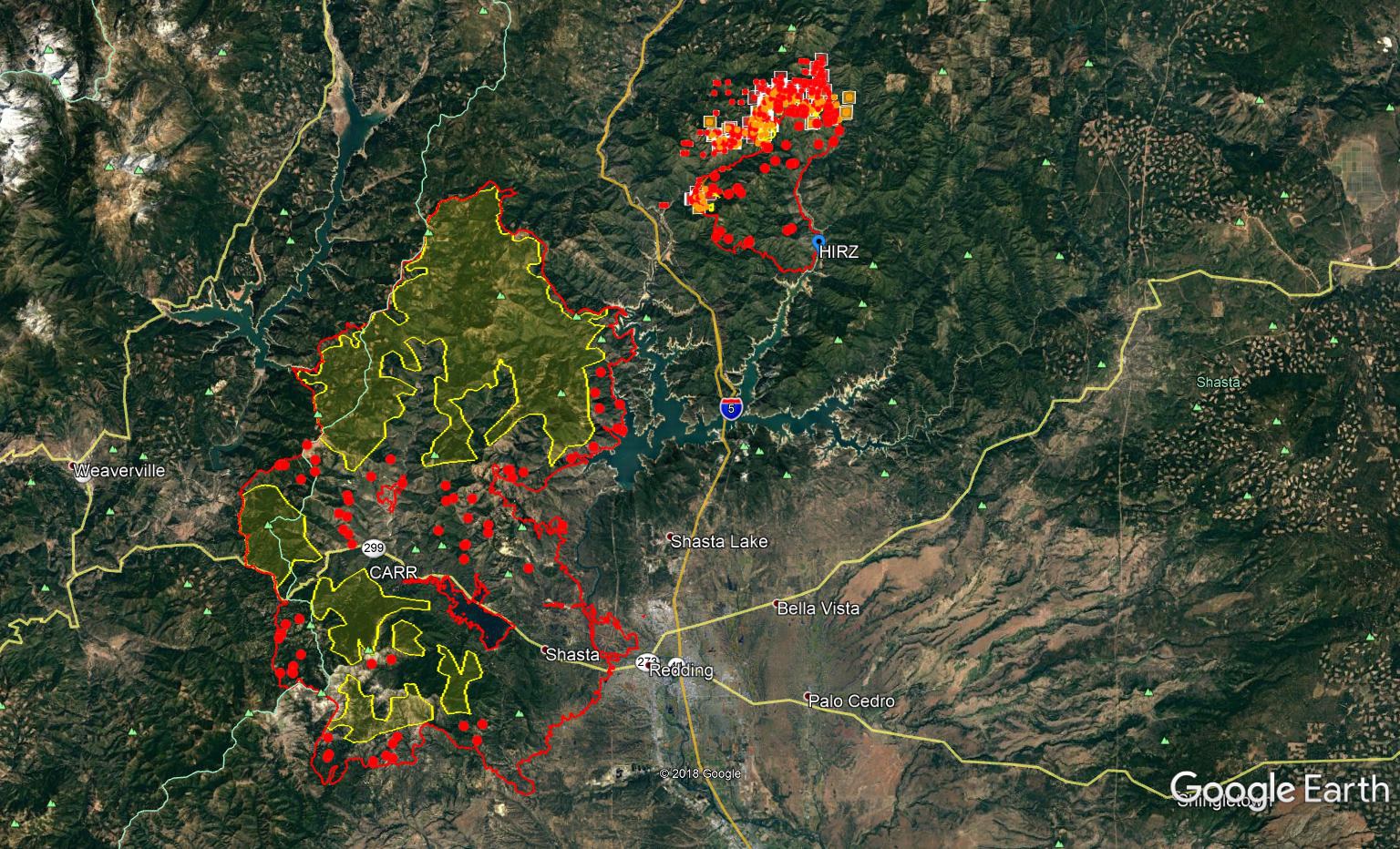
This morning’s perusal of MODIS/VIIRS (unfortunately becoming as ritualistic as the morning coffee) shows for the first time no MODIS/VIIRS hits in the last 24 hours over the entirety of the Carr fire footprint! Still plenty of hot spots that IR can see, burning root balls, smoldering etc. What a fight! Like we’ve learned from previous large incidents, the task at hand won’t stop for years though with repairing suppression efforts, environment and watershed repair as fast as possible before the winter rains, utilities, rebuilding homes, lives, insurance paperwork, communities, economies etc. Shasta Strong!
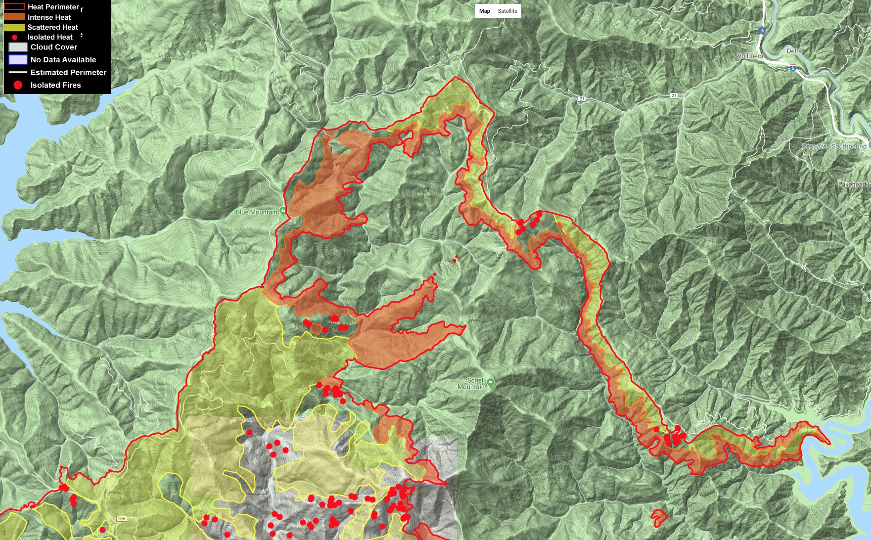
Map is last night’s IR of both Carr and Hirz fires, with MODIS/VIIRS hits of the last 24 hours.
5 Likes
Holy Hell just drove over to Rdg yesterday for the first time since Carr… I just drove silently as tears streamed down my face… I’ve lived in NorCal my whole exsistance, between the ElDorado & the Shasta Trinity, in the four decades have I ever seen anything like this. I’ve been evaced a time or two & watched plumes growing but the total moonscape…there are no words. None… just literally heart wrenching.
6 Likes
Here’s an excellent article on the communications sites that were burned over and what it took to maintain/restore them during and after the fire. I’ve been to countless sites and can say many are completely neglected in brush clearance, fire survival etc. I think it’s a miracle the brush was mitigated early season on Southfork and Redding did not lose their primary PD (trunked) site that night, because evacuating 38,000 people out of the city the following day with crippled communications would have made a larger disaster.
Talking with an ATT microwave tech yesterday he mentioned they lost their fiber up to Southfork which crippled that cell site so they were up there as well the day after to get a microwave link in to restore service.
I went by SHASCOM the evening the fire entered the city, they were still on gen power and they were all hands on deck for sure. The building is pretty survivable but has trees right against the building and would have impacted their generator, and they are against a greenbelt on 2 sides. Incidents like these definitely make you look at vulnerabilities in a different light…
3 Likes
100% Contained
7 Likes