Walker mine road x Flannigan road
North west Redding. Augmentation including aircraft.
1301
Additional incident in South county. Kimberly road, 2 acres rapid ROS grass and brush.

Walker mine road x Flannigan road
North west Redding. Augmentation including aircraft.
1301
Additional incident in South county. Kimberly road, 2 acres rapid ROS grass and brush.
Per C-205
Fuel driven, short/mid range spotting. Left flank is priority.
AA and 2 tankers Enrt.
1330ish 20 acres
Holy batman that spotting and fuel behavior, less than 24hrs after a trace of precip came through the area yesterday (first precip in 40+ days?)
WX PGE Pine Grove 58F, 30RH, 11G20 WSW (1/2mi east of incident, maybe 200-300ft lower in elev.)
Fixed wing at MCC still not in the air yet. (update 1340, T85, 89 off MCC)
T-85
T-89 off mcc
Mandatory evacs walker mine rd
RDN B-2 structure group
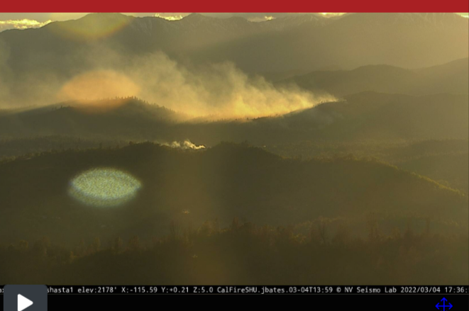
Looks to be burning just above this neighborhood. Thinking the Shasta Lake webcam is not necessarily representative of overall burning conditions, though, as it only really shows what’s happening on the most sun-exposed part of the fire.
T 90 + 1 additional tanker Enrt(total 4)
30 acres
Chico AAB open for reload
Additional request for resources for structure defense, yellow pine x walker mine
T 96 is the additional - Anyone hear about an AA?
No AA so far. C102 and 202 enroute (C102 I thought was out of play earlier, but was simply dodging storms)
Traditionally I’d say a drop caught on a camera is nothing out of the norm these days… But March 4th, in SHU!?
Kinda surprised they’re running tankers (now up to four, and I know there’s two CL-415 scoopers parked there as of two days ago) out of Chico instead of Redding. Guess the latter must not be worked up yet?
EDIT: Columbia’s got a CH-47 warming up at McClellan, looks like, and another chopper’s coming down from the Modoc area. With these gusty northwest winds, even with a bit of recent precipitation this might be trouble for houses nearby.
Wildfire - #FLANAGANFire
Map Link: https://napsg.maps.arcgis.com/apps/webappviewer/index.html?id=6dc469279760492d802c7ba6db45ff0e&query=USA_Wildfires_v1_5644,UniqueFireIdentifier,2022-CASHU-002384
#FireMappers https://twitter.com/pjdohertygis/status/1499882603154853888/photo/1
Per AA 50-55 ac.
The Scoopers are there for training/checkrides… much better weather in Chico than Spokane to knock those things out. They are not on contract.
If someone has a contact with the Shasta county air quality management district tell them they need to update the burn info on the 1-800 number.
New start right down the hill it looks like or may be a spot just popping up, the column was leaning over that location.
All,
Please refrain from speaking off topic within this Q&D. All posts that were related to VMP’s, escape burn piles, private homeowners burning etc, were moved to the General Discussion thread under VMP’s. Carry on.
MOD-FJ
Did Cal Fire ever release a report/AAR on this escape/incident?

