CA-TIA-Windy

AA is up over this two incidents. Requesting to S2 tankers and Lead plane.
Good visibility.
Believe they are sharing tankers between fires.

EDIT Update 10:20, Firewatch 51 flew IR on the fire and shows 230 acres and high potential for southern spread.

3 Likes

Type 2 (Fogal) team ordered, inbrief this evening. ICP is at the Porterville Fairgrounds

5 Likes

Traffic is the crews are working with a couple of dozers to open up the road systems for primary holding and contingency lines. Tankers are still working on load and return for many hours now. Lost 2 tankers to start nearby in Park and considering a VLAT to replace those along with one LAT.

Still a slight build to the smoke on BlueRidge2.

Just showing a little heat on the RAMMB Goes17 page.
https://rammb-slider.cira.colostate.edu/?sat=goes-17&sec=conus&x=8008.5&y=3961.449951171875&z=5&angle=0&im=18&ts=2&st=0&et=0&speed=220&motion=loop&maps[borders]=white&lat=0&p[0]=fire_temperature&p[1]=geocolor&opacity[0]=1&opacity[1]=0.5&pause=0&slider=-1&hide_controls=0&mouse_draw=0&follow_feature=0&follow_hide=0&s=rammb-slider&draw_color=FFD700&draw_width=6

1 Like

Looks like 4 plus heat signatures showing???
looking at Natural Color…just seeing the one heat signature…maybe others where false???

2 Likes

AA132 was up this morning and returned to Porterville. No air show so far.

Incident specific FTP site has only a map for this under a TIA Inc#3058. It’s old data from day two AM IR.

Hear both Ch.4 and Ch.2 traffic about this incident. A lot of traffic is “call us via cell phone”. This will be a trend as these old analog radio systems haven’t grown to meet modern demands and modes nor expanded sites.

5 Likes

I do hear air tankers back on the AirTactics 169.200 dropping on which fire I haven’t determined.

Also so IA traffic on CDF AirTactics 6. Maybe a TUU or FKU incident ?

However, there is good build showing from the valley floor:
http://www.alertwildfire.org/sierra/index.html?camera=Axis-GarcesHwy2&v=fd40740

2 Likes

Fku has 2 small incidents going but about wrapped up.

3 Likes

Looking north from Tobias just now it’s kickin’.

5 Likes

IR and Satellites shows heat in windy creek drainage pushing east to Windy gap Round Meadow Mtn.

Tankers are flying for a few hours now. Round robin load and return.

4 Likes

It’s well established on to the SQF from the reservation

3 Likes

Another redwood grove in the crosshairs. Peyrone Grove is right there in the middle of the easterly front now. There is really no change in fuel model across this elevation and all the way up to Freezeout Meadow, and over to Mule Peak to the SE, nor to the NW towards Rogers/Solo Peak - White Fir, Cedar and Sugar Pines, with the typical heavy loading of dead White Fir and intermix of Redwood. With the change in weather and the fuels there things aren’t looking good.
Edit: Regenerative fire is a good thing, when done similar to the low level fires in YNP, for example. The Windy has the potential to reshape the South Fork Tule drainage and change the fuel model as has happened in the Middle Fork. The South Fork is the one are that has not had significant fire on it. It is choked with fuel, and is not natural for sure. But the damage and change to fuel model in the Middle Fork, and on Solo Peak, in the Alder Creek and Black Mountain Grove is substantial because of the intensity of fire.

10 Likes

There is no intel to gather from operations on SQF ch.2 or 4. The team is not using the repeaters for ops, plans or tactics.

Incident specific FTP data is not posted.

1 Like

Hope they have a good plan , that header today did not look good.

2 Likes

Fire was very active overnight and as of now this morning. Looking north from Tobias Peak…

2 Likes

3 posts were split to a new topic: CA-SQF-Windy?

Active fire overnight shows growth on Caltopo, over the ridge near Onion Meadow, and onto the Kern drainage near Nobe Young Meadow. This area has seen some fuels reduction and logging which may slow things down. CalTopo - Backcountry Mapping Evolved

6 Likes

Todays Ops Map

2 Likes

Products are being posted. Still no IAP uploaded. Comms still not informative.

Crop of Topo of IR flight at 11pm 9-12-21:
20210913 Windy IRcrop .pdf (1.1 MB)

3 Likes

974 acres, 0% contained, CIIMT 11 in Unified with SQF and TIA as of 1230 hours today.

8 Likes

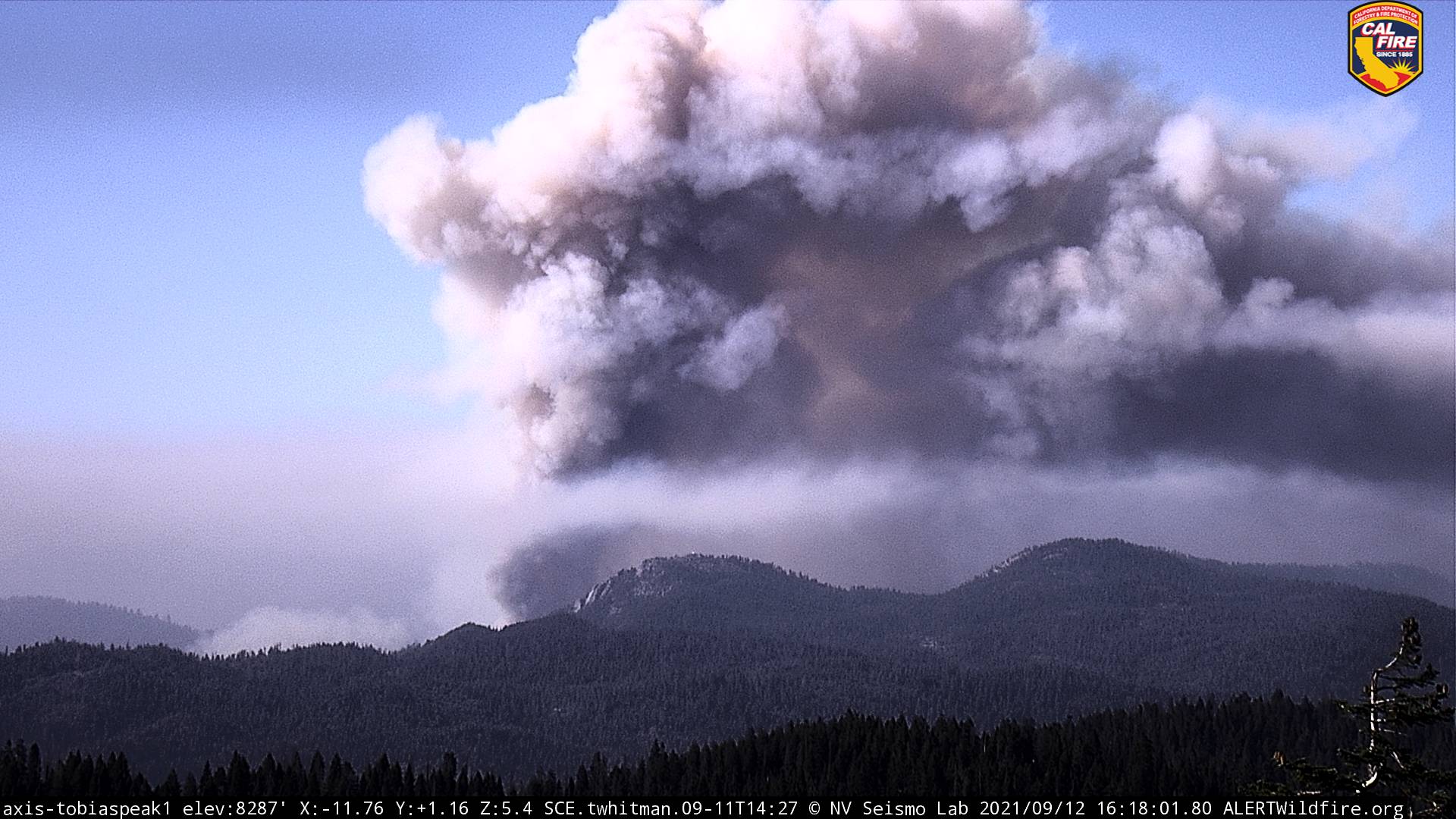
1,454 acres this morning. Significant possible expansion of the footprint based on Inciweb update. All Redwood groves in the area, along with Mule Peak lookout expected to be impacted. Looks like resources are timing out and this will have an impact on suppression activity. See bold type at the bottom. Not promising. From Inciweb:
Additional operational resources will be needed to make progress on this incident. As the incident continues to grow due to dry fuels and lack of resources more communities are being threatened by the fire spread. These communities include Camp Nelson to the North, Ponderosa to the Northeast and Johnsondale to the Southeast of the fire. These communities all have limited routes of egress and would require advance notice to evacuate safely. The Mule Peak lookout has a high likelihood of being impacted by the fire in the next 24 hours and a low probability of survival. Two high value Giant Sequoia Groves are being impacted by the fire and include Peyrone Grove, South Peyrone Grove numerous others including Red Hill Grove, Long Meadow Grove, Parker Peak Grove, North Cold Springs Grove and Trail of 100 Giants remain threatened. Major historical sites that are threatened include the scatted logging camps and mill sites and the Redwood Corral and associated structures. Additionally IA resources assigned from other fires will be timing out over the next 2 days leaving the incident with only one Type 1 Crew and two Type 2 Crews on 9/15. Without replacement crews and the additional critical resources requested by the incident has the potential to become a massive incident.

We will be losing these critical resources just as a trough of low pressure brings stronger and gustier winds over the fire area later in the week.

12 Likes