
State ID: CA
3 letter designator: TGU
Fire name: REDBANK
Location: 40°07’11.9"N 122°38’24.7"W
Reported acres: 2-3
Rate of spread:
Report on Conditions:
Structure threat:
Resources:
Hazards:
Weather:
Radio channels:
Scanner link:
Webcam link:
Agency Website:
From Q&A NorCalscan
TGU Red Bank - up to 10 acres now MROS. Two S2’s committed, requested a Type1 tanker, 2nd copter. Retardant on the eastern flank, chewing into the retardant. Quite a while still for ground resources to get in there. Brush and grass (1255pm edit: at 20 acres now, with expected afternoon winds this has potential for couple thousand acres now, chewing through the retardant)
SIXONENINE
AA-110 reporting a NEW fire several miles to the west @ 40 06.53 -122 47.34 - reports 10 acres in timber w/ moderate-dangerous ROS, slope & wind driven, potential for 1000+ acres/major incident. No name for this new fire yet.
2 Likes
PGE Hillcrest in Rancho Tehama (lower elev, SE of fire) 92F SE 10G20
PGE Ridge (lower elev, NE of fire) 93F, SE 11G18
Eagle Pk RAWS (south of fire, higher elev, midslope from valley to ridge) SE 11G21
1440 update
100 acres , fire moved from dangerous to critical rate of spread
Resource order
6 Charlies Strike Teams
12 crews
6 dozers
8 type 1 water tenders
4 4x4 water tenders
4 DIVS
1 Staging area manager
1 Heavy Equip Manager
4 Likes
318pm: fire half mile from reaching South Fork Cottonwood Creek. After that it’s into Pettyjohn area. Evacuation orders for the entire Pettyjohn Road corridor from SHF border down to 4 corners (intersection of reeds creek rd, pettyjohn, cannon rd and Pope Drive.)
The box is N of Sunflower Jeep Trail, S of Pettyjohn Road, E of Hammer Place, W of Masten Road (which is significantly east of fire)
4 Likes
335pm: Fire is 1500 acres
Evac ORDER for Pettyjohn Road. Extending the box to the north all the way to Hwy 36. Evacuation WARNING now for R Ranch and all secondary roads between fire and 36.
3 Likes
IC reports fire is now 1500 acres w/ moderate-dangerous ROS, ordering an additional: 6 type 3 engine strike teams (30 engines), 6 strike teams of handcrews, 6 dozers & 12 water tenders. IC has also requested a VLAT.
3 Likes
Listening to the AA transition, the AA stating he had an order in for 3 type 1 VLAT tankers (not sure if he meant 3 type 1’s and a VLAT or 3 VLAT’s). No divert on tankers. Using the aircraft to do structure protection.
1 Like
All the RAWS mentioned above are now gusting at 19-21 SE.
Fire has reached structures and residences at Pettyjohn Place. Defending as they can.
Order for 4 addl Type 1 tankers, a 2nd VLAT
6 Likes

Critical fire conditions occurring with structures becoming impacted shortly, having to withdraw engines from a structures as they can’t get Tankers in there to support them. Priorities are structure defense & personnel safety.
4 Likes
AA ordering
5 type 1 helicopters
5 type 2 helicopters for total of 8
3 type 3 with Helcos
2 Likes
437pm
2500 acres
spotting 1 mile ahead
evacs and structure defense in place
8 Likes
AA advising fire is moving quickly!!!
3500-4000 acres
7 Likes
2 charlies, 2 golf’s, 2 divisions, 2 lima’s, 1 staging manager for highway 36 contingency at Highway 36 and Vestal road.
2 Likes
Tanker 162 heavy off Fresno enroute.
1 Like
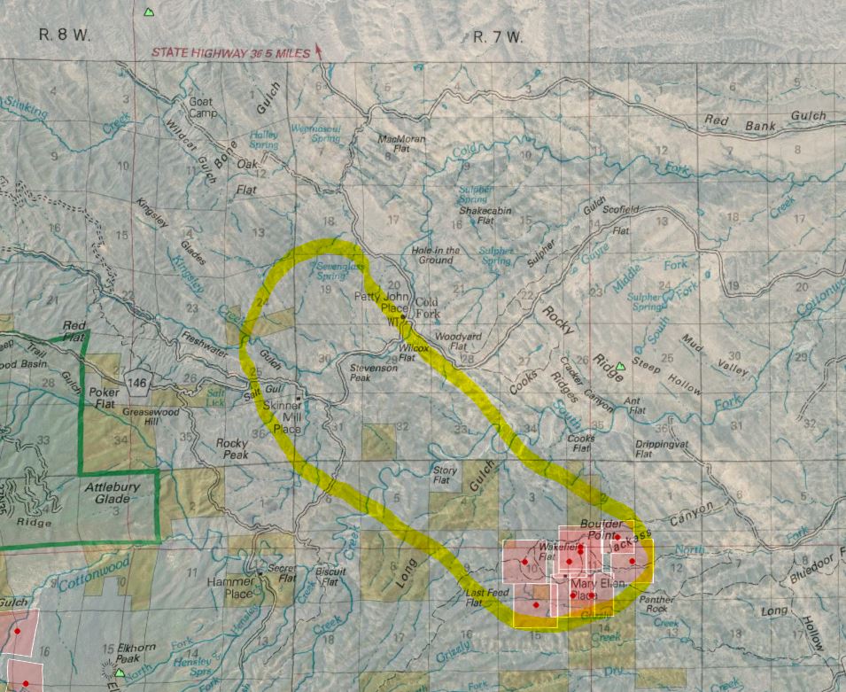
VERY humble attempt at sketching this out as of 5pm. Not my ideal battle station at work with office radios and notes and not in control of my online scanner.
On this map, the road heading north out of “Petty John Place” is Weemasoul Road. The road off that to the left going to Oak Flat and Goat Camp is Halley Grade Road. The road with red arrow “36 5 miles” is Vestal Road. Fire is still south and west of Vestal.
edit: it’s marching right up to the upper left of this map - Halley Grade and directly to R Ranch area (which is up off the map past “R 8 W”
14 Likes