
AA-240 ordering for tomorrow: 1 lead plane, 3 S-2 tankers, 4 large air tankers & 1 VLAT.
1 Like
CAL FIRE IMT-5 (Parkes) in command
CAL FIRE ECC Support Team #3 assigned
7500 acres
7% contained
Difficult access and steep terrain
Evacuations still in affect
Multiple resources on the road
2 Likes
AA placed the remaining few tankers on a hold due to no available lead plane over the incident or en-route. May give AA time to recon the SouthFire just to the west.
Which is the South Fire again?
SHF-South is just “up creek” from Red Bank fire - up the south fork of cottonwood creek. 4 miles fire edge to edge east-west. With the team in place, lots of rumors of South getting picked up by the team as well for lots of logistical/tactical reasons etc. It’s FRA where the fire started, but now is pretty equal FRA/SRA. And if the two join then, well, someone crossed the streams.
edit: just saw @captmack state Team 16 is taking the South fire.
5 Likes
Dispatched XSN2376C to this incident this morning, with 2 additional type 3 ST requests currently UTF. Fire Season has arrived on the North half of CA… BE SAFE, no acreage is worth a life!
8 Likes
If anyone gets the IAP links can you please post them? I scanner isn’t working For whatever reason so I’d love a good update with out department out on the line.
I believe this is the map some folks are looking for. I didn’t see where it might have been previously posted. Stay safe!
20190907_RedBank_IR TopoMap.pdf (2.0 MB)
3 Likes
Topo Map from last night’s flight shows it at 8000 acres.
Another topo map of the Red Bank and nearby South Fire.
1 Like
Thanks, just getting ready to post the combined Red Bank and South fires but you are quicker.
Per Cal Fire Twitter:
#RedBankFire off Hammer Loop Road and Petty John Road, West of Red Bluff in Tehama County is 7,754 acres and 9% contained. Evacuation warnings and road closures in place.
1 Like
If you’re local to the fire…
Command is CDF CMD 7 of Inskip Peak
Air Ground CDF Tac 18
Ground Tacs CDF Tacs 24-28, 36, 37
Air Tactics FM 169.4875
Rotor Victor 132.275
I’ve got Command, A/G and Air FM on priority on scancal.org/live.html
1 Like
Heard the airtac a little bit ago during relief say the fire looks much better today than yesterday…good news
2 Likes
A slop in Charlie (Hammer Loop) occurred over the main line about an hour ago. Couple acres into a little more. Air Attack ordered an ATGS qualified helco up from Helibase immediately to the fire as he was timing out. They ended up getting a few drops in on ridge above the slop and were going to pretreat the road up top to give the ground a fighting chance, except Helibase sent the wrong guy out. Cancelled the entire fixed wing airshow because of that (slow clap). So Charlie will get what they get. Heat got knocked down and it’s behaving a bit, but will be some work to clean up the slop.
SHF-South has a NW wind shift on it now, pushing south over the south side of Cottonwood Creek - not where they want it.
5 Likes
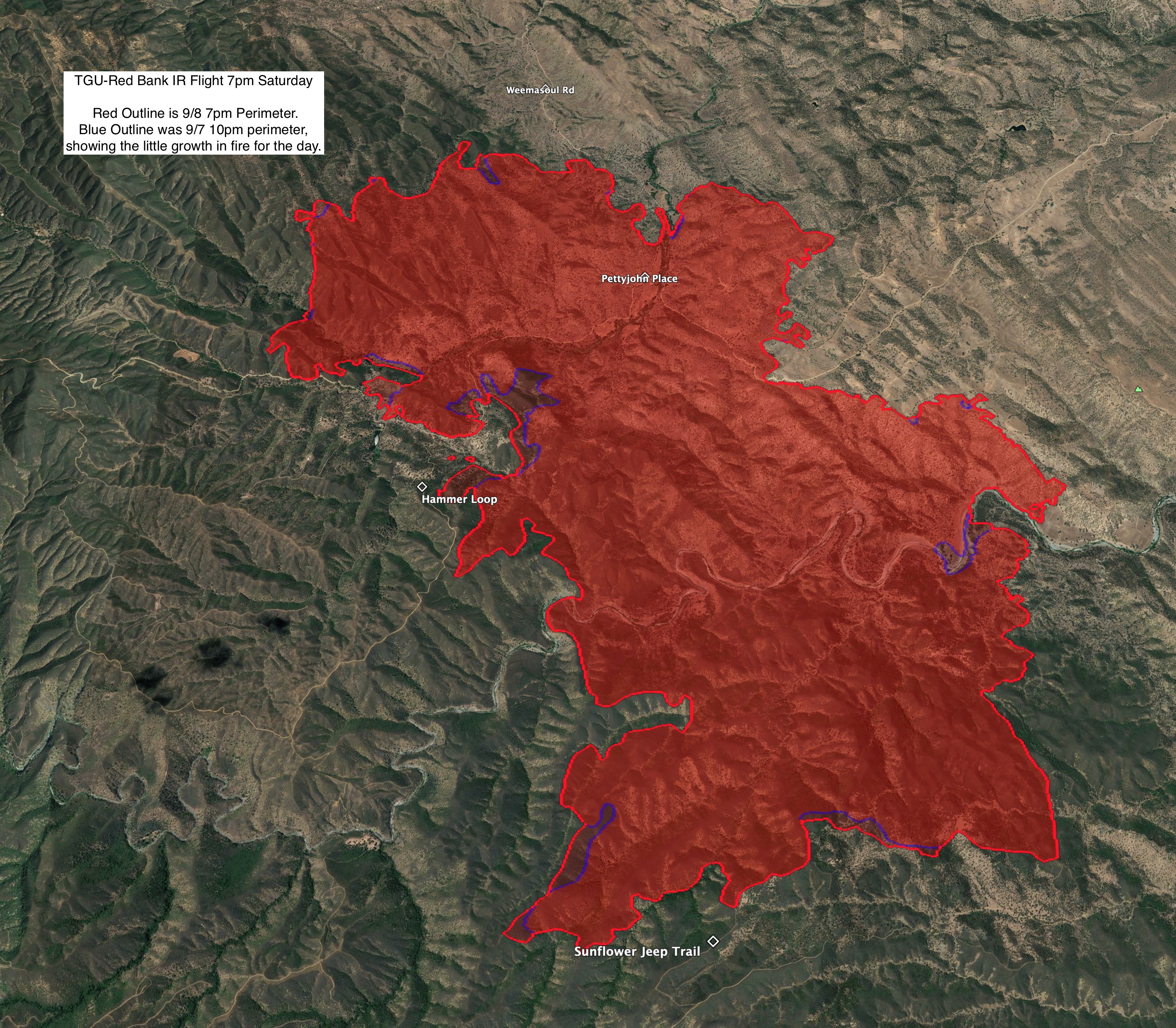
I think a picture is worth a 1000 words here. The fire did basically 218 acres of nothing today. VERY strong work out there! Hold the lines with the wind, keep that slop in check by my “Hammer Loop” label, and you’re set.
5 Likes
Cal Fire Twitter:
#RedBankFire off Hammer Loop Road and Petty John Road, West of Red Bluff in Tehama County is 8,838 acres and 20% contained. Evacuation warnings and road closures in place.
3 Likes
Cal Fire Twitter:
#RedBankFire off Hammer Loop Road and Petty John Road, West of Red Bluff in Tehama County remains 8,838 acres and 75% contained.
1 Like
9/12/19 @ 0700: CA-TGU Red Bank Fire: 8,838 acres brush, 90% contained. Crews continue mop-up and suppression repair.
This one is 100% contained.
1 Like