CA-YNP-Washburn (Contained)

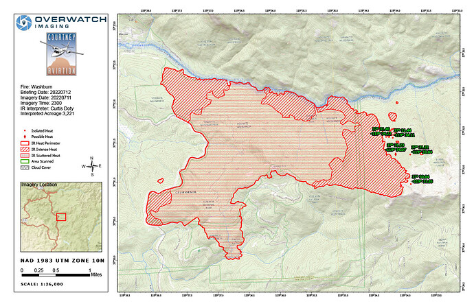
From the IRIN.
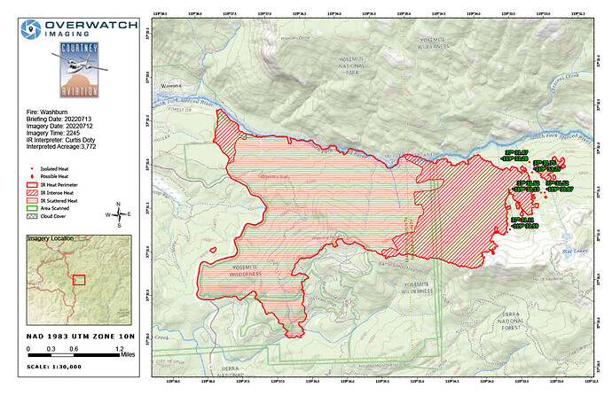
IR Interpreted size as of 7-11-22 at 2300 was 3,221 acres. Growth last period was 881.

Weather was clear over the incident with light smoke, providing good georectification and visibility. Previously reported spots North across the river in Div Tango had negligible heat. All new spots in Div Yankee attached (in the kmz).

4 Likes

From OSC2 Matt Ahearn’s briefing last night.

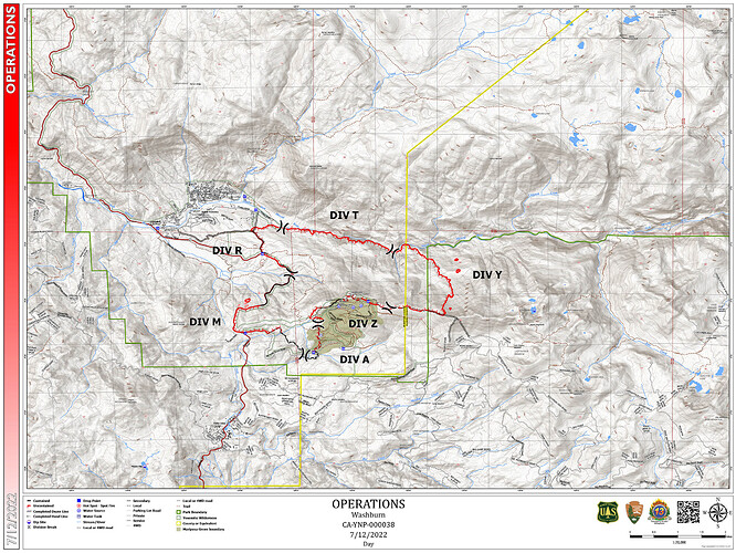
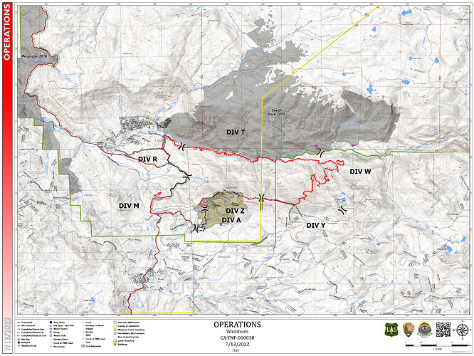
DIVS M, fire didn’t hit Hwy 41 that hard. Using it as a control feature and it is working well. Picked up several spot fires and they are lined. Bringing fire to the road as necessary.

DIVS R, using 41 and bringing fire along it. Then using Studhorse around DP 30, down to the South Fork of the Merced River (SFMR) around DP 35. Currently bringing fire down the line and it is working well.

DIVS, Structure Defense Group in the community of Wawona. preparations mostly on the south side include some dozer line, sprinkler kits, hose lines, engines.

DIVS T, using a couple of hotshot crews on a night mission (only) to brush the SFMR. One spot fire north of the SFMR in Tango. Lined by El Dorado and contained. Expecting more spots and monitoring by air.

DIVS Y, using 6 HS crews to cut out the ridge system from Wawona Pt., out to a rocky ridge and tie it in to Star mine area. Fire has bumped it in multiple places but the ridge is holding. Lots of retardant. Lots of planning on how to use a ridge, trail, or other method to try and tie it back into the SFMR. Lots of pending orders are waiting for the plan to be built and fully developed.

Mariposa Grove, fire has only backed into the Mariposa Grove (MG) in places, and as a lower intensity. Hand line across the top in DIVS Z. The Ridge line is the primary control line and has been holding. Do not expect major challenges though as the fire side slopes on the north side (pushes to the east) of the ridge it presents challenges to MG.

Beledo Cabin is being prepped and wrapped.

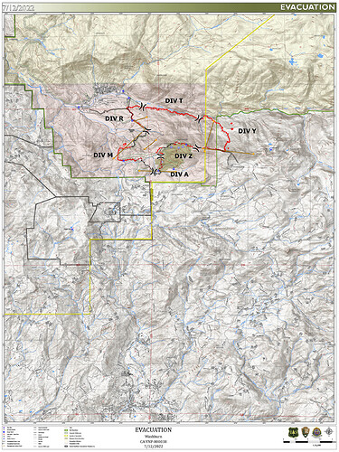
Wawona Community, still under an evacuation order. Working on 41 trying to snag and safe it.

The activity that is being seen is the fire flanking and side sloping and then running to the top of the ridge in DIVS Y, so essentially it’s a slope driven fire that (IMHO) runs to the top and then loses its power and is then influenced by the SE ridge top winds that push it back, so it’s hanging on the ridge, with help.

22 Likes

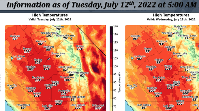
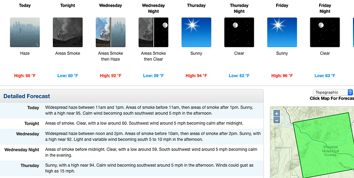
NWS Hanford Tues: The SREF is indicating a slight chance of afternoon showers and thunderstorms over the higher elevations of the Sierra Nevada today. The ridge will weaken a bit on Wednesday allowing for temperatures to cool a bit from today’s readings.

The ridge is progged to rebound and strengthen over CA as it builds back westward on Thursday and Friday. This may result in afternoon temperatures approaching dangerous levels by Friday.


4 Likes

Ops Map (resized), IR and Evac Zone Maps 7/12/2022:

8 Likes

Firewatch 51 enroute for mapping mission. Update report should follow.

3 Likes

EDIT UPDATE: @09:13
Firewatch reports no heat on spot over the line off hwy41 from yesterday, no spots on north side of merced river. Mariposa grove lines holding in Div.Y. Fire progressed out to Mount Raymond. Did not say acreage. Head of fire does not look good.
Helco up and starting the copter operations.

How quick it changes today…
EDIT UPDATE @10:16 AA52 is enroute to assess tanker use. Helco shut down copters due to smoke out conditions. Copters could not safely navigate the edge and see targets.

AA52 ordered two type 1 LAT’s to the fire to extend the ridge line retardant line above Mariposa grove, Bieldo cabin out eastward towards Star Lakes (dip site). Spike camps are moving into meadows below that ridge.

EDIT UPDATE @ 12:45 AA52 off the fire tankers released line completed. DeRosa hand crew is creating a hand line where the tankers dropped. Div. Y.

10 Likes

Looking at the camera it looks like they are firing in division Y, smoke coming up east of the big column along the ridge.

4 Likes

5 Likes

Tanker 137 dropping on the timber stringers on Raymond mountain, big granite face on the ridge will be a real good fire line.

4 Likes

Believe I heard AA/Helco discuss that the crews will be engaging a line building operation from spike camps to the south to proceed off Mount Raymond, Star Lakes to Iron Creek, north to Merced River.
To complete the box. Fire is active but staying to the ground, consuming all ground fuels.

EDIT UPDATE @ 16:44 Firewatch 51 reports 3717 acreage with AA.

8 Likes

I did a search on Twitter and yosemitefirewatch does not exist. Please verify a correct site, thanks.

2 Likes

https://twitter.com/YosemiteFire?s=09

1 Like

XSJ 4177C enroute

6 Likes

https://twitter.com/YoseFirewatch

4 Likes

3843 acres.

4 Likes

Per 209:
Outstanding Resource Needs: (as of PM 7/12) 4 COMTs; 4 RADOs; NIFC Repeater System; 1 Type 1 Road Grader; 2 Type 2 and 2 Type 3 12 hours: Excavators with thumbs; 2 Feller Bunchers; 2 Log Loaders; 2 Dozers; Type 3 and Type 6 engines; /Type 2 Crews; UAS; Continued aviation support

1045 Personnel Assigned
Projected Final Incident Size: 5,500 acres
Projected Containment: 7/31

Maps:
Ops Map (resized) & IR Maps 7/13/2022:

7 Likes

3 Likes

Helco and Firewatch 51 said the only concerns this morning is some fire creeping into the retardant on Mount Raymond Div.Y and crews are engaging directly on the spot inside the line between main fire in Div.T. No other concerns for heat around the remainder of the fire lines.
Verbal update on acreage 3981? 3891?
Reduced burning conditions this morning.

7 Likes

Air tanker Incident

9 Likes
7 Likes