Recap from the last smart firefighting roundtable on TAK and UAS.
TAK job in Colorado.
Good article on TAK with STRATO.
TAK mention and great discussion.
Spotify
https://open.spotify.com/episode/2eDqxGblyRYlnw6PS7NJbz?si=gr4t3Cp1So2mc1dciP3ySg
Website video link
I put together a new video on how to use orthomosaic imagery in ATAK using the Palisades fire as an example.
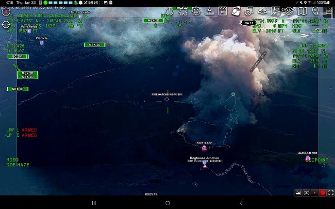
The tools man I always go back to the tools in TAK. Shot of the day FIRIS live video with SmartCam3D plugin with augmented reality overlays and showing the range and bearing line from fire to infrastructure. What other app offers those tools to a on the ground div, ops, IC?
If I set up a TAK-Server for this community to use would folks be interested in using it for testing/evaluation?
It would be deployed with the “channels” feature.
There would be a “public” channel and you tell me if you want to be in the public channel. You would have to be mindful that if you have the public channel turned on and you have your location service turned on, others in that channel will see your location.
Each group/agency etc could have their own channel for their own internal use.
Think of channels just like radio frequencies. If your on that channel you can listen and talk. You can be in multiple channels at the same time in TAK.
The TAK-Server can set who has access to specific channels on a per user basis so basically you just tell me I want a channel for my group/agency, I will make that channel and yes or no I want to be part of the public channel or not. We could even make GACC specific public channels.
When time permits I could push Data Packages to the TAK-Server for download into ATAK for large fires, or once folks get comfortable with it they could do it themselves.
If you post to the public channel everyone has access to that data package for the shift etc.
Let me know whatcha all think.
Definitely — I know we obviously have a different situation than our friends in Colorado here in the State With the Bear Flag, but it’s hard not to be at least a weeeee bit envious of CoTAK…
Ok its in process, if people want to play just dm me.
Hey all this is not just TAK stuff but anyone who is using the CAL-FIRE AIR INTEL network kml in ATAK or Google Earth there is now USFS AA-51 data in there.
I am pretty damn stoked on this.
I noticed midway through the Eaton fire the USFS were adding it to the esri feature service which is a mash up of FIRIS, CAL-FIRE perimeters. I did not see anything for awhile of course we got rain but mid may started seeing data so it appears they are adding their missions to this public repo.
Kudos to the USFS for moving this direction.
The only issue I have right now is the KML network link is bringing in all the data as of now but working on getting it restored to just publishing the last 72 hours.
https://tinyurl.com/cal-fireairintel
It also has in the esri feature service a couple daily wildfire perimeters from the NIFC that I will parse out. This is really meant for realtime fire perimeters from airborne intel.
If you want to use the esri feature service it is at.
They state of technology is just incredible. FIRIS gets on scene, starts to transmit live video. In ATAK i am able to use the SmartCam3D plugin and actually trace the fire in the video and it transmits that location onto the ATAK map. This is hard because well I cant tell the sensor operator to hold still so as they are operating the camera I am doing my best. This accuracy aint bad compared to the KML that comes off their mapping platform. The difference? I had this immediately. FIRIS perimter in green, my hand drawn off the video I did in 10 seconds of starting the video.
When I get home I will show a video of me doing this live. I will explain some of the nuance of oblique imagery but man this is just so good.
Any Nova users on here? They just finished a TAK integration that is pretty cool. As I helped them through this I discovered that Nova runs pretty well on a Plus size Samsung Galaxy tablet as well. You can litteraly connect your aircraft direct to the tablets and do all your mapping uploads and then bring it into TAK. If you are on a desktop the integration for TAK-Server is pretty clutch.
I want to add that the NOVA team was super receptive to adding a TAK Server integration and me asking to rotate the symbols. I said all we need really is the break icons to be rotated and they banged this out to have different orientations. This option to build a geo pdf is free. I think its a great fit for that first IAP/OPS map. Either you caught the fire and you dont need classic GISS support or its going big but you dont have your GIS team in place yet. You can bang out that first IAP map that is georeferenced. So it has a qr that can be used with Avenza, you got ATAK, iTAK yada yada you have all your bases covered.