AZ lightning fires 2022???

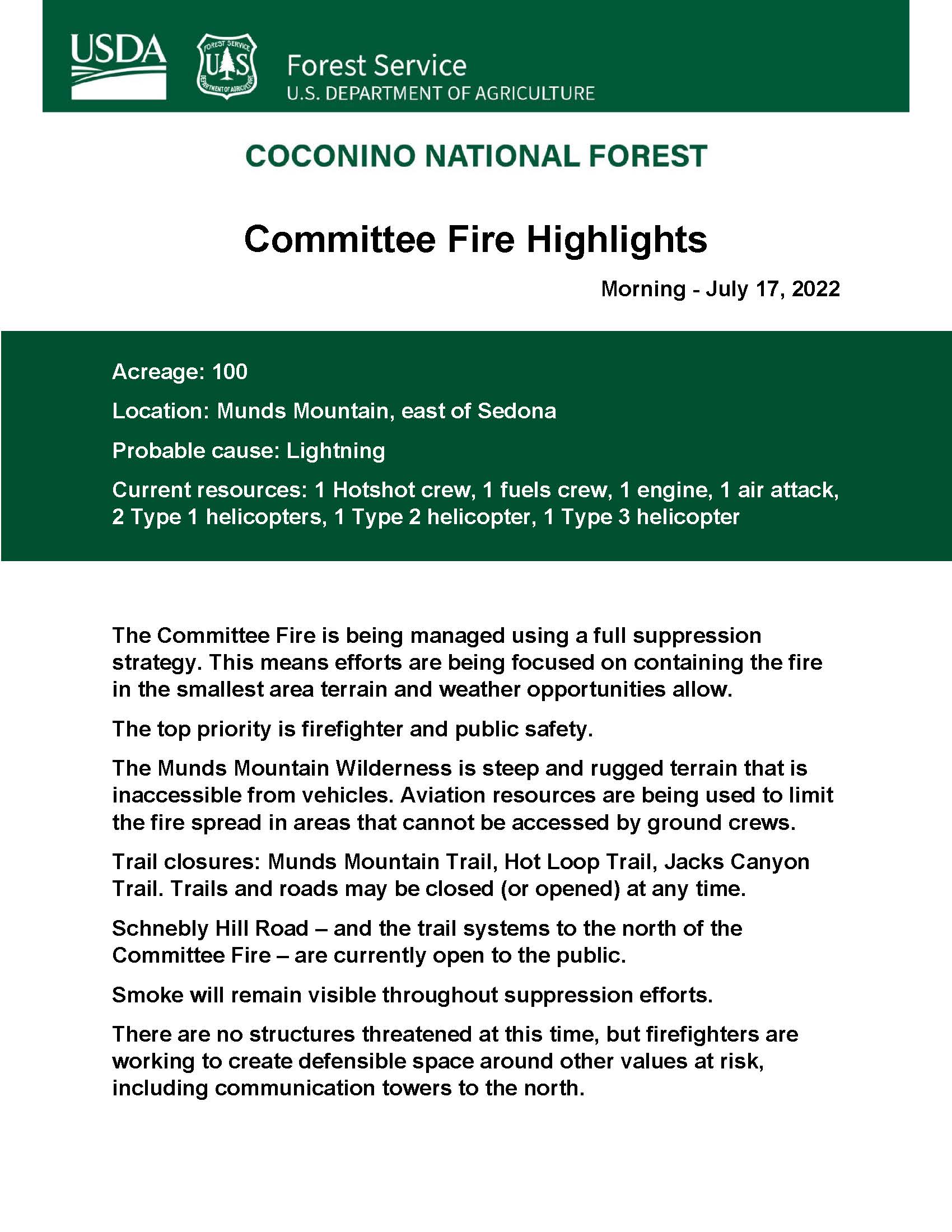
KINGMAN AREA WILDFIRES UPDATE -10 p.m. 7/16/2022
Recent monsoon storm activity and lightning has ignited at least 6 wildfires in the greater Kingman area. Due to the number of fires and continued lightning activity, fire crews will prioritize and suppress fires with greater and more immediate values at risk. Fires in remote, inaccessible locations may be monitored while firefighters work to contain high priority fires.

As of 9:00 p.m. on 7/16, BLM firefighters are responding to assist AZDFFM with a new fire near Wikieup. No other information yet.

[Fires listed in order of discovery.]

Fire Name: Wagon Wheel Fire
Location: 15 miles NW of Wikieup, AZ in Hualapai Mountains
Containment: 100%
Discovery Date: 7/15 at approximately 7:00 p.m.
Fire Size: 10 acres
Current Fire Behavior: Fire is contained and in patrol status
Strategy: Fire crews were able to access and contain the Wagon Wheel Fire on 7/16.

Fire Name: Pine Peak Fire
Location: On Pine Peak in Hualapai Mountains, approximately 20 miles southeast of Kingman
Containment: 0%
Discovery Date: 7/16 at approximately 9:00 a.m.
Fire Size: estimated at 10 acres 3:00 p.m. on 7/16
Current Fire Behavior: Fire is spreading slowly in ponderosa pine fuels and occasionally torching in oak brush.
Strategy: Fire is in extremely remote and rugged terrain with no road access. Firefighters are currently assessing challenges of weather and access, to determine best ways to achieve containment.

Fire Name: Dean Fire
Location: Hualapai Mountains near Getz Peak
Containment: 100%
Discovery Date: 7/16 at approximately 12:30 p.m.
Fire Size: 0.25 acre
Current Fire Behavior: Fire is contained
Strategy: Fire crews were able utilize a Type 1 Helicopter supported by ground units to quickly contain the fire. It was a high priority fire due to proximity to communication facilities on Getz Peak and nearby communities of Pinion Pines and Pine Lake.

Fire Name: Cow Fire
Location: Hualapai Mountains on Granite Peak, approximately 30 miles southeast of Kingman
Containment: 0%
Discovery Date: 7/16 at approximately 2:30 p.m.
Fire Size: approximately 4-5 acres at 3:00 p.m. on 7/16
Current Fire Behavior- Fire is spreading slowly in ponderosa pine fuels with some chaparral.
Strategy – The Cow fire is in extremely rugged terrain with no road access. Firefighters will assess containment opportunities and access and utilize aircraft to monitor. New fire starts may take priority over the Cow Fire due to the remote location and limited values at risk.

Fire Name: Box Fire
Location: approximately 1 mile south of Kingman
Containment: 100%
Discovery Date: 7/16 at approximately 4:00 p.m.
Fire Size: 0.1 acre
Current Fire Behavior: Fire is Contained
Strategy – Helicopter supported by ground units were able to access and contain the fire quickly.

Public Information Officer: Dolores Garcia, 602-828-8734, available 8 a.m. - 5 p.m. variable relative to fire activity.

City of Kingman Fire Department Mohave County Parks Department Mohave County Sheriff’s Office Mohave County Division of Emergency Management Pinion Pine Fire District

2 Likes

NEW -#CommitteeFire #AZ #AZCOF bit.ly/3coeYPm Committee Fire: The Committee Fire was reported at 12:20 p.m. Friday, July 15. It is located on the back side of Munds Mountain, east of Sedona. Smoke will remain visible during suppression efforts. It was likely caused by lightning.

1 Like

We have been hammered the last few days with heavy lighting with the associated smokes and occasional (less than) 10-acre fire in the Ponderosa’s…

What we are finding is that, regardless of the amount of precept or humidity in an area, we are still getting working vegetation fires. Bottom line, keep your SA up, especially in the Northern Arizona woods. This has been a very different fire season for many.

Stay safe and hydrate.

Carry On.

3 Likes

Kingman Area Wildfires - July 17, 2022, Morning Activity Update: Helicopter flew over all known fires just after 10 a.m. Smoke was visible on 2 fires. Both active fires appeared to have received rain from the storms that passed through the area last night. Aircraft is currently being used to monitor.
Fires in remote, inaccessible locations may be monitored while firefighters work to contain high priority fires.

Fire Name: Pine Peak Fire
Location: On Pine Peak in Hualapai Mountains, approximately 20 miles southeast of Kingman
Containment: 0%
Discovery Date: 7/16 at approximately 9:00 a.m.
Fire Size: Mapped at 9.2 acres 7/17
Current Fire Behavior: Fire is spreading slowly in ponderosa pine fuels and occasionally torching in oak brush.
Strategy: Fire is in extremely remote and rugged terrain with no road access. Firefighters are continuing to assess challenges of weather and access and determining safest ways to achieve containment. Aircraft will be used to monitor.

Fire Name: Cow Fire
Location: Hualapai Mountains on Granite Peak, approximately 30 miles southeast of Kingman
Containment: 0%
Discovery Date: 7/16 at approximately 2:30 p.m.
Fire Size: mapped at 2.5 acres 7/17
Current Fire Behavior- Fire is spreading slowly in ponderosa pine fuels with some chaparral.
Strategy – The Cow fire is in extremely rugged terrain with no road access. Firefighters continue to assess containment opportunities and access and utilize aircraft to monitor. New fire starts may take priority over the Cow Fire due to the remote location and limited values at risk.

Fire Name: Big Sandy Fire [Arizona Department of Forestry and Fire Management is the lead agency on this incident]
Location: south of Wikieup
Discovery Date: 7/16 at approximately 9:00 p.m.
Fire Size: Mapped at 75 acres
Current Fire Behavior: Fire was active into the night. Multiple structures threatened & 20 people evacuated.

BLM Photo 7/17 Recon of Cow Fire

1 Like

Kingman Area Wildfires - July 19, 2022, Morning Activity Update: Area firefighters remain active with new and ongoing wildfires caused by lightning from passing, monsoon thunderstorms in the greater Kingman area and southern Mohave County. Increased humidity in the area has helped to keep fire activity moderate, but the area is entering a drying period where fire activity and smoke may increase, and new fires from holdover lightning strikes may become apparent.

The most active of the fires is the Pine Peak Fire. Smoke from the Pine Peak Fire will be visible to surrounding areas, including Yucca, Wikieup, and at times Kingman.

Fires in remote, inaccessible locations continue to be monitored while firefighters work to contain high priority fires adjacent to communities.

Fire restrictions remain in effect through the BLM’s Colorado River District as the fire danger continues to be high and moisture from monsoon storms has not been widespread across the area.

The following fires are listed in order of discovery date. Fires that have been fully contained for more than 24 hours and no longer active have been removed from the update.

Fire Name – Pine Peak Fire
[Information on Inciweb: Pine Peak Fire Information - InciWeb the Incident Information System ]
Location – Pine Peak in Hualapai Mountains, approximately 20 miles southeast of Kingman
Containment – 0%
Fire Size – Estimated at 56 acres 1000 on 7/19
Discovery Date – 7/16 at approx. 0900
Cause – Lightning
Current Fire Behavior – Fire continues to spread slowly in ponderosa pine fuels with occasional
torching in oak brush. Dry and warm weather may increase fire activity and smoke production through Friday. Updated mapping will occur later this morning.
Strategy – Due to the extremely remote and rugged terrain, this fire is in a confine /contain
strategy. Firefighters will continue to scout containment opportunities and utilize aircraft to monitor. New fire starts may take priority over the Pine Peak Fire due to the remote location and
limited values at risk on this incident. Smoke from the Pine Peak Fire will be visible to surrounding areas, including Yucca, Wikieup, and at times Kingman.

Fire Name – Cow Fire
Location – Hualapai Mountains on Granite Peak, approximately 30 miles southeast of Kingman
Containment – 0%
Fire Size – 10 acres at 1000 on 7/19 Discovery Date – 7/16 at approx. 1430
Cause – Lightning
Current Fire Behavior- Fire is spreading slowly in ponderosa pine fuels with some chaparral. The fire had minimal activity yesterday.
Strategy – Due to the extremely remote and rugged terrain, this fire is in a confine /contain strategy. Firefighters will assess containment opportunities and access and utilize aircraft to monitor. New fire starts may take priority.

Fire Name – McCarrel Fire
Location – Hualapai Mountains East of Blake Ranch Road, approximately 15 miles east of Kingman
Containment – 100%
Fire Size – 0.1 acre
Discovery Date – 7/17 at approx. 1620
Cause – Lightning
Current Fire Behavior – Fire is contained

Fire Name – Yellow Flower Fire
Location – Hualapai Mountains 1.5 miles south of Lazy Y/U subdivision, approximately 6 miles southeast of Kingman.
Containment – 80%
Fire Size – 3 acres at 1700 on 7/18
Discovery Date – 7/18 at 1500
Current Fire Behavior – Fire is burning in desert scrub and brush; some interior heat in heavier fuels.
Strategy – Firefighters used a heavy airtanker drop and helicopter with bucket to deliver water to support ground resources, quickly stopping fire spread and eliminating threat to nearby
subdivision.
Firefighters plan to complete mop-up today.

Information Contact - BLM, Colorado River District – Kingman Field Office
Media Contact: Rodney Crum, Colorado River District Public Affairs Specialist rcrum@blm.gov, (928)
889-1057
Photo: BLM/Pine Peak Fire
Arizona Department of Forestry and Fire Management Pinion Pine Fire District Mohave County Parks Department Mohave County Division of Emergency Management Mohave County Sheriff’s Office City of Kingman Fire Department Arizona Game and Fish Kingman Hualapai Mountain County Park

1 Like