State ID: AZ
3 letter designator:
Fire name: Presumido
Location: Pima County, 10 miles N/NW of Sasabe
Reported acres: 850
Rate of spread:
Report on Conditions: wind driven
Structure threat: none
Resources: hand crews, engines, VLAT
Hazards:
Weather:
Radio channels:
Scanner link:
Webcam link:
Agency Website: https://dffm.az.gov/
#PresumidoFire, approx. 10 mi. NW #Sasabe w/n Presumido Peak #PimaCounty. Fire discovered Sat. pm & determined to be human-caused; est. 150 acres. Morning flight to get better size-up due to areas of inaccessibility. At this time, no structures threatened. #AZFire #AZForestry https://twitter.com/azstateforestry/status/1508113332313620480/photo/1
The wind-driven #PresumidoFire NW of Sasabe has grown to 850 acres & has moved onto the Tohono O’odham Nation. Additional resources have been requested including a Very Large Air Tanker (VLAT) to help slow progression onto the nation. The fire has been very active all day & remains visible to multiple communities. #PimaCounty #AZFire #AZForestry
Update on Presumido Fire in AZ, Tankers 03 (LAT) and Tanker 910 (VLAT) 1 T3 helo, Lead 55, and multiple ground resources are on the scene. This marks the first VLAT drop to our knowledge in the US this year on a fire.
~1945-#AzFire #PresumidoPeakFire. Listed as 2000Acres https://twitter.com/CCFirenIncident/status/1508276975621660676/photo/1
2045: Map of fire from #FIRMS (est’d) #PresumidoPeakFire https://twitter.com/CCFirenIncident/status/1508290005201956866/photo/1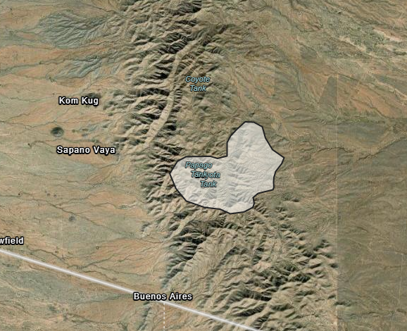
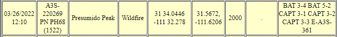
#PresumidoPeakFire remained active overnight on west & south flanks, Fire is 2,000 acres, approximately 20 miles North/North West of #Sasabe. Ground crews & aircraft working to protect power infrastructure & grazing allotments nearby. Red Flag Warning in effect today. #AZForestry #AZFire #PimaCounty
https://www.facebook.com/100064731036882/posts/340955111405521/

2 Likes
Tuesday March 29 AM Update: #Presumido Peak Fire
Overnight the fire received intermittent showers which helped decrease fire activity significantly. Today, crews continue to secure the perimeter, using natural features and trails, as they take advantage of Tuesday’s cooler temperatures. The fire remains at 2,600 acres, but will be mapped again today. The fire is expected to be larger due to Monday’s fire behavior and activity, including wind-driven runs. At this time, 69 personnel remain assigned to the incident, including hand crews, engines, water tenders, and aircraft. The human-caused fire started Saturday afternoon within Presumido Peak, 20 miles N/NW of Sasabe. #AZForestry #AZFire #PimaCounty
2 Likes
Wednesday, March 30 Update: #PresumidoPeak Fire
Fire command was able to fly the fire this morning and report that containment lines currently in place are holding and minimal smoke is showing within the interior of the fire. Today’s weather is helping firefighters with suppression efforts due to high daytime humidity levels. The fire is approximately 4,000 acres with 20% containment. The human-caused fire started Saturday, March 26, north/northwest of #Sasabe. Nearly 100 personnel are assigned to the fire, including hand crews and engines. #AZFire #AZForestry

1 Like
#PresumidoPeakFire Today crews were able to get the fire up to 70% containment with minimal smokes visible, with the use of aircraft and gps the fire was mapped to be 2,591 acres. The fire will be transiting from a type 3 to a type 4 incident in the morning.#AZFire #AZForestry https://twitter.com/azstateforestry/status/1509372359026757633/photo/1
2 Likes
#PresumidoFire - crews patrolling & mopping up areas & taking advantage of decreased fire behavior to add add’l containment lines. Due to more accurate mapping, size reduced to 2,591 acres. 70% containment. Human-caused fire started Saturday, N/NW of #Sasabe. #AZFire #AZForestry https://twitter.com/azstateforestry/status/1509638615541825547/photo/1
1 Like