State ID: AZ
3 letter designator: SON
Fire name: Elgin Bridge
Location: Elgin, AZ 31.66294, -110.52190
Reported acres: 1500
Rate of spread: fast
Report on Conditions: fast moving through grass and brush
Structure threat: yes with evacuations in progress
Resources:2 VLATs, T910, T914, 4 LATs, T03, T16, T40, T137, 2 ATS3 (SEATs), 1 FWLP (Lead) and 1 FWAA (Air Tactical) ordered / assigned.
Hazards:
Weather:
Radio channels:
Scanner link:
Webcam link:
Agency Website:
New start AZ - Elgin Bridge Fire (AZ-SON). Discovered 5/23. In Elgin AZ (31.66294, -110.52190). 1500 acres 2 VLATs, T910, T914, 4 LATs, T03, T16, T40, T137, 2 ATS3 (SEATs), 1 FWLP (Lead) and 1 FWAA (Air Tactical) ordered / assigned. This is a fast moving grass and brush fire. We are getting unconfirmed reports that acreage may possibly be as high as 4000 acres already, but we are still striving to confirm, and will update as we can confirm.
As of 1:30 pm, and per Santa Cruz County Sheriff’s Office - all residences along Mustang Ranch Road are being evacuated.
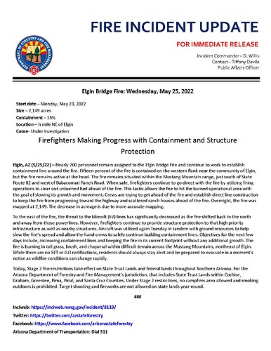
#AZForestry has taken command of the #ElginBridgeFire, approximately 1/2 mile northeast of Elgin. Structures are threatened with evacuations in progress per the Santa Cruz County Sheriff’s Office. The wind-driven fire is moving to the northeast through heavy grass and making a run up Mustang Mountain. Per Air Attack fire is estimated to be 1,000-1,500 acres. The fire is active on all sides. Engines, hand crews, and aircraft engaged. #AZFire
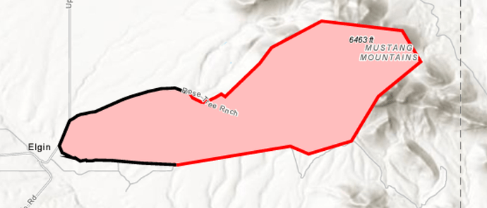
The #ElginBridgeFire grew to about 4,000 acres today, fueled by winds and dry vegetation. The fire made a wind-drive run into the Mustang Mountain range where it’s currently situated. Per the Santa Cruz County Sheriff’s Office, 11 residences along Mustang Ranch Road remain in GO status. There are multiple values at risk including, kV lines on the eastern side of the fire, grazing lands, and structures. The fire is burning in a semi-remote area, just south of SR 82, and 1/4 mile northeast of Elgin. Approximately 160 personnel are assigned to the fire, including hand crews, engines, water tenders, and aircraft. Crews will work overnight to continue with suppression efforts. The fire increased in activity Monday night and the glow of the fire may be visible to the communities of Sonoita, Elgin, and Whetstone.
Stage 2 fire restrictions go into effect on state and federal lands on Wednesday. Fuels are unseasonably dry in southern Arizona and any ignition source into the dry fuel bed can ignite fast-moving wildfires*
#AZFire #AZForestry #SantaCruzCounty
https://www.facebook.com/100064731036882/posts/380200184147680/
Update The #ElginBridgeFire decreased in size due to more accurate mapping. The fire is currently at 2,149 acres and 15% containment The fire remains situated within the Mustang Mountain range, just south of State Route 82 and west of Babacomari Ranch Road. #AZFire #AZForestry
30% contained per AZ Department of Forestry this morning. Still 2149 acres
Firefighters working the #ElginBridgeFire have it 73% contained with no change in acreage. Today they are working to tie in any unsecured line that remains on the northern and northeastern flanks of the fire. They will also continue patrolling the perimeter and checking for any hot spots or smokes within the fire’s interior. Some resources are being released so they can be made available should any new starts occur over the holiday weekend. So please, do your part - help us out to prevent fires. Stage 2 fire restrictions are in effect across the state on both State Trust Lands and federal lands. #AZFire #AZForestry #SantaCruzCounty
#ElginBridgeFire: fire endured strong winds today, but lines holding & crews patrolling perimeter. Fire is 95% contained; 2,149 acres. More resources released to provide IA for any new starts over next few days. Fire started Mon. NE #Elgin in #SantaCruzCounty #AZForestry #AZFire
The #ElginBridgeFire is 100% contained at 2,149 acres. Fire investigators have ruled the fire was human-caused, undetermined; meaning they could not locate an ignition source to give a definite and accurate cause. The fire started Monday, May 23, about a 1/4 mile northeast of Elgin in Santa Cruz County. #AZFire #AZForestry

