Concow and Bloomer cameras showing a fire near the Cherokee Loop, here.
https://goo.gl/maps/pDi9g36DiguJvNVW8
http://www.alertwildfire.org/shastamodoc/index.html?camera=Axis-Concow&v=81e002f
http://www.alertwildfire.org/shastamodoc/index.html?camera=Axis-BloomerLookout2&v=81e002f
AA503, T94 and 95 worked their way between active storm cells from Redding and over the Canyon Oak Fire in upper Bidwell and Big Chico Creek. Doe Mill Cam has this one.
AA503 referenced it as the Canyon Oak Fire…
Looks like it has 2. A little puffer coming over that further ridge.
Looks like the Doe Mill cameras are looking at fires off of Santos Ranch Road, on the East side of Hwy 32, in Little Chico Creek Canyon.
Lots going on here. A fire between Castle Rock Court and Highway 32, on Doe Mill Ridge is getting well-established, with winds from the NW pushing it toward Butte Creek Canyon.
Helicopter is working a start on the lower end of Cohasset Ridge, and there were some small fires in grass and oaks off of Richardson Springs Road and Humboldt Road. Another fire right off Highway 32 at Wilder Road had a bunch of resources this morning, but was toward the top of the slope.
3 or 4 starts on timberland between Stirling City and Butte Meadows, around Inskip, have minimal resources. Guessing from the flight track of the airattack recon, one looks to be in Inskip Creek, another in Bull Creek.
Most air support is focused on 2 fires that are going to burn together on Lake Oroville, west of the dam, near Potter Ravine, with potential structure threats.
1 Like
Affirm. Sister lives on Doe Mill, lost her house in the camp.
VIIRs heat detections of BTU fires in the higher-elevations from 0200 this morning.
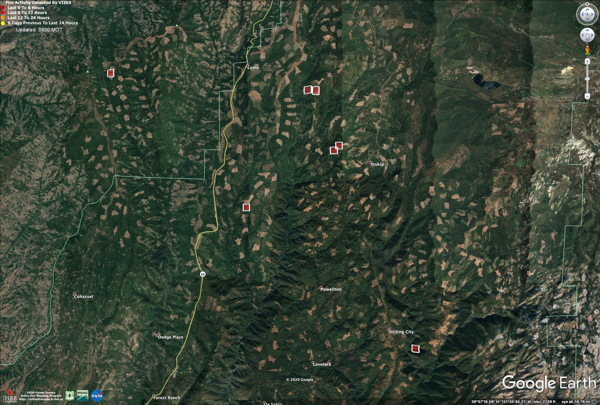
The fires in the lower areas got most of the resources yesterday and seem to be pretty tidied up.
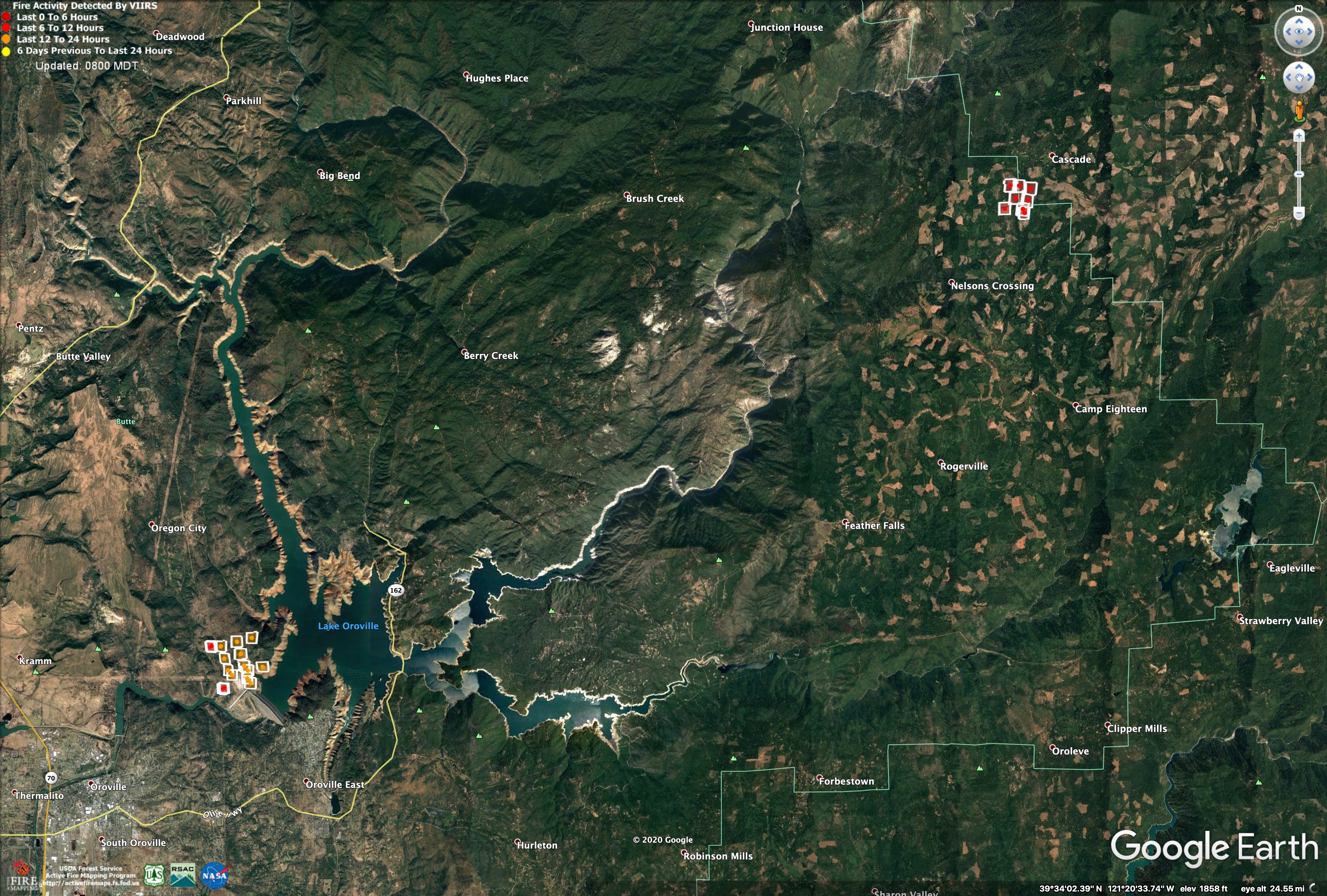
The Potter Fire, at Oroville Dam, is showing a little heat, none of the other grassland/oak fires show up on VIIRs. There is a fire showing on private timberland near Cascade, right inside the Plumas/Butte County Line that I didn’t hear anything about yesterday.
3 Likes
CAL FIRE IMT 4 activated for the BTU Lightning Complex
3 Likes
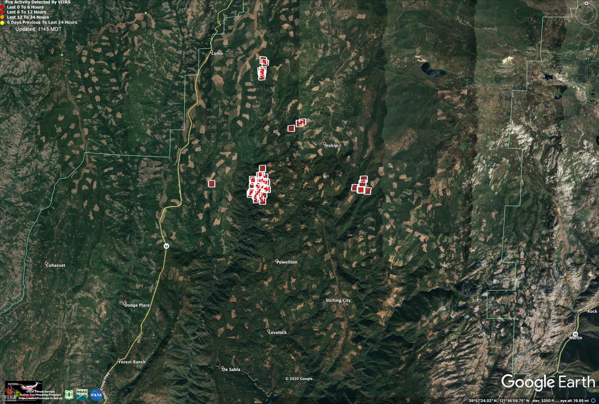
VIIRs is showing continued slow growth on the remaining Butte Lightning Fires. I have been checking them out daily from up by Platt Mtn, and while they have put out a steady amount of light smoke, I haven’t seen any dark smoke or column development since they started.
Yesterday afternoon about 1830 it was 65 degrees, dark and still up by Butte Meadows.
VIIRS data from about 3am, 8/20/2020
Do you happen to know if the fire managed to stay out of Cascade directly ? My friend has a cabin up there
I haven’t heard anything about it. The heat satellites aren’t showing any spread into Cascade, I heard on the radio CAL FIRE doesn’t expect much more growth on the fires in the Complex.
2 Likes
Things look like they are cooking right along right now on the 1-12 (or 1-8, can’t tell).
http://www.alertwildfire.org/shastamodoc/index.html?camera=Axis-Cohasset2&v=81e002f
I took the boys up to Platt Mtn to look at the fires in Upper Butte Creek this afternoon and they seemed pretty subdued, as they have been all week. Fairly light smoke, no real column development. They got airtankers in on the east side of 1-12 today, I believe. S2s were running laps at around 1600, and they had some rotor wing up, too.
2 Likes
Just caught scratchy air traffic of Tanker 911 wanting to jettison their load over the Butte Complex. Anyone know what’s up with that? Can they not land with a full load?
This info isn’t specific to 911, but it’s indicative of DC-10s generally:
Max Take Off Weight:
251,744 Kg
554,995 lbs
Max Landing Weight:
182,798 Kg
402,996 lbs
They can’t necessarily land with everything they took off with, at least with a serviceable aircraft afterwards (assuming a full load)
4 Likes
From Butte County Fire Accidents and Crimes Facebook Page:
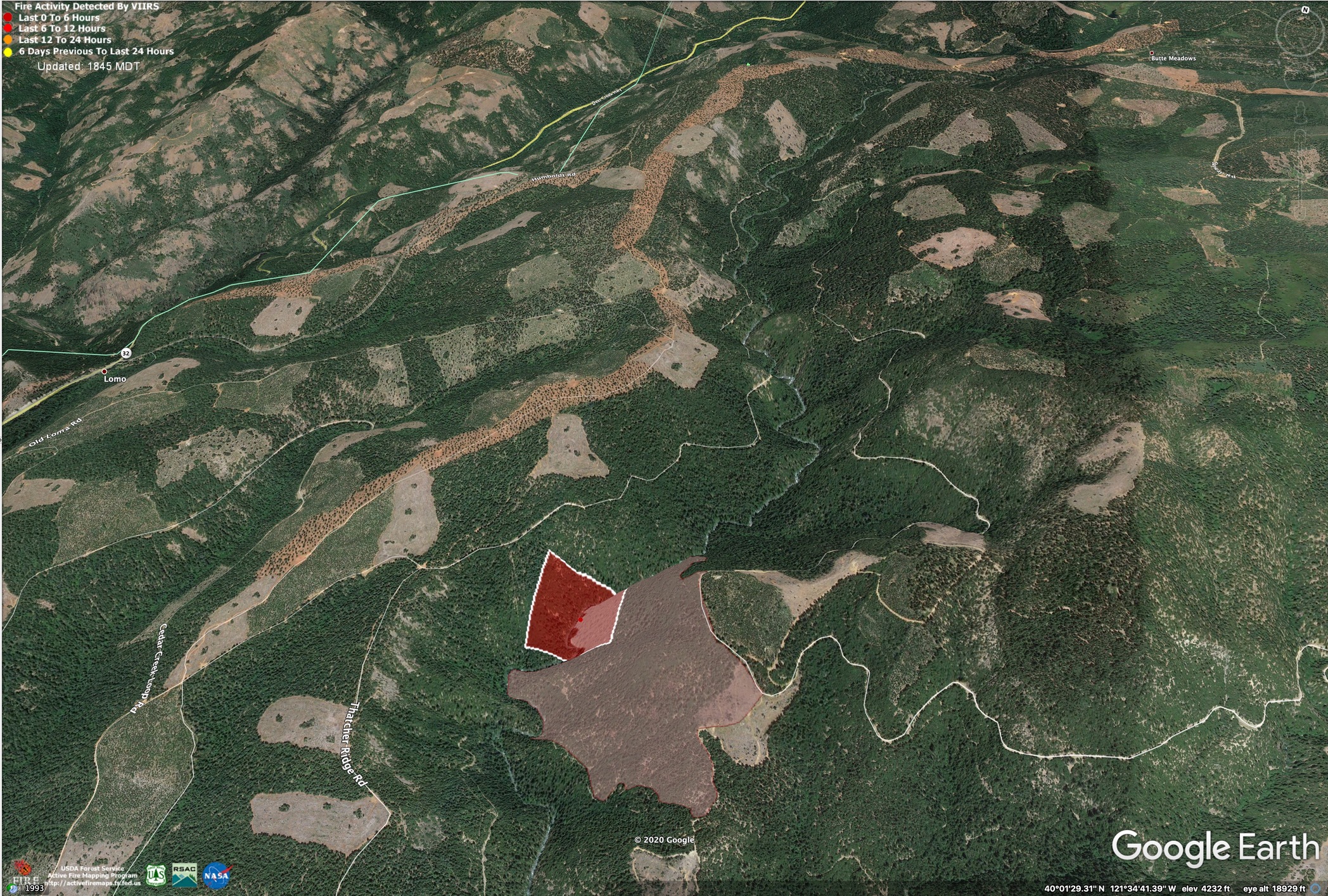
What’s notable is that the reported fire activity is on the North side of the creek. The 1-7 (in pink) has stayed on the south side until now. Very steep, shaly (sp?) terrain around there.
 8/27/2020 @ 2:40 PM: Air support has been ordered for a new fire reported as 2-acres in the area of some previously burning fires in the are between Inskip and Butte Meadows. This fire wasn’t called into Cal Fire dispatch by a citizen but by Cal Fire on scene requesting the aircraft. It’s reported to be in the area of the 1-7 fire.
Update: 3:40 PM: Per Air Attack the fire is on the north side of Butte Creek:
Fire is about 10 acres
Have retardant across the head
Fire is not in the tree tops, is laying down on the ground
Working on the flank
I got up into the BTU fires in Upper Butte Creek yesterday as part of some planning work we are doing for the larger Lassen Foothills region. For the most part, the fires I looked at (1-12, 1-8, 1-7) had very beneficial fire effects, with mainly surface fire and very little mortality of the larger trees. Will post photos later.
3 Likes
Always thanks for your info, updates and insights.
a lot of devastation is happening but there will be some long overdue good burning. always tough with interface…
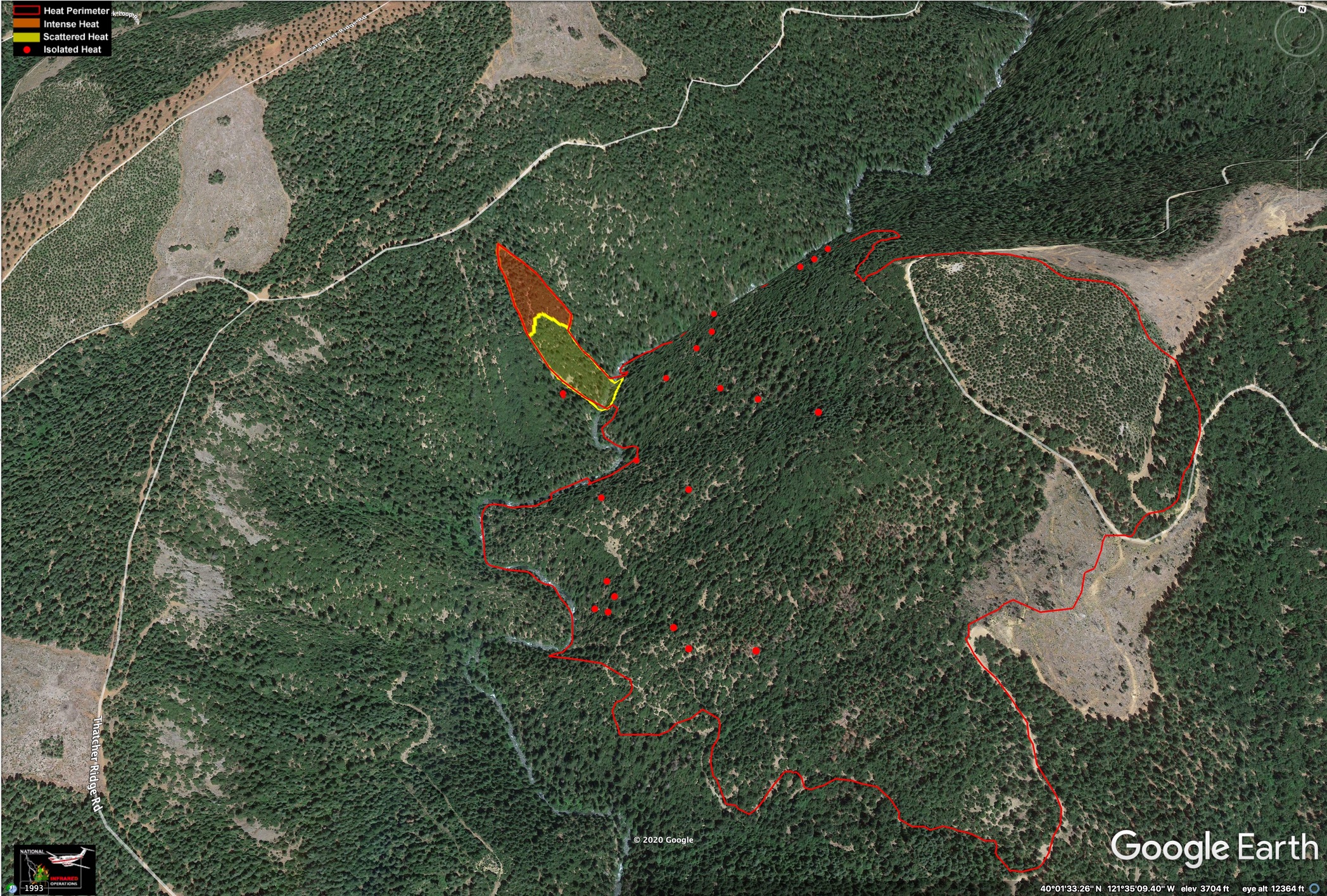
Last night’s IR. 8/27/2020, 2030hrs.
1-12 Fire, looking ENE, toward Inskip. This is about 5 miles NW of Forest Ranch, above the Head Dam on Upper Butte Creek.
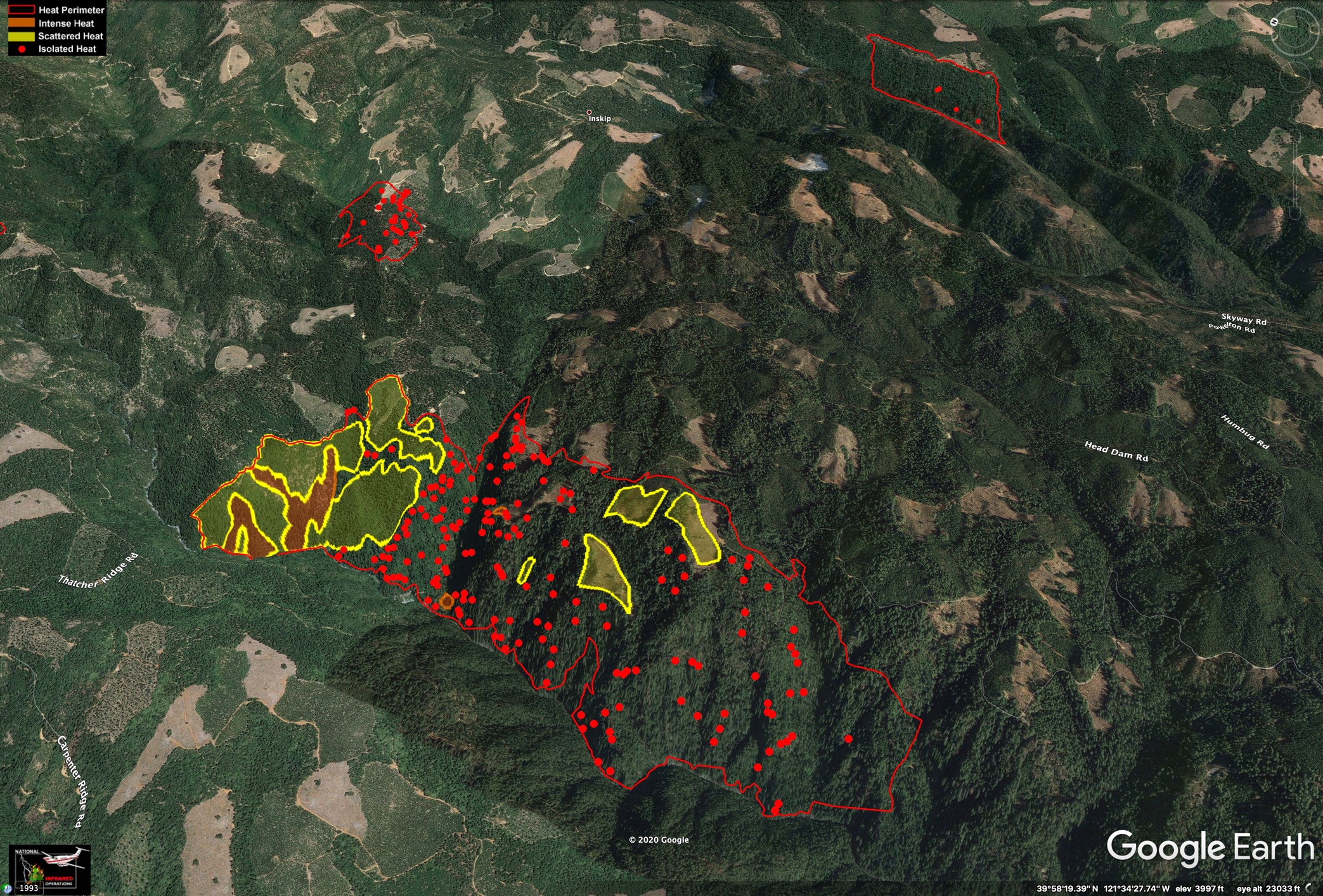
1-7 Fire, looking North.
5 Likes
Good stuff Zeke, thanks!
2 Likes