CalFire afternoon update:


CalFire afternoon update:
Cal Fire is stating the spot fires along Hwy 32 in the Butte Meadows area are now over 100 acres and entering very challenging terrain with a lot of fuel.
368,256 acre and 12% contained.
7/31 AM Update:
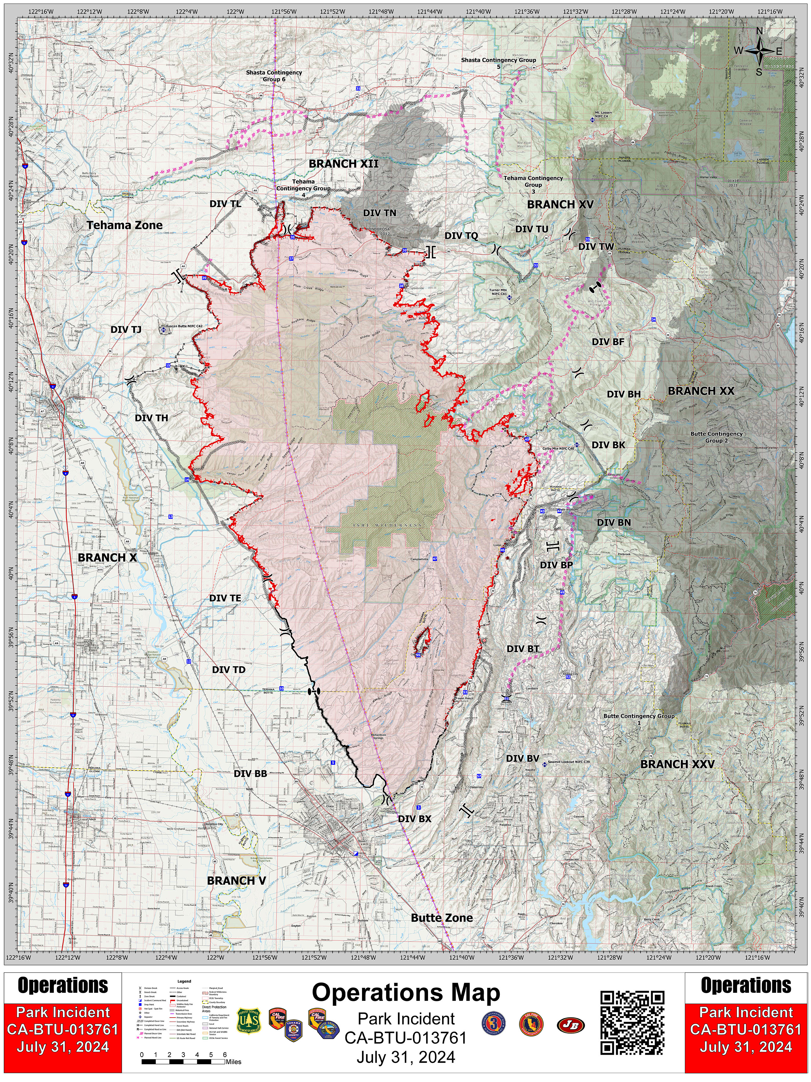
389,791 Acres @ 18% Containment
Single Residences Destroyed: 209
5,849 Personnel Assigned
Critical Resource Needs:
10 - Type 1 Engine Strike Teams
7 - Type 3 Engine Strike Teams
27 - Type 6 Engine Strike Teams
22 - Crew Strike Teams
8 - Type 2 Crews
13 - Water tenders
11 - Masticators
12 - DIVS
26 - HEQBs
8 - FALM
Numerous overhead
Damage Assessment Information:
Butte Co- inspections 65% complete
Single Family Residences- 154 Destroyed, 13 Damaged,
Commercial- 4 Destroyed,
Other Minor- 98 Destroyed, 18 Damaged,
Infrastructure- 2 Destroyed, 1 Damaged.
Tehama Co- inspections 85% complete
Single Family Residences- 55 Destroyed, 0 Damaged,
Commercial- 2 Destroyed, 0 Damaged,
Other Minor- 45 Destroyed, 3 Damaged,
Infrastructure - 1 Destroyed, 1 Damaged.
Number of people in evacuation orders and warnings:
Butte County- 7,800 residents impacted, 49 in temporary shelters.
Tehama County- 1250 residents impacted, 13 in temporary shelters.
Shasta County: 8,310 residents impacted, 32 in temporary shelters.
Plumas County: 87 residents impacted.
Lassen Volcanic National Park: 50 residents impacted.
Anticipated Incident Containment Date: 08/15/2024
OPS Map:
389,791 acres @ 18% containment with a lot of unfilled resource requests still standing.
At this point I’m doubtful the outstanding requests will be filled, or they will be filled very slowly. There’s a ton of draw down throughout the state already. It’ll take one more big one to wreak havoc.
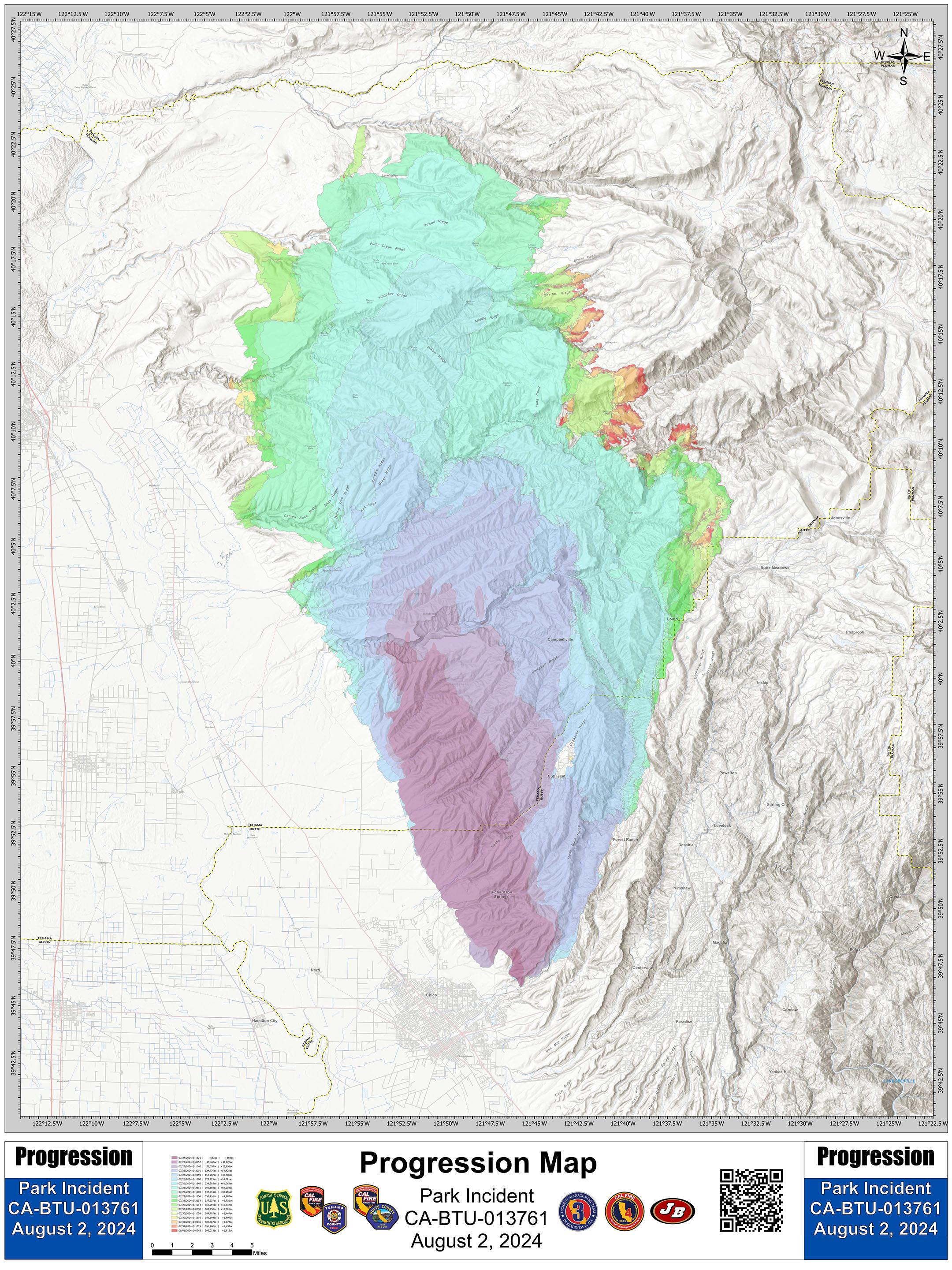
Aug 2, 6:05 AM
The fire is now 397,629 acres & 24% contained per CAL FIRE.
400,956 acres & 27% containment as of 0725 8/3/24
Tanker LAT 03 was dispatched out of Fresno to the incident today… must have had some open fire to quell. Sure there was several LATs. Didn’t check flight trackers at the time.
Currently the copters are working in Branch XX.
Aug 4, 10:54 AM
Per CAL FIRE -
The fire is 401,301 acres and 30% Contained
The spread of the Park Fire overnight was minimal. Residual rainfall moisture on the eastern portion of the fire kept flames from spreading through the fine dead fuels. However, fire did continue to burn in the larger dead and downed fuels.
It’s expected to reach the lower 100s today across the region, with relative humidity dipping to the lower to mid-teens.
Today’s hotter temperatures, drier conditions, and higher wind speeds will contribute to increased fire activity. Fuels that received moisture over the last few days will dry out again.
Spot fires and fire activity is expected to continue to challenge firefighters. Critically low fuel moistures, steep canyons, long drive times, and daily spot fires have caused difficulty in suppressing the fires.
Firefighters continue to offensively engage in constructing new fire line, reinforcing line and mopping-up when possible.
Lassen National Forest: The northeast corner of the fire continues to be the major focus for crews. The fire is well established in the Mill Creek drainage and firefighters have been taking advantage of favorable weather the past few days to go as direct as possible on the fire’s edge west of Tuner Mountain. 95,691 acres of the fire are burning on the Lassen National Forest.
In addition to direct attack, Tamarack Road is being prepped for holding as crews work to build line above Mill Creek on both sides of the canyon. Because of the incredibly steep and rocky slopes along the creek drainage, crews are scouting for areas where they can more actively attack the fire.
There are more than 1,000 firefighters on this corner of the Park Fire including 5 Interagency Hotshot Crews assigned to keeping the fire away from the communities of Mineral and Mill Creek.
Just for clarification, that was yesterday’s IAP, just in case anyone is trying to locate a resource or frequency.
Frequencies have not changed and that’s what I had available.
Easily able to navigate to today’s IAP from there.
The morning brief stated there are some changes, mostly with air tactics as I understand but it would be wise to double check and make sure you are up to date.
New clone today, V5.
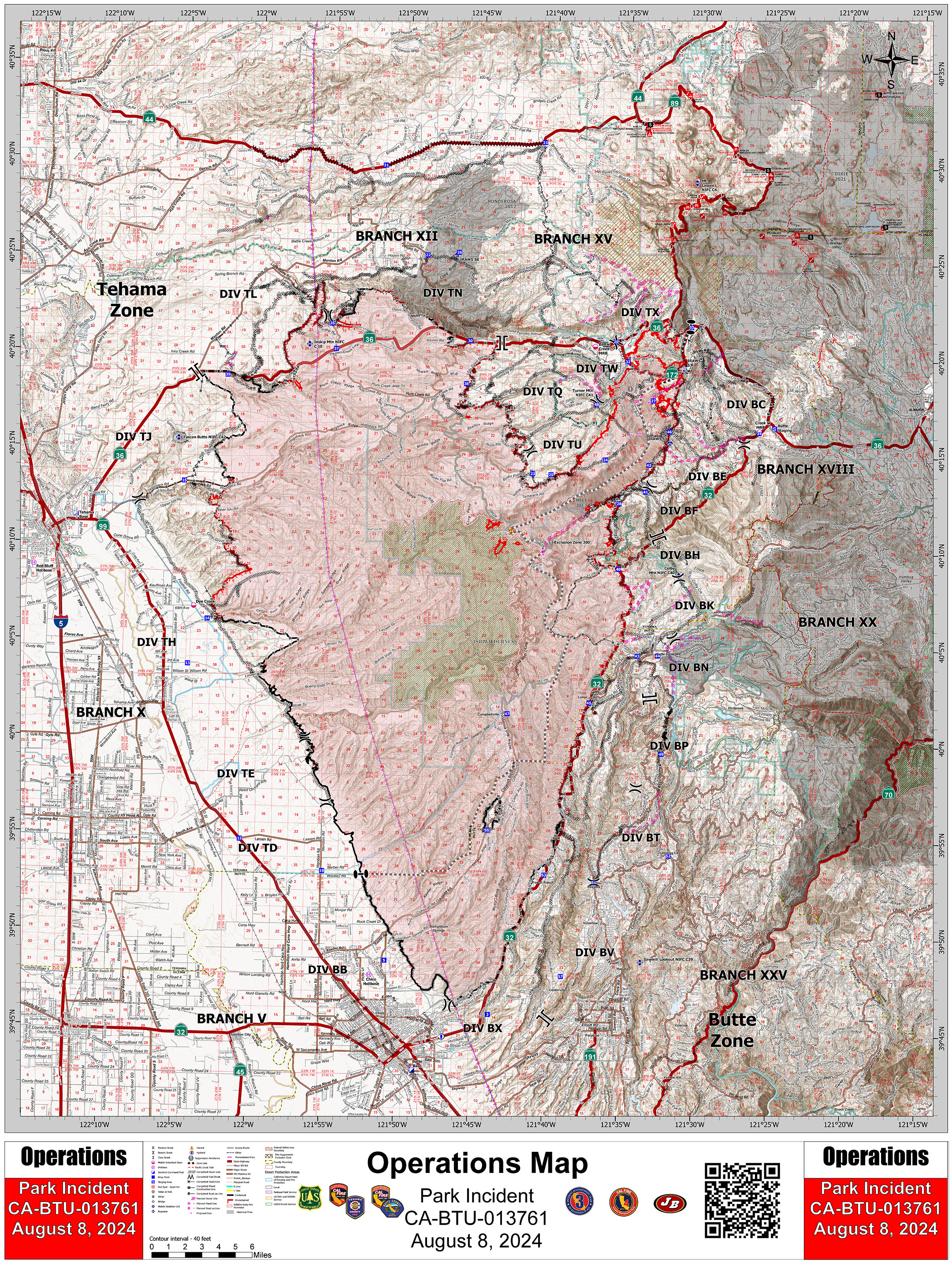
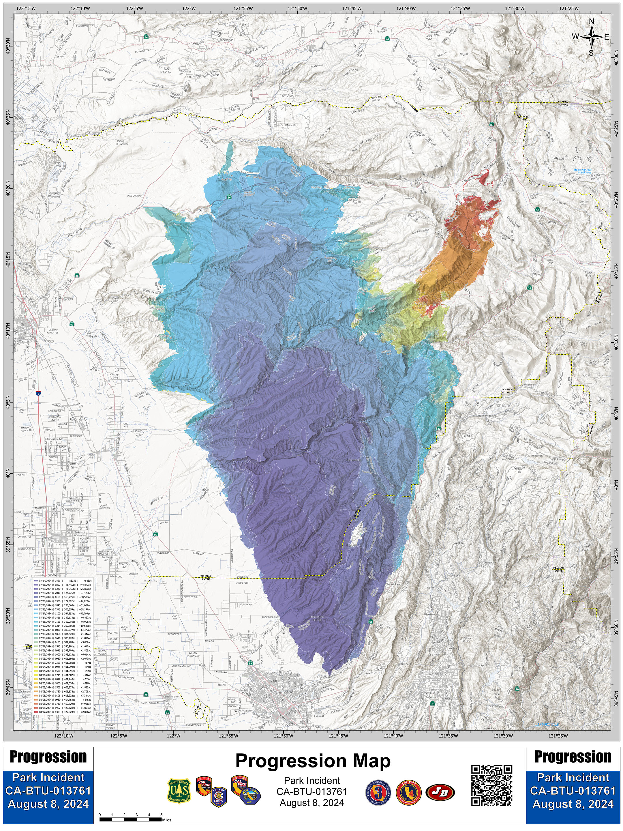
401,740 Acres @ 34% Containment
Anticipated Incident Containment: 08/31/2024
Damage Info:
Butte Co- inspections complete
Single Family Residences- 253 Destroyed, 19 Damaged,
Commercial- 5 Destroyed,
Other Minor- 168 Destroyed, 26 Damaged,
Infrastructure- 2 Destroyed, 2 Damaged.
Tehama Co- inspections complete
Single Family Residences- 128 Destroyed, 0 Damaged,
Commercial- 2 Destroyed, 0 Damaged,
Other Minor- 80 Destroyed, 4 Damaged
Infrastructure - 1 Destroyed, 1 Damaged.