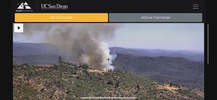
I’m not sure if this BTU or what. Anybody know anything about this new start near Palermo?
Turkey Fire 7-10 acres
8 to 10 acres light flashies MROS short range spotting
Seem to remember watching the foreground hill as seen from Rattlesnake Peak camera burning in past 3 years or so. Swedes Flat has become quite the ‘wildfire alley’ in the past decade. PG&E wx stations showing sustained SW winds 5-7, gusts to 15mph.
15-20 acres. Requested 5 additional engines
This exact area was the stomping ground of major wildfires in 2013 and 2017 and then the footprint of a smaller dud in 2019 when the vegetation simply wasn’t thick enough to facilitate aggressive fire activity.
I’m talking about the 2,264 acre Swedes Fire of August 2013; the incredibly impressive 6,033 acre Chinese Wall Road Fire of early July 2017 which marched right through the young brush of the Swedes Fire scar like it was no problem at all --and last and certainly least the Swedes Fire of September 2019 which burned 496 acres. The third fire being so unremarkable that almost no one remembers that one even happened. I imagine this new fire could face that same outcome. Call me optimistic.**
Retardant around the fire. 15-20 acres with some potential for spotting or small runs. Now slow rate of spread.
Halfway between Chico and Grass Valley AABs, and 50 miles straight out from McClellan, it’s amazing any of these poor little fires ever got a chance to grow up to be anything!
Don’t get me wrong, I know how volatile this area is. This is only a stones throw south from the footprints of the worst wildfires in recent California history (Camp 2018, Bear 2020 & Dixie 2021). I’m just saying this particular ridgeline the fire’s currently on has been burned over so badly 3 separate times that it’d be quite surprising to me if this new fire somehow became anything of note. Unless it moves further east into unburned land.
Pot growing changed the picture pretty heavily in South Butte County in the late 2000s. previous to that, there wasn’t much of value out here to worry about. The 2013 Swedes Fire burned a bunch of growers shacks and other stuff that got hauled in here during the Prop 215 bonanza, and it was such a cluster we had to have a Type I team for a 2,200 acre grass and brush fire.
Who is “we”??
The citizens/taxpayers of Butte County. I was on the fire as a contractor, so I guess it includes me, too.
I guess I do not get your reply. Mine was simply… I did not see you in the room when the decision was made based on conditions on the ground, in the region and the state to order a team.
I think he is saying that because of the complexity added by the shacks and such, a team was necessary in ground where it would not have been ordinarily.
The ego…don’t misspeak in this forum.
Curious if you feel like cannabis farming added complexity to the incident which made the team order necessary in a place we might not have needed one before the Green Rush?
A change in direction a little here. Just curious about the fire name. Is that Turkey Mtn, Turkey Ridge, land of the Turkey Vulture or just great turkey hunting?
Not sure I am following your comment.I was simply stating a fact that I did not see Zeke in the room when the decision was made to order a team… because I was in the room.
The decision to order a team on any incident has more to do with the ability to logistically support the incident. It can have to do with the status in the region and availability of qualified people to fill critical roles. It can have a lot to do with potential… and sometimes fires take off… exhibit extreme behavior and then give up.
There is far more dope there now than before the Swedes. One of the verified effects in the post fire environment is a drop in land value so the growers move in. That is very present in the Camp, Bear, Wall and Swedes scars. I flew over that area for 1/2 hour yesterday, there are maybe 4 large grows within 2 miles of todays fire.

