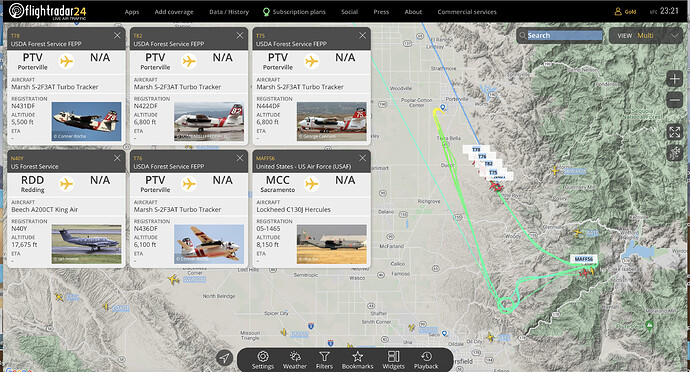
MAFFS 2 and 4, T-75,76,78,82 all inbound. Looks like they are strengthening the southern lines pretty good. Correction, MAFFS 6 not T-914. Miss heard the scanner
Kinda neat seeing them all lined up like that. 2 and 4 dropped and went to SMX but it looks like 6 is making their way back to MCC.
I think there was an ANG c130 also.
Thanks for the update
AA has traded off relief twice and have had fixed wing going on… three type 3 tankers that I could hear on tactics. Round robin a few hours this morning. Can’t hear what division they are working.
25,643 acres and 40% contained this morning. Minimal activity on east side allowed reoccupation of Pala Ranches. Inciweb updates states lines in place are holding but forecast winds are a concern. Minimal smoke on Alert cams.
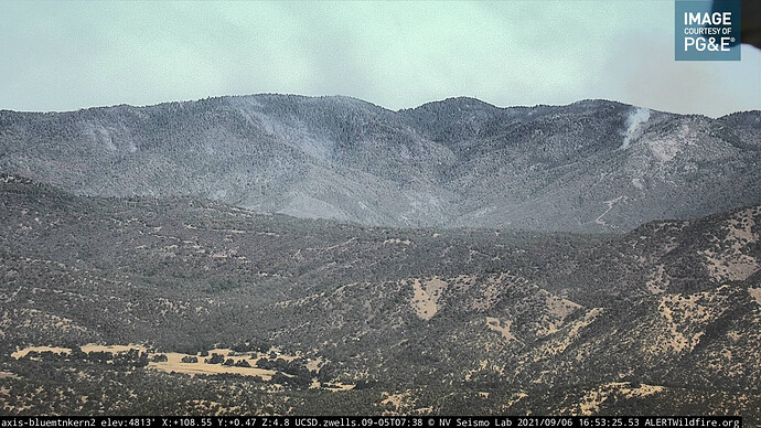
Blue Mtn cam has a building fire start or an island burning out:
http://www.alertwildfire.org/sierra/index.html?camera=Axis-BlueMtnKern2&v=81e003f
About 1300 I heard a helitanker dispatched and now they are returning Porterville at 1415. Smoke is hanging in there but, no longer building.
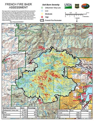
Checking the 9/03 planning map, there is unburned fuels between dozer line and the fire edge in Div, A,E & Z. They all face the blue cam. Plenty of potential for flair ups that are within the dozer lines. Too large to upload.
Kern County sent a task force today to this fire as mutual aid @ 1339
Here AA swap out relief this morning. Haven’t heard any fixed wing on the AA frequency. Most likely a helco show I can’t hear being too low level.
Blue mtn cam shows smoke from line.
http://www.alertwildfire.org/sierra/index.html?camera=Axis-BlueMtnKern2&v=81e003f
This morning IR map shows intense heat due west of Alta Sierra along the Cedar Creek drainage.
https://caltopo.com/map.html#ll=35.72508,-118.60199&z=14&b=t&o=f16a%2Cr&n=1,0.25&a=mba%2Cfire%2Cmodis_mp
Was checking the MODIS VIIRS detections on RAMMB and its not showing any longer. Today AA went up for about an hour this morning then promptly returned to base.
It’s looking very good heat detection wise:
CalTopo - Backcountry Mapping Evolved
Inciweb 26,702 acres at 62% contained.
This mornings FB briefing stating most hose is being backhauled indicating significant progress. Hwy 155 is being opened back up and the IMT is prepping to turn the incident back over to the home unit. Good news.
https://fb.watch/7V_VThz_2J/
Some wild weather came through the region and brought some wet stuff over the fire. Transfer back to local command Sunday morning.
9/25 around 2200; Firewatch 51 came over this burn scar and picked up 3 heat signatures in IR light only. With additional fly time over this area, they did not see visible light and determined they were safely inside the burn. They flew on to Windy fire, the primary mission.
2100 the 29th of Sept. and Firewatch 51 flew an IR mission on this and the Walkers fires.
Just an interesting note that this happened.
I’ll may check the incident folder for a IR product.


