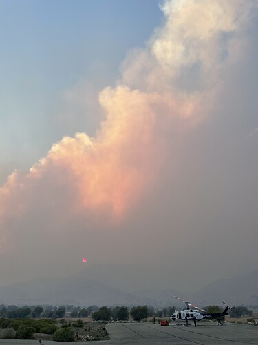
crossed hwy 155above Pala Ranch, burning north towards Kernville, and east towards Wofford hts. . Wofford Hts has been evacuated, Kernville and riverkern under warning, large embers falling.
Caltopo with heat last plotted around 15:00hrs: (focus on hwy155)
https://caltopo.com/map.html#ll=35.73032,-118.54416&z=14&b=t&o=f16a%2Cr&n=1,0.25&a=mba%2Cfire%2Cmodis_mp
H-531, H-407, H-408 all working tonight, so far so good on visibility
Does anyone know if Alta Sierra burned?
Multiple structures were impacted near Alta Sierra last night. At least 1 was fully involved per radio traffic. Unsure of the extent, most traffic tonight has been concerning keeping things out of Wofford Heights.
Alta Sierra Friends (Kern County, CA) Keeping Each Other Informed
Chris Ritchie · 4m ·
Cory just arrived up there and appears all the houses are there…
above is latest from Alta Sierra.
Does the MODIS display more accurately over time on Caltopo? There is a persistent red dot just about where my cabin is. I know there is a large margin of error but that pesky dot has been there for several days. Thanks!
AA has been up for a couple of hours and I probably missed some traffic, howevevr, AA is coordinating with Helco about retardant building along hwy155 with the copters.
I don’t hear any fixed wing traffic up to 11:20.
DesertSledder:
RE the Caltopo plotting of heat is rather detailed here by NASA:
(I can’t answer your question but it’s a lot to digest and I am sure you’ll find it here)
Anybody have any idea about the fire effects of this. Is it all scorched earth or did it burn with a nice low intensity?
Less vegetation covering and shading the earths surface from direct solar warming of the soils is not good. Warming soils change the vegetation models. I see that the evergreen needle pines are receding from the warmer lower elevations they used to inhabit and flourish in.
But, perhaps start a post like this that takes shape aside from the Fire info.
Barely much smoke showing on satellite and no heat at all on the French and Walkers. Intel seems to exemplify contained fire spread. This is sunrise capture so not much light. Refresh later after suns been up for many hours.
Inciweb 25,895 acres and 43% contained.
May be a slop over on the west side of the fire, lot of heat on satellite.
http://www.alertwildfire.org/sierra/index.html?camera=Axis-BlueMtnKern2&v=fd40731
I believe there was a burn show on the west side today
Burn show?
Firing Op, very often referred to as a burn show
This morning quick brief.
The fire operations from yesterday were successful. These daily videos have been short, straight to the point, and very informative.
IC was turned over back to CND local agency BC41.
Sounds like the team is off of this…haven’t tracked which fire they were reassigned to.
Inciweb 26,535 and 98% contained. 2% just incase it starts up and maybe funding.
