Looking out to next week, the GFS has been consistent in showing a strong ridge of HP developing in the wake of a small system passing through far Northern California/Southern Oregon( Jefferson). The HP ridge looks to dominate the weather between Tuesday-Saturday of next week. If the model is correct , there could be an extended period of offshore flow, with some strong winds around the 30/31 time frame. I would expect that this could become a “high risk” event for PDS.
Would be interested to see what some of the weather folks think.
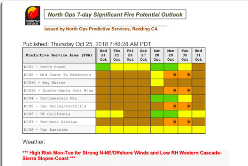
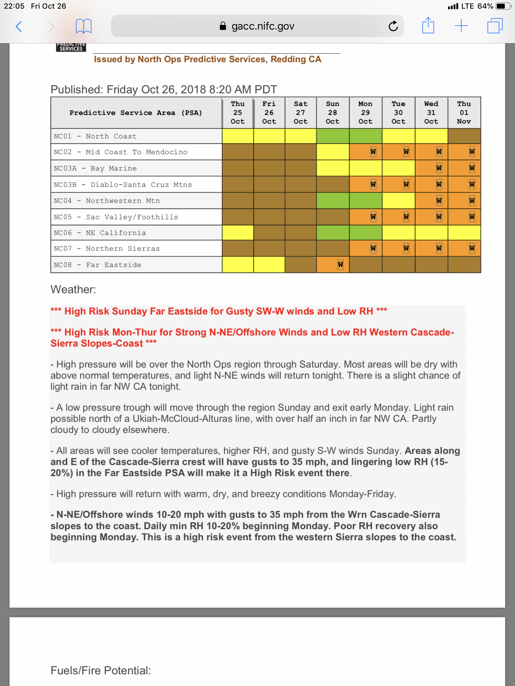
Some high risk days have been added for NOP’s.
2 Likes
Should be an interesting week for most of the state. Long lived offshore wind event, with a possible re-load next weekend.
Weak to moderate SA event taking shape for much of Socal, and warm temps. Main issue looks to be a long termed event.
For North Ops, another long termed event, with some moderate winds and potentially stronger gusts at night.
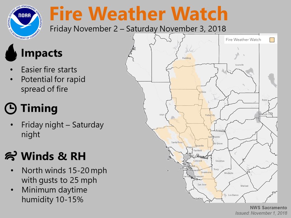
Fire Weather Watch
URGENT - FIRE WEATHER MESSAGE
National Weather Service Sacramento CA
318 AM PDT Mon Oct 29 2018
…Critical Fire Weather Conditions Tonight through Tuesday Night for Portions of Interior Northern California…
High pressure building into the region will create increasing north winds starting tonight and continuing into Tuesday night for portions of interior northern California. These winds will significantly lower humidity and fuel moistures leading to critical fire weather conditions tonight into Tuesday night.
CAZ215>219-263-264-279-292300-/O.NEW.KSTO.FW.A.0010.181030T0600Z-181031T1300Z/
Northern Sacramento Valley to Southern Tehama County Line Below 1000 Ft-
Central Sacramento Valley in Glenn, Colusa, Yuba, Northern Sutter, and Butte County Below 1000 Ft-
Southern Sacramento Valley in Yolo-Sacramento Far Western Placer, southern Sutter and Solano County
Below 1000 Ft-Carquinez Strait and Delta-Northern San Joaquin Valley in San Joaquin and Stanislaus
Counties Below 1000 ft-Southeast Edge Shasta-
Trinity NF and Western Portions of Tehama-Glenn Unit-Lake County Portion of Lake-Napa-Sonoma Unit-Eastern Mendocino NF-
318 AM PDT Mon Oct 29 2018
…FIRE WEATHER WATCH IN EFFECT FROM THIS EVENING THROUGH LATE TUESDAY NIGHT FOR GUSTY NORTH WINDS AND LOW HUMIDITY FOR FIRE WEATHER ZONES 215, 216, 217, 218, 219, 263, 264, AND 279…
The National Weather Service in Sacramento has issued a Fire Weather Watch, which is in effect from this evening through late Tuesday night.
-
AFFECTED AREA…Fire weather zone 215.Fire weather zone 216.Fire weather zone 217.Fire weather zone 218.Fire weather zone 219.Fire weather zone 263.Fire weather zone 264.Fire weather zone 279.
-
WIND…North winds 15 to 25 mph with gusts to 35 mph on the west side of the Sacramento Valley and exposed ridges.
-
HUMIDITY…Minimum humidity as low as 11 to 17 percent Tuesday with areas of poor humidity recovery 28 to 36 percent overnight Tuesday.
-
IMPACTS…any fires that develop will likely spread rapidly. Outdoor burning is not recommended.
PRECAUTIONARY/PREPAREDNESS ACTIONS…
https://forecast.weather.gov/MapClick.php?lat=38.49594490000004&lon=-121.47800699999999#.Wzeqm9JKi70
2 Likes
No Ops starting to preposition. HUU sending a ST to SCU.
2 Likes

Never Happened
Are you from the future?
2 Likes
So much for that watch…
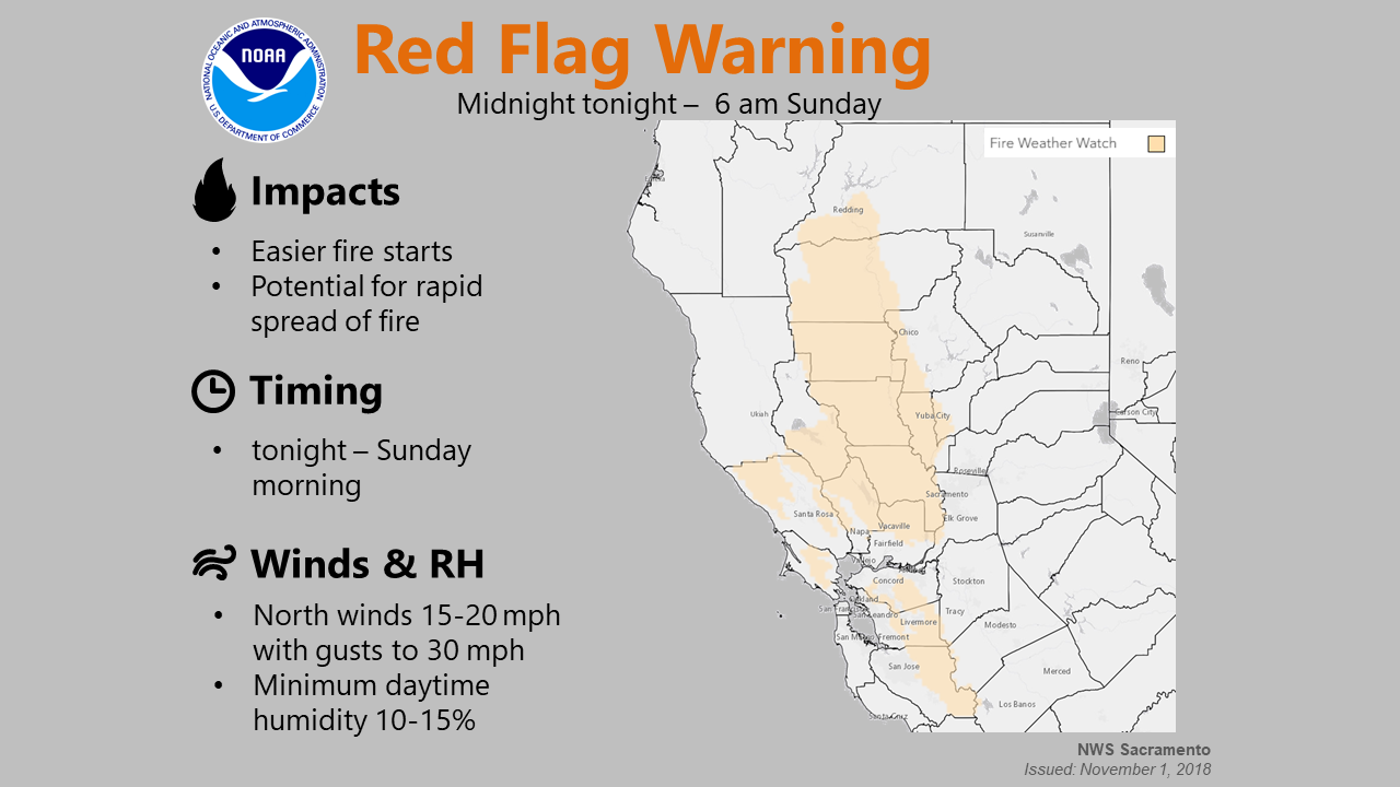
URGENT - FIRE WEATHER MESSAGE
National Weather Service Sacramento CA
330 AM PDT Fri Nov 2 2018
CAZ215>218-263-264-279-022300-
/O.UPG.KSTO.FW.A.0011.181103T0600Z-181104T0100Z/
/O.NEW.KSTO.FW.W.0012.181103T0700Z-181104T1400Z/
Northern Sacramento Valley to Southern Tehama County Line Below 1000 Ft-
Central Sacramento Valley in Glenn, Colusa, Yuba, Northern Sutter, and Butte County Below 1000 Ft-
Southern Sacramento Valley in Yolo-Sacramento Far Western Placer, southern Sutter and Solano County Below 1000 Ft-
Carquinez Strait and Delta-Southeast Edge Shasta-Trinity NF and Western Portions of Tehama-Glenn Unit-Lake County Portion of Lake-Napa-Sonoma Unit-Eastern Mendocino NF-
330 AM PDT Fri Nov 2 2018
…RED FLAG WARNING IN EFFECT FROM MIDNIGHT PDT TONIGHT TO 6 AM PST SUNDAY FOR GUSTY WINDS AND LOW HUMIDITY…
The National Weather Service in Sacramento has issued a Red Flag Warning, which is in effect from midnight PDT tonight to 6 AM PST
Sunday. The Fire Weather Watch is no longer in effect.
-
AFFECTED AREA…Coast Range, east slope Coast Range foothills and western Sacramento Valley.
-
WIND…North to northeast winds 15 to 25 with gusts to 35 mph.
-
HUMIDITY…Poor overnight recovery of 30 to 45 percent tonight and 20 to 35 percent on Saturday night. Minimum humidities 7 to 17 percent on Saturday.
-
IMPACTS…Any fires that develop will likely spread rapidly. Outdoor burning is not recommended.
PRECAUTIONARY/PREPAREDNESS ACTIONS…
A Red Flag Warning means that critical fire weather conditions are either occurring now, or will shortly. A combination of strong winds, low relative humidity, and warm temperatures can
contribute to extreme fire behavior.
3 Likes

https://www.wrh.noaa.gov/lox/fire_weather/fm_new.php?wfo=MTR
Many locations meeting red flag criteria or close to it.
1 Like