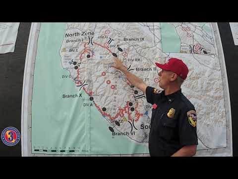
71,000 acres
8% contained
24,000+ structures threatened
129 structures lost still counting
How are things behaving after the marine layer burns off? It looks like it has been laying down quite a bit the last few nights.
Lots of good info at both the 7am Ops brief and the 6am Press brief. Both were streamed live and are available online if you’d like to go back and hear the full fire assessment, comments from LE and weather/fire behavior predictions.
The You Tube link is for the short summary version from Ops Chief Mark Brunton
Does anyone know if there is a wetting rain falling over the active fire area? Or if there’s been dry lightning?
A little rain but lightning yet.
Confirmed Fatality from the Sheriff’s Office. Person was located at the end of Last Chance road. Information was confirmed during the evening press conference.
always bad news. prayers to family and friends.
That looks like hard place to get out of and would take a lot of time even in good circumstances. Prayers to their family and friends.
Extremely difficult been on a few calls back in there back in the day. Over an hour to get there from the highway.
@TheBrushSlasher the most intensity we have seen has been in the evening. The last two nights saw very active torching and running towards houses. Also we saw about two minutes of rain and that’s it. Nothing to really affect the incident.
78,000 acres
13% containment
Looking to see if there is a list of addresses damaged. Trying to find info on a specific address in Davenport
No. The only information they have released so far is a number, 330 structures destroyed (the includes both homes, sheds, garages etc…)
That breaks down to 11 in San Mateo County, 319 in Santa Cruz County. They have not yet been able to access the most fire affected areas due to trees down, roads blocked, bridges out. They continue to do Damage Assessment today.
Overall, the situation reported in the Davenport area has been that good progress is being made in defending that area.
Thanks for the info. I figured as such. Just been gone on the SCU complex and seeing if there was a update.
They have a good website set up for resources for evacuees, check back for future information.
https://www.santacruzcounty.us/fireresources.aspx
They are beginning to populate the Damage Assessment map with data. It might be slow to load, be patient.
https://sccgis.maps.arcgis.com/apps/webappviewer/index.html?id=5461c7f372e24ab68ca386e73d58e35a
80,137 Acres
19% Containment
538 Structures Destroyed
1,697 Personnel Assigned
81,333 Acres
21% Containment
646 Structures Destroyed
1,982 Personnel
82,540 Acres
26% Containment
799 Structures Destroyed
554 of the structures are single family residence
2,019 Personnel Assigned

