Evacuation WARNING went out for east of Volcanoville
Wallace Peak is a newer PGE weather site. It is on the north side of the Rubicon drainage, almost due west of the Fork Fire. Within just a few miles, so should be representative of the fire ground conditions.
Location: Wallace Peak
Current Temperature: 66°F
Relative Humidity: 18%
Wind Gust: 41 MPH
Observation Timestamp: 18:50
5 Likes
I worked all day today at the Foresthill Fire DOC. Wind remained constant all day and this fire defied all expectations for growth. Last update at 1800 was that the fire remains south of the Rubicon and all in El Dorado County. The King Fire burn scar wraps the west, north and part of the south aspects of this fire. Fortunately it did not catch the 40 plus mph wind gusts crossing the area the entire day. Crews are working both direct and indirect with limited resources and will have winds from the East until mid afternoon Wednesday. Hoping it continues to lay low through the night. As for size, no aircraft on the fire for most of the day. No air assessment of size after about 1500 hours so it is a rough estimate of 500 acres at 1800 hours.
14 Likes
5 posts were merged into an existing topic: CA-ENF-Fork???
Crews are actively engaging the fire with hose lays and hand lines but the 5 guys on the fire (sarcastic) are challenged by terrain and the size of the fire. Sounds like they are going direct overnight but much work and a little luck is needed to keep this from becoming a big problem tomorrow. The King Fire burn scar is definitely assisting in slowing the spread of the fire but as the low pressure system slides south the winds are going to push this to the northeast through tomorrow putting the focus on the Rubicon drainage which is steep and has very limited access.
7 Likes
Some more details from Inciweb: The Fork Fire is burning 15 miles NE of Pollock Pines, moving west toward the King Fire burn scar in the Rubicon drainage on the Georgetown Ranger District. Currently there are 13 engines and 4 water tenders fighting the fire with additional resources on order. Air resources were also deployed but were hampered by turbulence and smoke. A Type 2 incident management team, Southwest Team 4, is enroute and will arrive Thursday.
1 Like
Then they (the Team) has an in-briefing of the past and current situation, has a chance to gather intell, and then assumes command of the fire. At the earliest, possibly Friday at 1800. More likely Saturday at 0600. The crews on the fire now, will have to hang in there, do what they can do safely, and try to take care of themselves till help/relief crews arrive.
1 Like
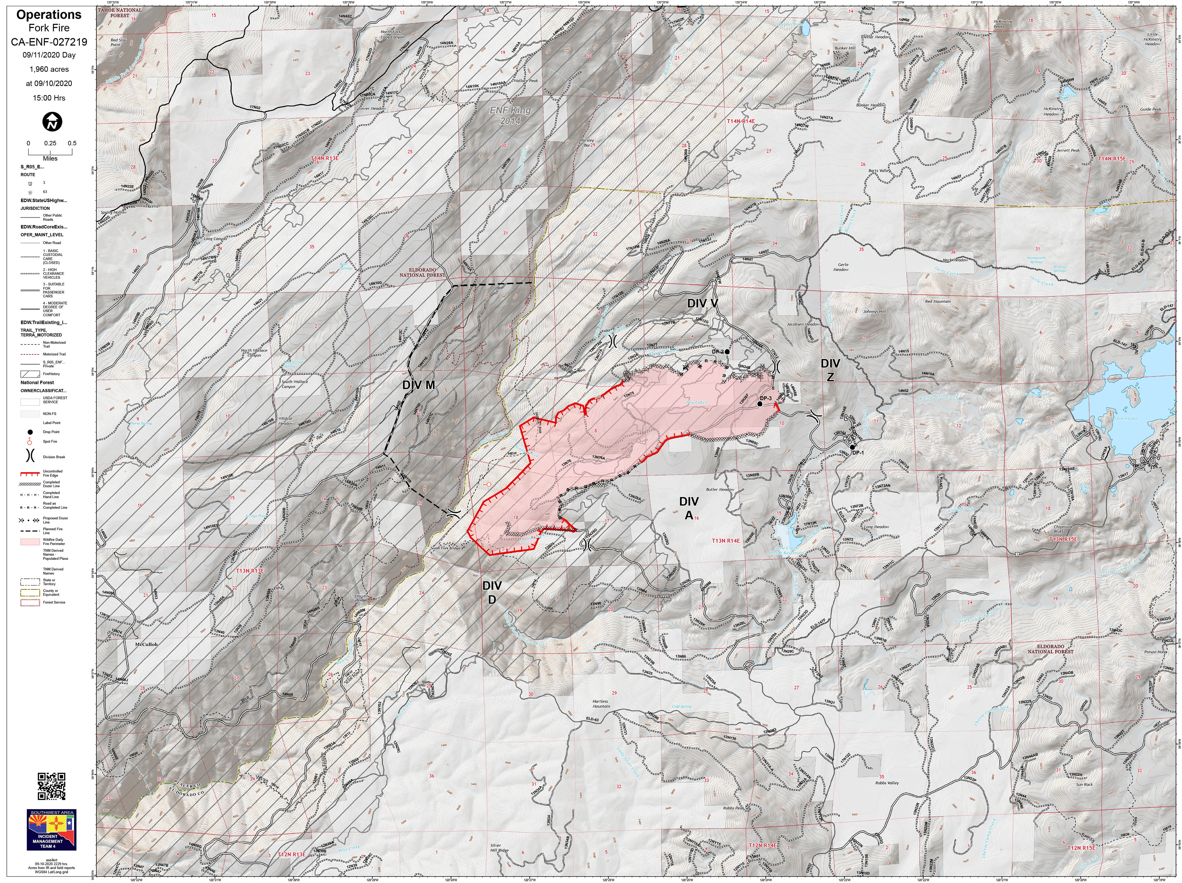
The Fork Fire is currently 2,500 acres,0%contained Acreage is an estimate only. There was active fire behavior on the Fork Fire last night with moderate to rapid rates of spread; the fire has spotted into the Rubicon drainage.
Per ENF Twitter
4 Likes
Drove up wentworth springs rd. this morning. Stopped at volcanoville rd. Sheriff officer said they evacuated 200 homes in volcanoville last night, fire slowed pretty good in old King burn but dropped into Rubicon canyon. There was actually more smoke in Pilot Hill off Hwy 49 than in Georgetown. Humidity felt 30% or better and wind was non existent.
4 Likes
9 posts were merged into an existing topic: CA-ENF-Fork???
As of 730 am 9/11 CA-ENF FORK FIRE: 2,200 acres brush, timber, 7% contained. Active fire behavior overnight with single tree torching and spotting. Structures remain threatened and evacuation orders remain in effect. Multiple recreation sites have been evacuated. Threats to recreation residences, power and water facilities and recreation sites, critical wildlife habitat, and private timberlands. Road, area and trail closures are in effect. SW Type 2, Team 4 in command.
2 Likes
A team was assigned and they arrived either yesterday or this morning, haven’t been paying to close attention to this one.
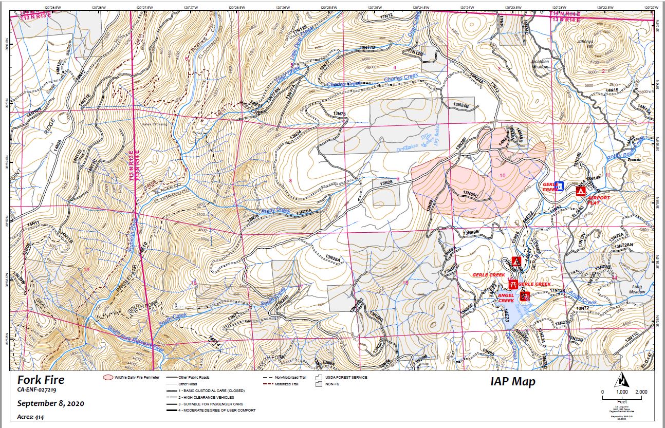
IAP’s are available on the FTP site. Here is the one for today: https://ftp.nifc.gov/public/incident_specific_data/calif_n/!2020_FEDERAL_Incidents/CA-ENF-027219_Fork/IAP/Fork_AIP_20200911.pdf
1 Like
Southwest Area Team 4 took the fire yesterday (9/11) at 7am.
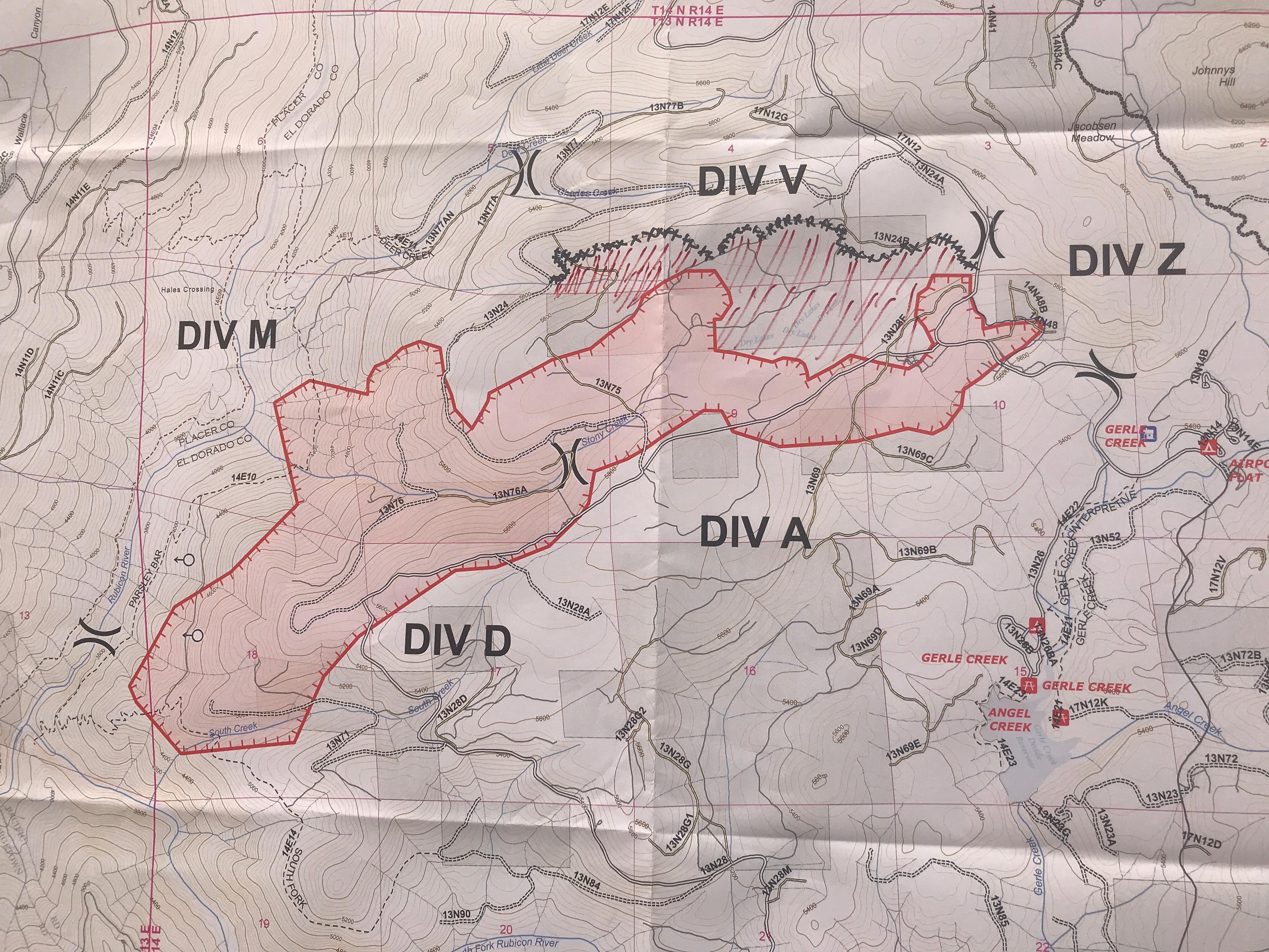
The fire is backing slowly into the Rubicon Drainage under favorable conditions. The fire was mapped by IR flight last night at 1668 acres. Control efforts are hampered by the steep terrain of the Rubicon drainage (2000 feet top to bottom) standing snags and down dead fuel in the King Fire scar.
This fire has a lot of open line on the north side and is capable of coming out of the drainage with intensity. The incident is scouting for control points into and above the drainage.
6 Likes
The IMT is doing two video briefings per day. The morning incident briefing is recorded and the 1800 hour community briefing is played live. You can find them on Facebook at U.S. Forest Service - El Dorado National Forest of just look for #forkfire on Facebook.
5 Likes