Really appreciate all the gis work you’re doing. Tumbleweed and I both used your data yesterday and your dozerlines found their way into my video briefings for Caldor and Dixie.
13 Likes
They are requesting five to ten engines immediate need to Coffee Creek for structure protection.
Edit: Just upgraded the request to 20 additional engines, any type. Closing Highway 3 from Scott Mountain summit to Coffee Creek.
All air resources off the fire due to visibility.
7 Likes
Extreme ROS on both sides of Coffee Creek Rd, fire on the north side of the road is up to Billys Peak, 2 mile wide fire front to the south pushing down drainage. Now forming task forces in Coffee Creek proper, will assist law w/ evacuations. Wants those evac orders to be in line w/ the Trinity Lake east of Hwy 3, then warnings for east of the lake. Looking to get 50 immediate need closest any type engines due to life threat.
6 Likes
50x50 spot across the Callahan-Cecilville Rd on the northern end, more spots going across now, pulling back out of that area due to the conditions.
2 Likes
Hard closure of Callahan-Cecilville Rd at highway 3 CHP wants to keep highway 3 open for now.
3 Likes
3 Likes
Highway 3 is now closed at Callahan-Cecilville Rd.
2 Likes
Div Lima reporting a new spot in the s/w corner of section 9, near the ridge top, north of H-1
1 Like
Largest spot across Callahan-Cecilville Rd is 10 acres, couple of other spots they’re trying to go after.
4 Likes
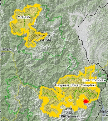
Per the morning briefing, the fire made a 6 mile run in the Coffee Creek area yesterday afternoon. They believe there was “significant” structure loss. 2 individuals who chose not to evacuate had to be rescued. There are also spots across the Cecilville Callahan Road. Focus of the day will be structure protection in Coffee Creek and Callahan.
I would post the IR map, but per the IRIN log, the north half of the fire could not be flown due to the smoke column. The IR map does not reflect yesterday’s significant runs on the north half of the fire. Similar weather expected today, slightly cooler with slightly higher humidity.
9 Likes
I tried importing their IR flight KML. Was pretty much unusable. I think your pics format on the 5th are better than I’ll be able to produce.
1 Like
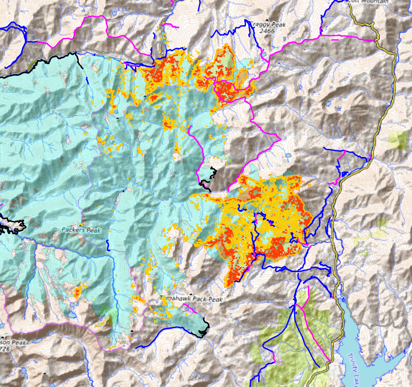
Using today’s data package, the northwest area of Trinity Alps area looks plausible:
Cyan = perimeter.
Black lines = Contained Line.
Blue lines = Completed Lines, all types.
Purple lines = Planned Lines, all types.
Yellow and Red = Heat Map.
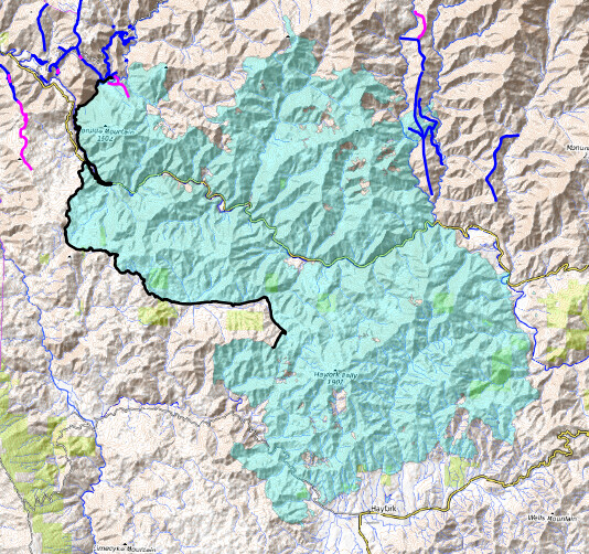
Monument fire area has even less line data than yesterday, no heat map, no lines on south side at all. Very frustrating when Hayfork intel is so important right now.
4 Likes
Haypress Fire has burned over the top of Craggy Peak and is slowly backing toward the lines protecting the Callahan area. Winds have decreased and fire activity has moderated, but there is concern that winds generated by tonight’s predicted thunderstorms could get the fire moving again.
5 Likes
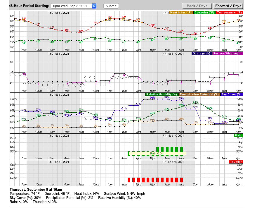
IMET reports 1/4" to 1/2" of rain across the fire. Should be an opportunity to make a lot of progress today.
13 Likes
192,109 acres. The lines held last night through the wind event. Rain coming this morning, we’ll see how much actually makes it to the ground.
9 Likes
Why are you asking if this is on the wrong thread? InciWeb shows 195,779 acres and 45% containment…
CIIMT 15 in briefs today at 1200. Shadow day Friday 9/24 and assume command (again) at 1900 on 9/24.
3 Likes
Well crap, looks like some new activity in Haypress. A Facebook post said someone in Lewiston called CalFire and was told a control burn. Seems a bit windy and a day before a Red Flag, but what do I know?
2 Likes