
DATA PACKAGE POSTED - MAPS.TAKSERVER.US
1 Like
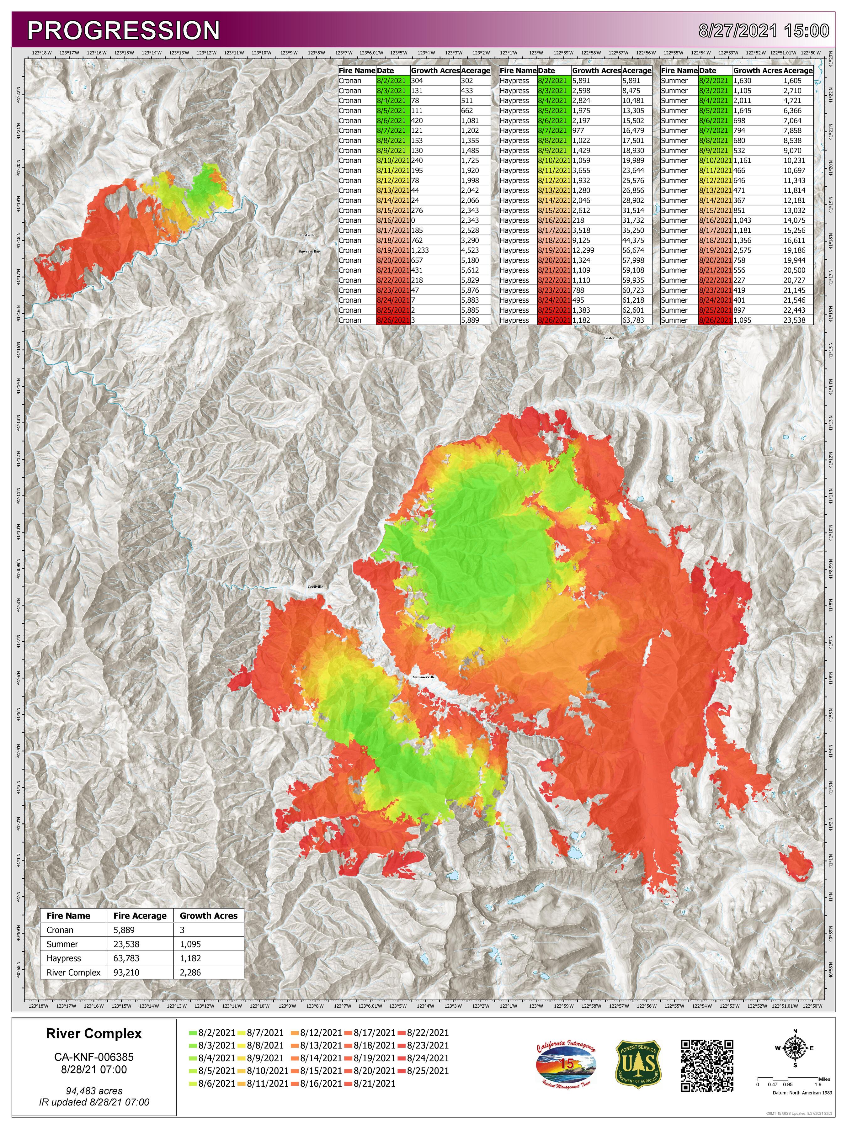
44,117 acres and 10% contained.
3 Likes
48,214 acres and 10% contained.
64,314 acres and 10% contained.
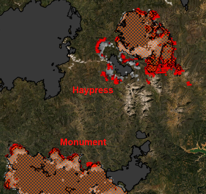
Significant growth on the Haypress, Cronan, and McCash fires today. It seems logical to assume they will become one perimeter at some point. Tomorrow the westerly winds increase and this will bring significant growth potential as the fires have spread south due to the northerly winds opening up more flank.
The Haypress continues to inch closer to the Monument Fire with VIRS/MODIS hits extending south.
1 Like
KML files filtered from 20210901 data package found here:
https://ftp.wildfire.gov/public/incident_specific_data/calif_n/!2021_FEDERAL_Incidents/CA-KNF-6385_RiverComplex/GIS/IncidentData/
For import into CalTopo, Google Earth, etc. Can’t vouch for how accurate they keep the data vs what’s really on the ground.
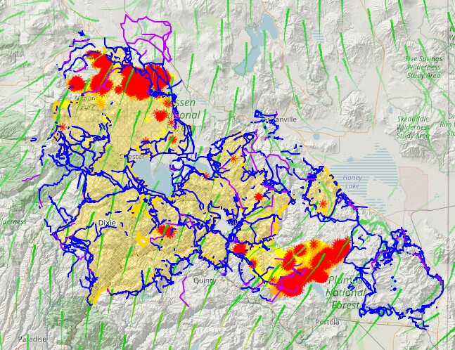
Completed Dozer Line:
Completed All Type Of Line:
Planned Dozer And Hand Line:
Here’s an example from Dixie data of what you can create with these in CalTopo. Blue lines are Completed All Type Of Line, Purple are Planned Dozer And Hand Line:
3 Likes
KML files filtered from 20210905 data package found here:
https://ftp.wildfire.gov/public/incident_specific_data/calif_n/!2021_FEDERAL_Incidents/CA-KNF-6385_RiverComplex/GIS/IncidentData/
For import into CalTopo, Google Earth, etc. Can’t vouch for how accurate they keep the data vs what’s really on the ground.
The table contains entries with the following incident names:
[NULL]
(River Complex)
Cronan (River Complex)
Haypress (River Complex)
Knob
Lava
McCash
Monument
MONUMENT
River
river complex
River Complex
Salt
Summer (River Complex)
Completed Dozer Line. There are 429 entries vs 399 yesterday:
Completed All Type Of Line. There are 777 entries vs 719 yesterday:
Planned All Type Of Line. There are 98 entries vs 105 yesterday:
Latest VIIRS along with some of today’s data package:
Red dots = Detection last 24 hours.
Dark Orange dots = Detection Last 48 hours.
Light Orange dots = Detection Last 72 hours.
Cyan = Fire Perimeter.
Dark Blue lines = Completed All Types Of Line.
Purple lines = Planned All Types Of Line.
Trinity Alps
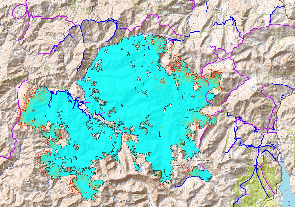
Monument
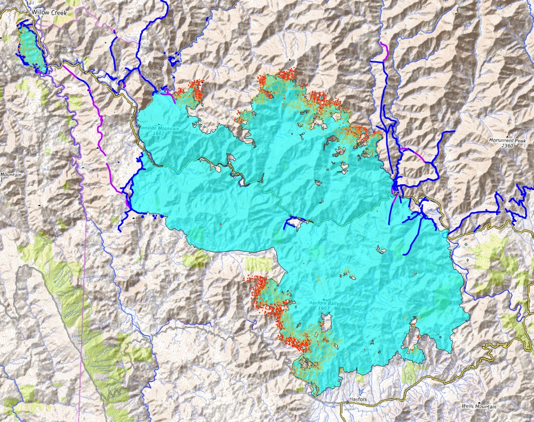
McCash

KML files filtered from 20210906 data package found here:
https://ftp.wildfire.gov/public/incident_specific_data/calif_n/!2021_FEDERAL_Incidents/CA-KNF-6385_RiverComplex/GIS/IncidentData/
I discovered the data packages are a complete mess from this incident. Lava and Salt info in one day, partly in another day, etc. These files are named v2 with Lava and Salt info removed. References to how many entries make up each KML vs yesterday’s are correct for today AND yesterday’s numbers. Who does this matter to? Probably only me LOL.
For import into CalTopo, Google Earth, etc. Can’t vouch for how accurate they keep the data vs what’s really on the ground.
Completed Dozer Line. There are 405 entries vs 339 yesterday:
Completed All Type Of Line. There are 694 entries vs 603 yesterday:
Planned All Type Of Line. There are 106 entries vs 96 yesterday:
2 Likes
Really appreciate all the gis work you’re doing. Tumbleweed and I both used your data yesterday and your dozerlines found their way into my video briefings for Caldor and Dixie.
13 Likes
They are requesting five to ten engines immediate need to Coffee Creek for structure protection.
Edit: Just upgraded the request to 20 additional engines, any type. Closing Highway 3 from Scott Mountain summit to Coffee Creek.
All air resources off the fire due to visibility.
7 Likes
Extreme ROS on both sides of Coffee Creek Rd, fire on the north side of the road is up to Billys Peak, 2 mile wide fire front to the south pushing down drainage. Now forming task forces in Coffee Creek proper, will assist law w/ evacuations. Wants those evac orders to be in line w/ the Trinity Lake east of Hwy 3, then warnings for east of the lake. Looking to get 50 immediate need closest any type engines due to life threat.
6 Likes
50x50 spot across the Callahan-Cecilville Rd on the northern end, more spots going across now, pulling back out of that area due to the conditions.
2 Likes
Hard closure of Callahan-Cecilville Rd at highway 3 CHP wants to keep highway 3 open for now.
3 Likes
3 Likes
Highway 3 is now closed at Callahan-Cecilville Rd.
2 Likes
Div Lima reporting a new spot in the s/w corner of section 9, near the ridge top, north of H-1
1 Like