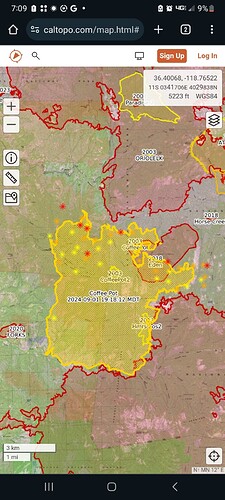
FW51 mapped it at 10101 acres.
No ir flight last night but FW51 was over the around 2pm. It’s now chewing slowly through the 2018 eden fire.
4 LATs ordered along with 2 additional type 1 copters.
50 acre slop in div.C is ringed with retardant and crews are requesting support.
Div. J, E and S requesting copters.
It’s that time of the burning period.
Monday 8am acreage was 11, 953 and they had a 50acre spot so, 12k +.
Estimated cost $50 million. Remains 17% containment. (per USDA).
Community Meeting tonight
Looking more and more like the SQF-CASTLE fire.
One tree seen burning for days…now $50,000,000 later…wow. Pretty high cost to the taxpayers for one tree no matter how you look at it.
Single tree strike that was lined and monitored? Don’t necessarily think it’s the NPS fault that roll out occured. After all they can’t control gravity.
I’m tempted to think the struck tree possibly had a dead top, was mopped up but was concealing heat.
All ground fire extinguished and then snuck out when it was unattended due to the belief it was completely out.
I’ve dealt with similar trees in the past, in my opinion if a tree is struck especially a fir even if it’s green you gotta cut it down and make sure.
Agreed. But what side of the fence are we all on? Everyone loves to bash the federal land managers for their “management” of fires. And we all know low intensity fire is beneficial. This incident hasn’t been all low intensity at times. For the sake of not being redirected by mods, I guess what I’m trying to say is let’s pump the brakes and let the feds do what they do in this instance. No homes have burned, and fire is introduced to a landscape that hasn’t seen it in ages.
Back to our regularly scheduled program.
I did not get the impression anyone was openly bashing initial suppression efforts. We all know S happens but, $4100 an acre?? As a taxpayer with no structure threat I’d say time to wrap this one up. Enjoy your day!
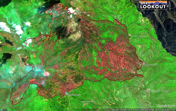
Here is a satellite fire severity map from a couple days ago. Yellow outlines are giant sequoia groves. Looks like the firing has been hot mainly in brush-dominated areas.
I’ll say this, I do not believe they tried to monitor this fire I believe they thought it was out. I also believe it should not have been monitored due to the activity at the time and the potential. They spared no expense hammering it with aircraft when it became active after it woke up sort of speak, which is why I believe it was never their intention. I’ve played on both sides of the fence and I can tell you we never monitored a single fire during FIRE season when I had those green nomex on.
I believe this was a surprise, and a bad one that it was still burning given the terrain, location, indices, and availability of resources. Not to say that everything happening from the fires presence on the landscape right now is bad however, it is ill timed and their tactics for suppression are based on safely achieving containment and probability of success. Not how many acres can be burned.
· Acreage at 19:00 mapping mission, 12,843 acres (+134 acres),
Grass, brush and timber, 23% contained (-2% containment)


