
Until all of the radio frequencies get squared away, I am using this online scanner: Northern California Major Incident. It has the Air Traffic as well as the Command frequency operational. What I don’t hear, is much for the West Branch. Keep in mind that since this is now being run as a single incident, the air traffic will all be through the same AA.
6 Likes
So far, command should definitely still be active on CMD 1 and LNU West. They are planning to move to CDF CMD 11 151.1675/103.5 eventually, so get that in the rotation. No timing, it could be mid-operational shift today since that’s in everyone’s radio load, or in the next op period or two…
1 Like
Does anyone have a decent shot of an ops map, or heat signatures?
Have a lot of family out in front of this thing and evacuated, trying to put their minds at ease.
2 Likes
Latest as of 0405
4 Likes
So I guess I missed the call. Running the whole thing on CMD-1 now. LNU West clear for new business. West has been assigned the double letter divisions. Will scan CMD-11 and wait.
4 Likes
Units reporting winds starting to pick up in many areas. Sounds like units have been doing fire front following most of the day to protect structures.
1 Like
Anyone know how City of St. Helena is looking? It seems it is about to be encircled, if I’m understanding the addresses called out on the radio correctly–correct me if I’m wrong.
1 Like
I too am curious…
I left last night when Boysen evacs were called (initially dispatched as a structure fire). Went back around noon – power is out but no impacts to St. Helena proper. Could see column through heavy smoke in Fir Hill area. Activity picking up this afternoon on both sides of 29 just north of town.
3 Likes
Did anyone catch the traffic regarding Annadel Park? There were crews working in the area and gave a report but the traffic was broken
Within the last 30 min, the inversion has lifted the entire East side has become very much alive.
http://www.alertwildfire.org/northbay/index.html?camera=Axis-StHelenaSouth&v=81e004f
5 Likes
Image from ABC7 copter captures smoke column beginning to break thru inversion layer.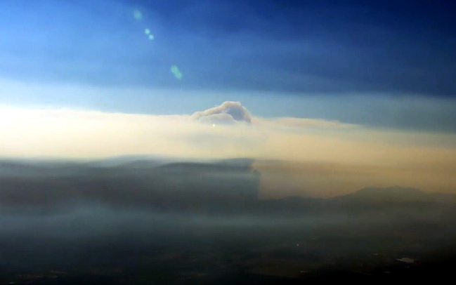
Can someone point me in the direction of the ops map?
1 Like
Nothing has been posted anywhere yet. The best available is what @Firedrone posted earlier in post 44.
3 Likes
Any idea of the homes at Bella Vita dr/Deer Park rd city of Angwin?
One of my FF has a house there.
As Dozer Keith stated earlier, please limit requests for particular home damage assessment. There are Damage Assessment Teams assigned to the incident and they will publish their work as quickly as they can. Everyone understands how much people want to know this info, but the purpose of this site is to exchange information about the fire’s progress and resources. It’s hard, but please try to be on the lookout for official word on the issue, usually from the county sheriff’s website.
High-Sierra
10 Likes
AA just said it is making a hard pushdown toward Calistoga he is going down to take a look. Mt. St Helena Cam has been showing steady build in intensity for last hour or more to the east slightly south of Calistoga.
4 Likes
36, 236 with 0%. How much is East or West, is not broken out. Rough guess would be 60/40 East/West
3 Likes
Has anyone heard any updates on the West Zone? Most of the radio traffic is focused on the East Zone. Looking at the cams there does not seem to be much activity going on in the West. Has anyone heard or seen differently?
2 Likes