Howarth Park, Spring Lake Park, and Annadel State park are all together and not much of a skip over hwy 12.
2 Likes
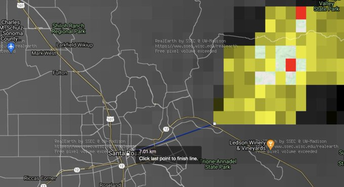
Nice IR heat progression on this tweet - shows about 7 miles from Hwy 12 area.
2 Likes
Howarth Park connected to Trione Annadel.
I live about 20 minutes away from there. From what they were discussing I’d say it would hit Trione-Annadel before Howarth Park. It would basically go through the State Park to get to the City Park.
1 Like
That’s what I was thinking also. I live in Bennett Valley myself so I’m gunna be keeping a close eye on it 
1 Like
Night Air Attack just reported a convective column at 12,500 foot level. Fire is plume dominated. Not at Highway 12 yet.
3 Likes
Spots up on Los Alamos and appears to be hitting back side of Hood Mt.
2 Likes
Which side is the Back of Hood Mtn?
1 Like
Evacuation warning just came over the tv for North and South Oakmont zones
2 Likes
Down to Los Alamos and Cougar, Starting to work on Evacs south of Hwy 12

Anyone hear what air attack just reported at 2156?? It’s all scratchy on my end.
Most likely the “north face” of the mountain ridge.
AA was talking about a TFR. Anything else was unreadable.
Copy thanks.
4 Likes
Reports it is crossed over Cougar lane and Sonoma SO can no longer cross Cougar. That puts it just a ridge or two from the Skyhawk Community.
2 Likes
AA radio traffic is horrible. I can’t copy anything hes transmitting.
AA reports needing crews in the Plum Ranch and Cleveland Ranch rd Area.
1 Like
http://www.alertwildfire.org/northbay/index.html?camera=Axis-HighHill&v=81e002f
(PepperWood West - High Hill)
Really ominous looking video from this cam. High winds have the smoke plume just hugging the hilltops flat/horizontal low elevation.
2 Likes