CA-LPF Ranch

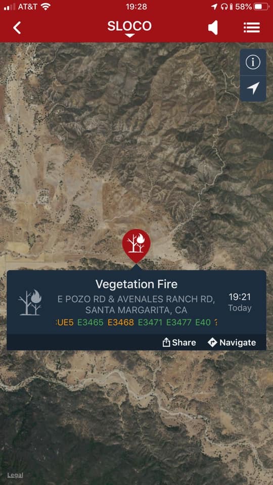
Satellite has been showing heat over what appears to be remote area of the Los Padres north of Hwy 166 in San Luis Obispo County. In the past these signatures have been structure fires but not sure there is much out there. Approximate lat/lon would be 35.11/120.10 Well east of Arroyo Grande and west of California Valley. (also well south and east of Lopez fire so not a rekindle) Any intel?

Listen here: https://www.broadcastify.com/listen/feed/30921/web

9 pm resource order: 10 closest type 3 engines, 3 dozers, 3 WT, PIO, and DIV

Veg Fire off of Pozo Rd east of Santa Margarita.

1 Like

Initial report 30-40 acres mros. Ranch IC. Additional equipment on order.

3414 is Ranch IC. Requesting additional 10 type 3 engines, 3 additional dozers, 3 additional WTs, 2 additional overhead and didn’t hear the rest. 100 acres, moderate ROS, potential currently at 500.

1 Like

RANCH IC has notified SLU that they have made a transition to the Los Padres NF as the ordering point and Command frequency change. LPNF ADMIN NET (171.5500), LPNF Tac’s 3-6 .

Any updates ?I do not see fixed wing on AFF, was there no early ups.

According to So Ops website 55 acres 45% contained at 0645

Wow, always amazing the numbers when daylight comes🤯