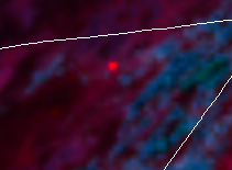
New start in the MDF?
Off HWY 139 north of the town of Perez. Pushing up against the power lines.
Any update on acreage?
Should be named CA MDF-Tucker. Unknown acreage.
Per Twitter 150-200 acers
Last rough estimate from AA, 1000 acres. Impacting high voltage transmission lines.
Screen shot from GOES West, looks to have some heat going.

Broken, but heard a large resource order go out.
I know for sure one of those orders was SHF dozer 29
Is there a better scanner link to listen to for this fire other than Broadcastify out of Modoc County???
This thread is for question and discussions about the fire. The Initial Attack thread that does not have question marks in the Title is for Fire information only. Let’s keep questions here and factual fire information in the other thread. Any good fire should have 2 separate threads. I understand the frustration of sorting through questions, however that is what the question and discussion thread is for. Let’s keep the questions related to the fire though.
Any idea if this was a hold over from last weeks lightning activity?I
So far no team order as far as I can see. Thinking maybe they are keeping it local unless it makes some more runs today?
The spot fire from earlier is making a run. Large column on division alpha, looking for a new game plan.
Column/Plume visible from Redding presently
Confirmed w imagery from GOES 17
“Gasoline Alley” area
Per cad at 15:42 today its putting the fire at 11000 acers, can anyone confirm?
Per inciweb 11,000 acres.
Looks impressive on goes 17
https://www.star.nesdis.noaa.gov/GOES/sector_band.php?sat=G17§or=psw&band=GEOCOLOR&length=12
What was the activity like today? Or did it go out when the team arrived
