State ID:CA
3 letter designator: MMU
Fire name: Auga
Location: Hwy 140 and Agua Fria Rd.
Reported acres: 2
Rate of spread: MROS
Report on Conditions: grass, brush oak woodland fuels
Structure threat: yes
Resources: MMU
Hazards:
Weather:
Radio channels: AT22, CDF command 1
Scanner link:
Webcam link:ALERT Wildfire, ALERT Wildfire
Agency Website:
3 Likes
IC on CDF Cmd1 ordering four type 3 strike teams engines, 6 dozers, 4 strike teams crews.
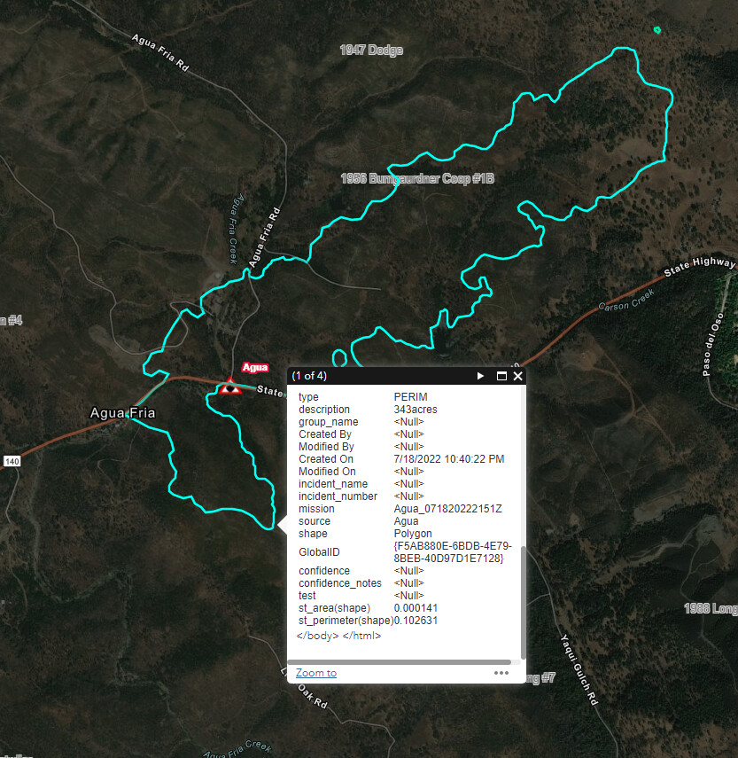
50 acres.
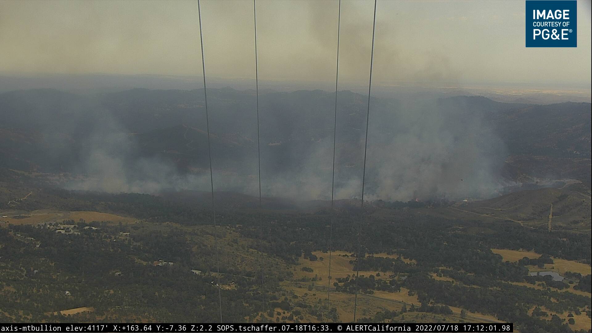
Spotting beyond the head. Shaping up to be extended attack
3 LATS enroute
EDIT UPDATE @ 1420: VLAT and Lead ordered by IC
5 Likes
Per IC - 50 Acres, Moderate to Dangerous ROS on both sides of Hwy 140. Requesting an additional 20 engines, 8 crews, 6 dozers and 4 battalions.
6 Likes
RAWS Mariposa explains the spread rate:
Avg wind 6.0 mph
Wind out of 154
Peak winds 15.0 mph
Air Temp 98.0
Fuel temp 113.0
10 hour fuel stick 3.4 (critically low)
RH 14
EDIT UPDATE @ 1430: 5 copters assigned per AA
6 Likes
AA talking with IC hoping to catch it when it Transitions for brush to grass. Hopefully gets some dozer out in front and some drops in the grass. If not, then it goes back into brush.
5 Likes
Burning in the Detwiler burn scar from 2017
8 Likes
Plenty has grown back and this area burned pretty spotty
4 Likes
It’s looking better if they can catch those spots and take the heat out of the head and the shoulder they just might get on top of this one.
3 Likes
Diverting 2 tankers for new start in TCU
2 Likes
Tanker 132 was stating that the spots are being enveloped by the head.
4 Likes
I saw that developing on cam, hoping they could slow it down. Now its making another good run.
4 Likes
More spots out front
3 Likes
New spot between Bumgardner and Yaqui Gulch
3 Likes
Agua Fire Information: Click link for Details https://evb.gg/n#f3llllrrmq6
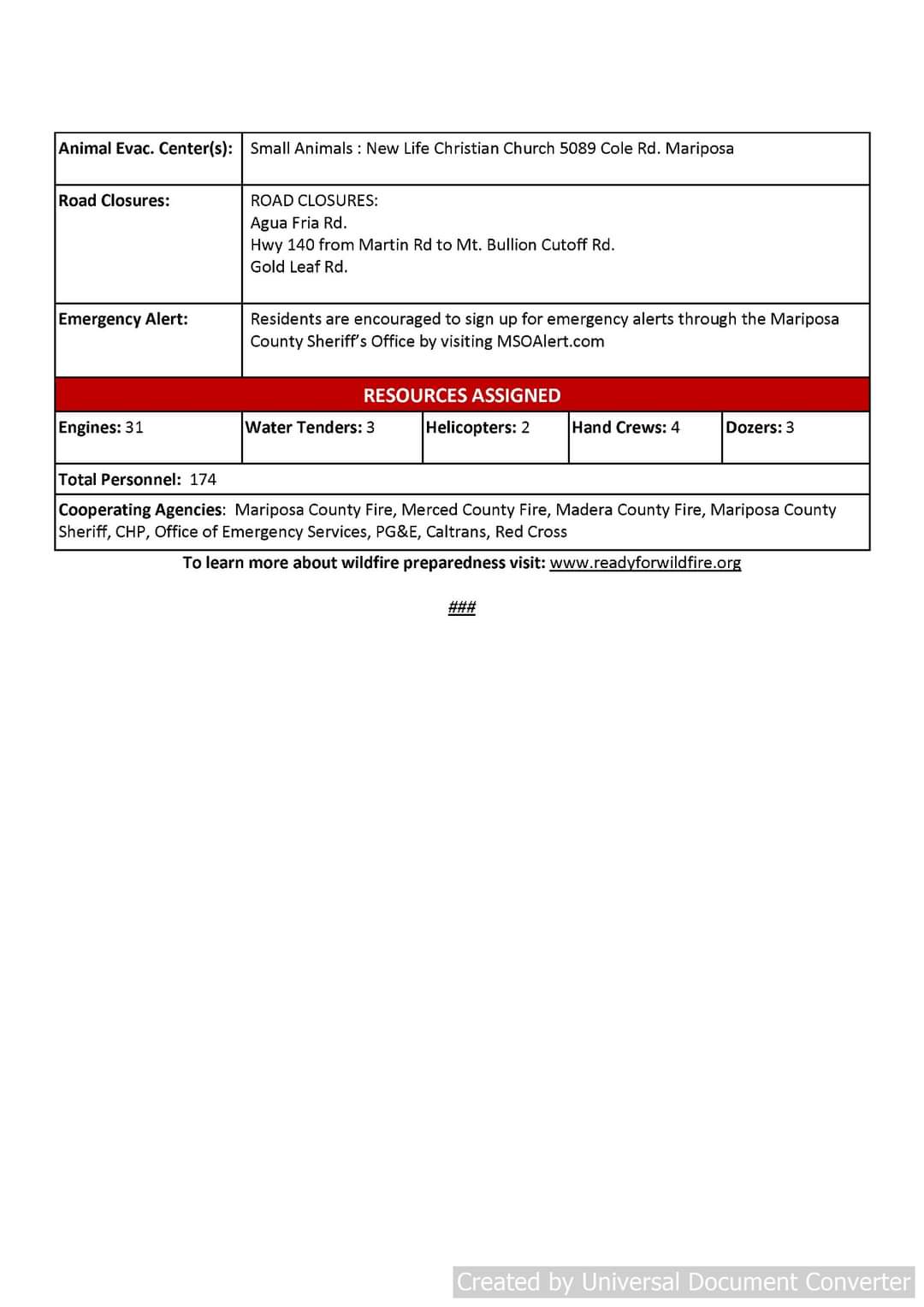
Evacuation Order: All of Agua Fria Rd and Gold Leaf Rd
Fire Advisement Area: ( This is not an evacuation order, it is simply to notify residents in the area of the potential need to evacuate should conditions change allowing them to begin to prepare). Mt. Bullion CutOff, Hwy 140 from Agua Fria to Bumgardner Rd, Live Oak Rd, Yaqui Gulch Rd from Hwy 140 to Live Oak Rd.
MAP OF THE AREA
https://arcg.is/1Ofr4T
ROAD CLOSURES:
Agua Fria Rd
Hwy 140 from Yaqui Gulch to Hummingbird Ln.
Gold Leaf Rd.
Video- Axis-Bullion | Sierra & Foothills | Regions | ALERT Wildfire
Red Cross Evacuation Center has been established at the New Life Christian Church located at 5089 Cole Rd
2 Likes
AA is releasing a couple of tankers, 1 LAT and T83
EDIT Update @ 17:00 all but 1 LAT released. 914 returning and 103 enroute, that will be the last drop.
5 Likes
Update 5:30pm 7.18.2022
The fire is showing significant improvement. It is still holding at approximately 343 acres and is 10% contained. The resources on the fire will be committed through the night. Fire managers will be meeting soon to discuss the plans for tomorrow.
5 Likes
They have retardant, dozer, hose etc around the entire fire. All the tankers have been released. AA504 is AA now. 3 copters still working until pumpkin hour.
3 Likes
Can’t reply cause of the “3” rule so editing here


All aircraft are off the fire
#AguaFire off Hwy 140 & Agua Fria Road, west of Mariposa in Mariposa County is 300 acres and 10% contained.
CAL FIRE Madera-Mariposa-Merced
6 Likes