The people in this area have had huge issues with pg&e contractors coming in and taking a lot of trees down and then leaving them for the property owners to deal with and as was mentioned before the type of people in these areas don’t have the resources to deal with this. I’ve watched countless discussions about this over the years. They’ve had no luck getting assistance. I’ve personally seen the ramifications as well on my friends properties. I’ve also watched my friends who owned tree companies close their businesses because it’s gotten too costly to run those anymore due to things I won’t bring up in this discussion.
That’s a problem we have been addressing in Tuolumne County for a long time. But what I’m talking about is the casualty from the drought. It was just a massive amount on the ground and standing on fire.
Bark beetle too
Don’t forget we had low snow in late Dec. that took down a lot of trees or broke branches that hung up in the canopy taking a species of trees “oaks” that are resistant to crown fire and now we have a high potential for crowning
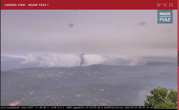
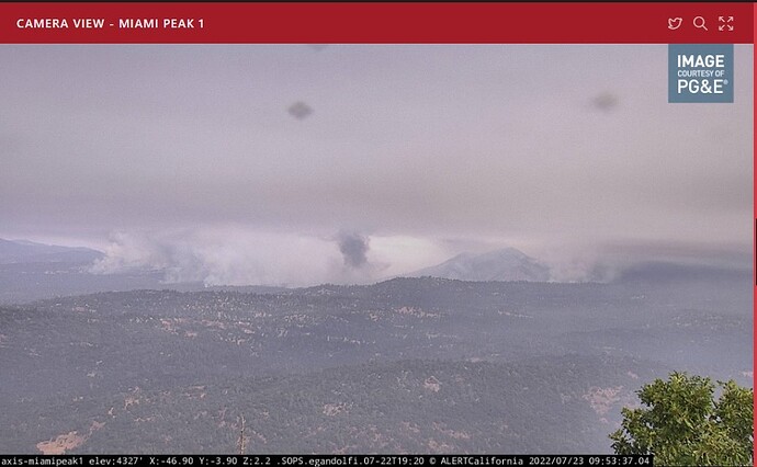
Screenshots taken moments ago (07/22/2022-9:55am) of the Oak Fire from the MiamiPeak1 cam. Note the imbedded dark smoke. Structure burning?
You can never know the actual conditions on the ground from aerial photos so this is situational dependant. When assigned to “structure defense” never pass up an opportunity for perimeter control. Several areas showing slopes or spots just over a roadway that was holding for the most parts are visible in various aerial footage. Lots of red lights back at structures but not at the slop or spot. Putting those out can go a long way in defending your structures and may help secure some line.
The low elevation, snow broken branches have been on my mind also. Also there was a late freeze up here (Grass Valley) that froze the new tender leaves on the black and blue oaks but they did not drop. Then a new crop of leaves came a month later but it was warm and dry by then so the new leaves do not look so hot either. I suspect that adds a layer of light flashy fuel to the canopy. Are others seeing this?
I manage fuels for radio sites from Auburn, Mt. Bullion and Auberry/Meadow lakes and I haven’t noticed that oak damage.
Does anyone know where I can find an updated link for current evacuation orders?
Thanks  much appreciated for family friends
What concerns me is this is a Mariposa county maintained site. Notice the information drops off at the county line and is grayed out. Madera county needs to step up and get theirs going.
MadCo is more than ready to act, when necessary. Unfortunately thwy have had multiple incidents of large inciden†s annually since 2015.
Latest spot weather shows South to Southwest winds and eye level and transport. This may change my initial assumption for a northwest push today.
https://www.weather.gov/spot/php/forecast.php?snumunum=2215581.0&lat=37.68725102021804&lon=-119.70933709643491&z=9
@YardDog11, Sorry, I should have been more clear. From receiving them I know they’re very active with the MCALERT system. I just don’t remember ever seeing any GIS site associated with it, I’ve always had to open a map and try to place where they were discussing. I was hoping for that, unless my memory is getting worse and they already have one?
Pick a spot, any spot.
Is that site of your screen shot you show of the INTEL-24 publicly available or only agency?
@moderators thanks for moving that and if its ok I will answer so everyone know how this works.
We are using ADS-B exchange data and have it sent to a TAK-SERVER and its filtered for public safety aircraft and we have a script to add the aircraft call sign, icon type for helo or fixed wing and then wether its an Air attack, air tanker, Intel ship etc.
Right now this is on a testing and evaluation server and ADS-B exchange has been gracious with an API Key because we are supporting public safety. If someone want to use ADSB Exchange data for profit they charge a pretty hefty fee.
I would love to release this TAK-SERVER certificate at a later date when this hosted in a non T&E environment for everyone to use. In the current configuration it is basically a feed and your location is not shared so you have some privacy.
Now you can track all these aircraft outside of ATAK of course with flight radar 24, adsb exchange etc but having it in ATAK is pretty nice because you have the call signs, is filtered so you dont see all the other aircraft, you get all the other layers and maps, can get live ETAs using the blood hound tool etc.
Axis-YosemiteWest | San Diego | Regions | ALERT Wildfire
Look at Cam view for the current fuel loading in a portion of the 2018 Ferguson scar.


