CA-MMU-OAK???

Yet another view:

Axis-Edith | Sierra & Foothills | Regions | ALERT Wildfire

2 Likes

1300 acres

3 Likes

Hardly an hour apart and the fireline has already crested the peak of the ridgeline and appears to be spotting down near Triangle Road. Dont take that as fact, that’s just what appears to be happening anyway.

3 Likes

It’s past that area now and and will be playing a factor, right now it’s on Buckingham mountain which is just barely visible at the base of the column.

3 Likes

Watching the three hour loop on Mt. Bullion Camera 1 shows impressive spotting and then consumption of the lee side slopes.

1 Like

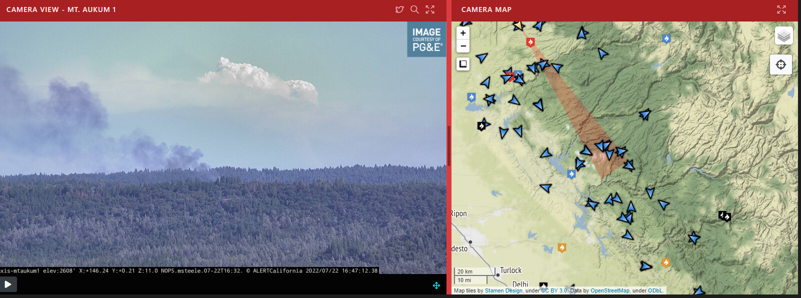
You can see it much further away too from El Dorado County. The fire in the forefront is in Amador County…you can just make out the column of the Oak Fire…at first it looks like clouds.

6 Likes

The heal / origin is showing on Caltopo:
(Usual 3 hour delay for signatures. Also smoke will give some false heat signatures with this size of fire -FYI )
https://caltopo.com/map.html#ll=37.52583,-119.89049&z=14&b=t&o=f16a%2Cr&n=1,0.25&a=mba%2Cfire%2Cmodis_mp

3 Likes

Ferguson was in Yosemite National Park. This is right outside mariposa. This is southwest of Ferguson Fire

2 Likes

The Ferguson fire was pretty much all on the sierra and Stanislaus national forest except where they held it at highway 41 which isn’t far from the western boundary of the park.

Oak fire is into the Carstens burn now.

2 Likes

Ash falling in FKU.

6 Likes

Lots of regrowth and a lot of grass in the Ferguson, at least on the Stanislaus

3 Likes

Same way on the sierra side.

2 Likes

Not good…ice cap is visible from Sacramento…be safe

12 Likes

Column definitely dropped quick and is leaning back over triangle road area.

3 Likes

They make there “big resource” order that they were working on yet?

1 Like

Region 5 OES’s being called

9 Likes

Going to impact Lushmeadows soon. crossed snow crk multiple locations. Fire is established on the S side of triangle. Spot across Triangle toward Jerseydale. All unotunit Darrah and Triangle Rd keep heads on a swivel

3 Likes

Here is a perimeter of the Oak Fire.

1 Like

What time was this created? Based on the information from @trishaswcfirewx and what I’m hearing on the scanner the fire is well beyond what your map is showing. It might be good to indicate the time maps are created or when the intel was gathered - particularly when a fire is moving as fast as this one is.

7 Likes

Multiple spots across the Oak creek drainage

2 Likes