New fire in MVU in the Dehesa area. Good column showing on the Lyons Peak CAM.
1 Like
This is near the area of Dehesa Rd near Sycuan Summit Dr. Initially reported as 2 acres with MROS
1 Like
IC has ordered 2 additional Copters.
Current weather conditions near the fire: 79 F, RH 55%, west winds 5 mph gusting to 15 mph. IC states no current structure threat but that may change in 45 minutes.
EDIT: 25-30 acres and slope driven.
2 Likes
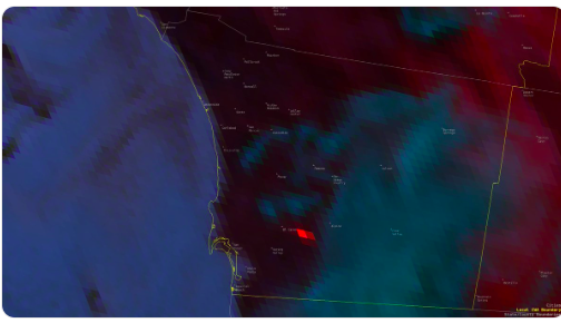
Heat signature.
1 Like
N160aq black hawk, n217ac skycrane, and 2 snd sheriffs copters.
Immediate need Type 1 ST from Heartland assigned. 35-40 acres, will make it to the ridge then need to back down for next structure threat per AA. Potential of 500
1 Like
Per the IC the fire is now estimated to be 50 acres and 0% contained. 3 homes have been evacuated along Dehesa Rd but no evacuation warnings or orders have been issued. There are no homes that are currently being threatened.
3 additional crews and 5 closest Type 3’s
1 Like
Forward progress stopped at ridges, Tankers on load and hold
Morning Update from MVU: The incident commander is estimating the fire to be approximately 150 acres and 50% contained. The fire will be mapped later this morning and a final, more accurate acreage will be determined.