State ID: CA
3 letter designator: MVU
Fire name: SawdayP
Location: Sawday Truck Trail /Witch Creek
Reported acres:
Rate of spread:
Report on Conditions:
Structure threat:
Resources:
Hazards:
Weather:
Radio channels:CDF CMD 2 Tac 5/8
Scanner link:
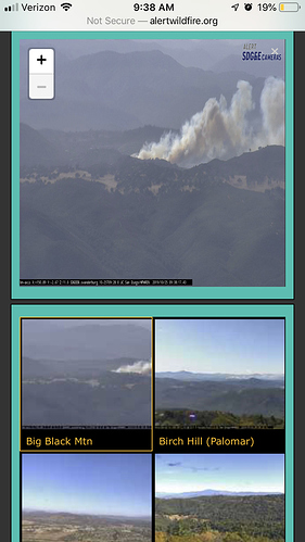
Webcam link: http://www.alertwildfire.org/sdge/index.html big black mtn
Agency Website:
At least 5 acres, dangerous rate of spread.
Five acres, critical ROS, numerous structures threaten, one burning and reports of residents trapped. MVU2
10 additional engines . Request for two type 1 copters
Air Attack at scene reporting way to turbulent for fixed wing and will need to shut them down. Copters enroute
Weather Conditions: Goose Valley
Temperature: 78 °F
Dew Point: 9 °F
Humidity: 7 %
Wind: E at 20 MPH
Peak Gust: 36 MPH
AA requesting three additional type one helicopters
From HPRen Cam on Big Black Mtn.
http://hpwren.ucsd.edu/cameras/I/bm-s-mobo-c.html
Column is lying over nicely
Monte just advised two of the helicopters can’t lift because of wind. AA stated he would be putting a request in for a lead to assess for FW
yeah this one will be a corral’er and try to hold at Hwy 78. Reminding me of the speed of the Cedar Fire.
Heard OPS want to hold it at Sawday truck trail a few mins ago. Just heard AA state it just spotted across it
Birch Hill
Big Black
Cowles Mtn.
Mt Woodson CDF
http://www.alertwildfire.org/sdge/index.html
Also in response to Rotor wing not being able to lift off, AA said he’s not sure he can even work rotors due to wind at the fire also. 
EDIT- also, FYI, if you use alertwildfire.org cameras from a smart phone, it likely stretches the image 50% taller if you hold your phone vertical.
Turn your phone sideways and you’ll get an accurate image.
Two more type one helicopter for a total of 7. And one type two helicopter and lead plane
75 acres , critical ROS, potential for extended or major
1 ST C 2 dozers 2 crews requested by branch I
There is another fire in front of the or side of the main start. Look at the cam. Mexico fire in the back ground. Los Pinos cam in the foreground.
Crews are attempting a backfire
