North-Ops has it as a PNF incident.
CA-PNF Fly Fire: 1,200 acres timber, 0% contained. Structures are threatened with Evacuation Orders and Warnings in effect. Highway 70 is closed.

North-Ops has it as a PNF incident.
CA-PNF Fly Fire: 1,200 acres timber, 0% contained. Structures are threatened with Evacuation Orders and Warnings in effect. Highway 70 is closed.
As it’s being managed by PNF. Wondering if they will just attach/keep the resources off Dixie or add to the list of pending orders already sitting in the system.
This is being handled by CIIMT 2, the team now assigned to the east side of Dixie.
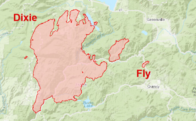
The Fly does not line up with the main fire, and not sure of the exact distance but certainly has to be several miles plus, what are/were the prevailing winds doing yesterday, speed and direction, just seams a little odd is all. regardless they have there hands full to be sure…
It would have been helpful to look at the time-lapse first and now that i have it still does not line up as a spot, looks to to be a new start, probably mistaken, it just not lining up… ALERTWildfire | Shasta Modoc
I looked for another angle but could not find one…
In going with hold over.
Or just plain ol’ human buffoonery - even worse if it’s of the intentional variety. With the roads in/about the origin area, add mechanical to the list. And of course with transmission lines also in the proximity, I’m sure everyone’s favorite utility has experts anxious to rule out their infrastructure.
The clues and patterns are likely still there. The prevention wizards will ferret them out, place the arrows, take the photos, and come to a conclusion to fill the text box on the report.
It’s a time-honored tradition 
Per the OPS briefing Fly is a new start. Not a spot.
The Fly Fire is 1,650 acres and 0 percent containment. Last evening crews quickly diverted from the Bucks Lake area to assist with the Fly Fire.
Winds are calm from 10m-100m above the surface.
Cams are showing smoke out conditions.
East Quincy cam showing header.
Thanks for that info…I thought it a little peculiar to be a spot, sure hope it was accidental in nature…
Gusts are picking up and upwards of 12mph over the fire area. May start to see under the smoke column for tanker use and intensity may soon follow.
See my post with Ventusky above for compiled wind speed and direction.
N.Cal RAWS Map for each station:
https://wrcc.dri.edu/wraws/ncaF.html
The Fly has developed enough energy to pull the Dixie. It is very evident on the East Quincy 1 hr time lapse. Quincy is just about to be completely closed off with ground smoke from the two.
That was an amazing hour time capture… reminds me of the morning of the Esperanza fire when the fire ran sideways over us… dark till 2 PM
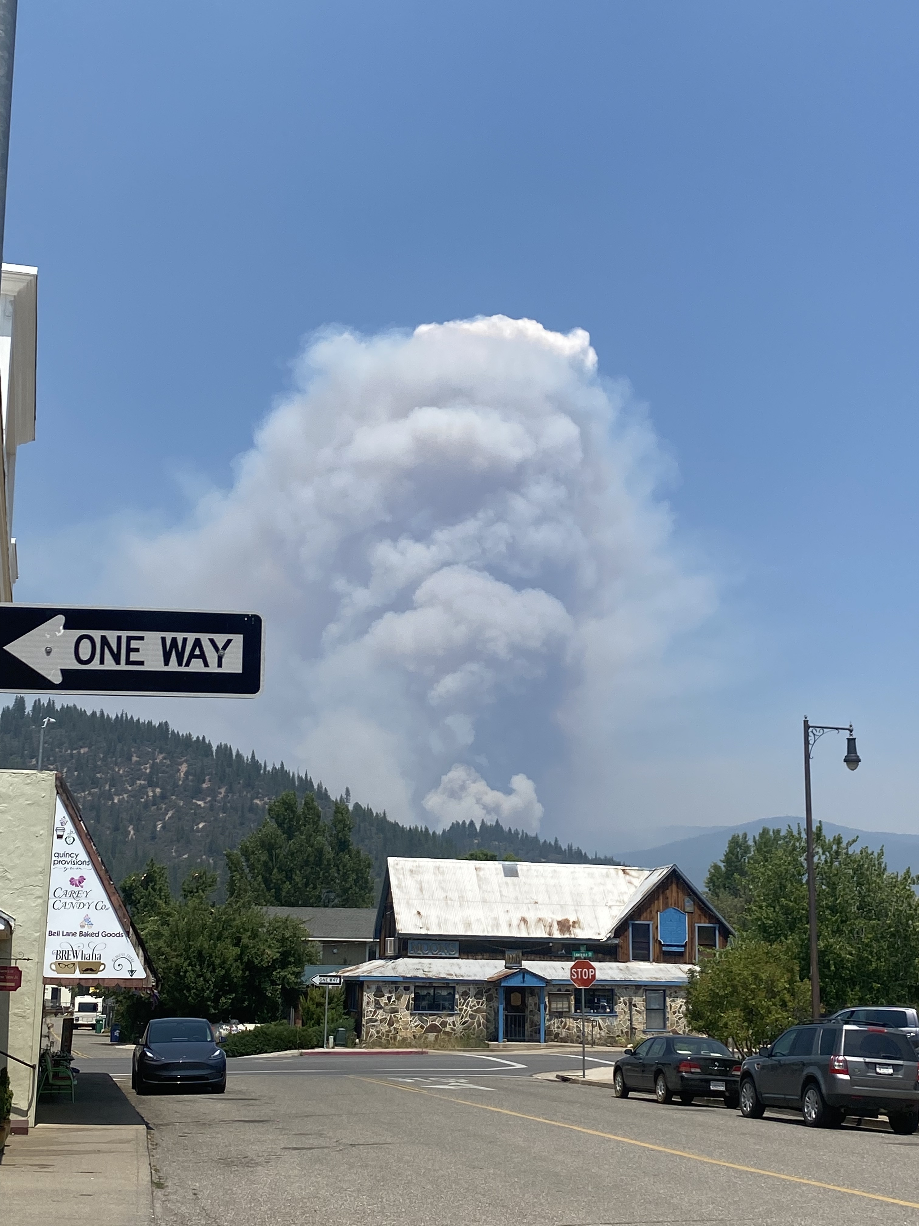
I assume I’m seeing the Dixie Fire plume in the background? Absolutely devastating!
The Fly Fire reached nearly 2,800 acres and had demonstrated extreme fire behavior overnight, as did the Twain portion of the Dixie Fire. The area near Twain started as a spot fire from the Dixie; the Fly Fire is not a spot fire, and the official cause is still under investigation.
Dennis Burns, the fire behavior specialist for the East Zone of the Dixie Fire, updated both areas of the fire this morning, July 24. He said that though the Fly Fire exhibited extreme fire behavior overnight, it did not push toward Quincy. In an earlier briefing today, fire officials feared that it could reach Mt. Hough within the next 24 hours.