
Thanks for the map…
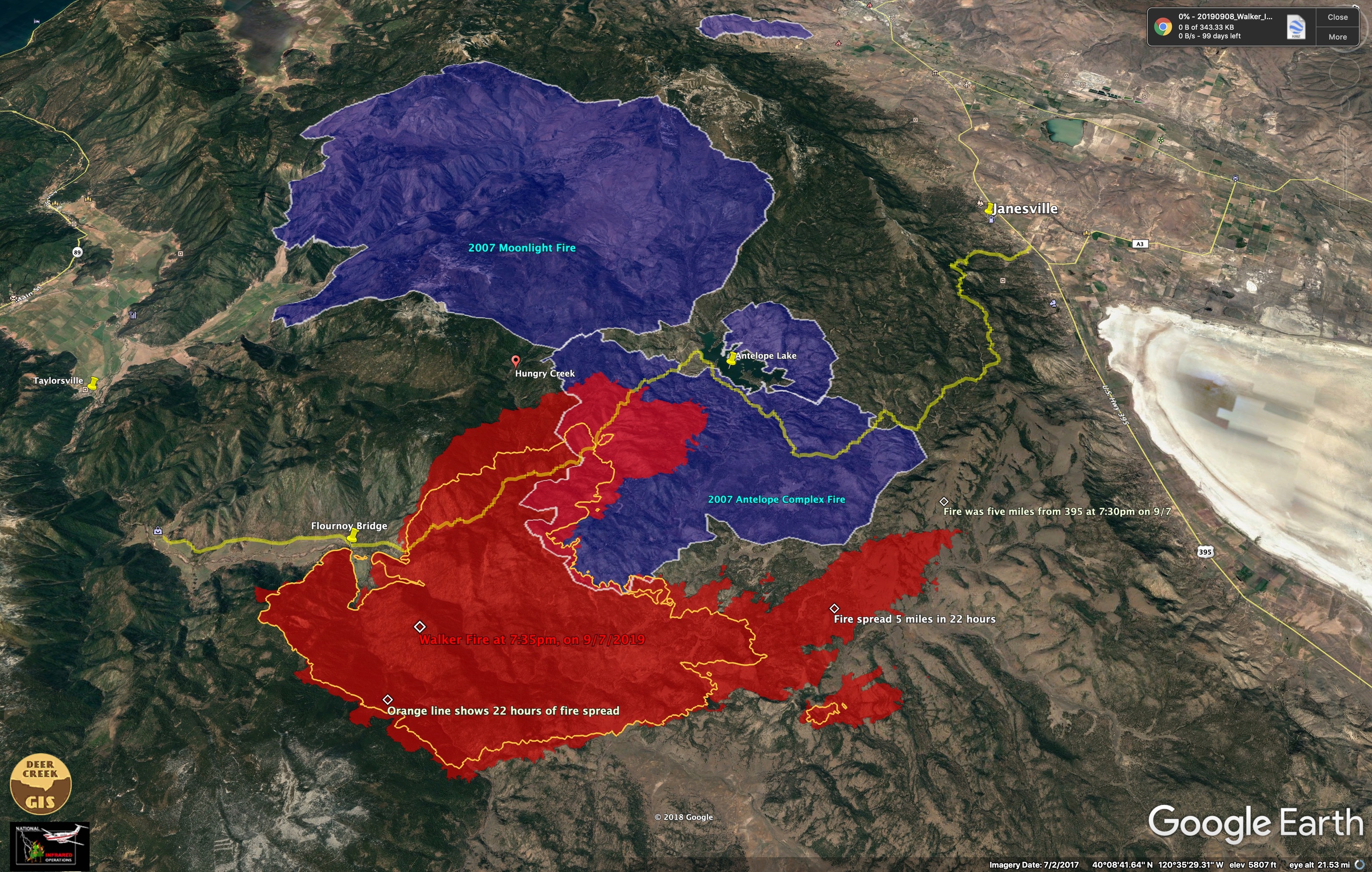
Walker Fire was mapped last night by the National Fire Center’s IR crew. 7:30pm, 9/7/2019. Here is a map we made based on this data.
Walker Fire is red.
Orange line shows 22 hours of growth since last IR mapping.
Yellow line is the Janesville Grade/Antelope Lake Road.
Blue areas are the 2007 Antelope Complex and Moonlight Fires.
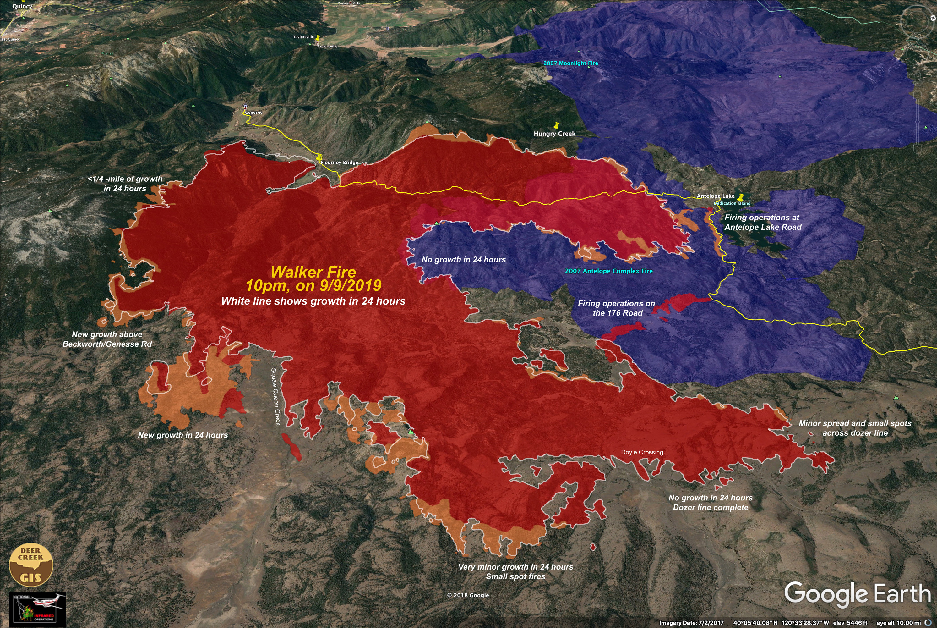
Fire spread was slower in the 2007 Antelope fire area than in the unburned areas to the south. The fire advancing about 2.5 miles into the Antelope burn along the Antelope Lake road.
The fire spread 5 miles to the east in 22 hours, and was five miles from Highway 395 at 7:30 pm on 9/7/2019.
Size at time of mapping - 38,000 acres.
11 Likes
Forecasted weather next 2 days (Mon-Tues) hopeful some relief. Low RH >30%. Mixed bag if thunderstorms develop. Wind but some moisture possible Tues. Watch out Wed thru Friday though. Farther east light fuels respond so well to higher RHs. Mixed bag on escarpment winds. More than likely mentioned during briefing given that those winds are mentioned on the Fire Danger Pocket Cards (at least they were a few years back.
2 Likes
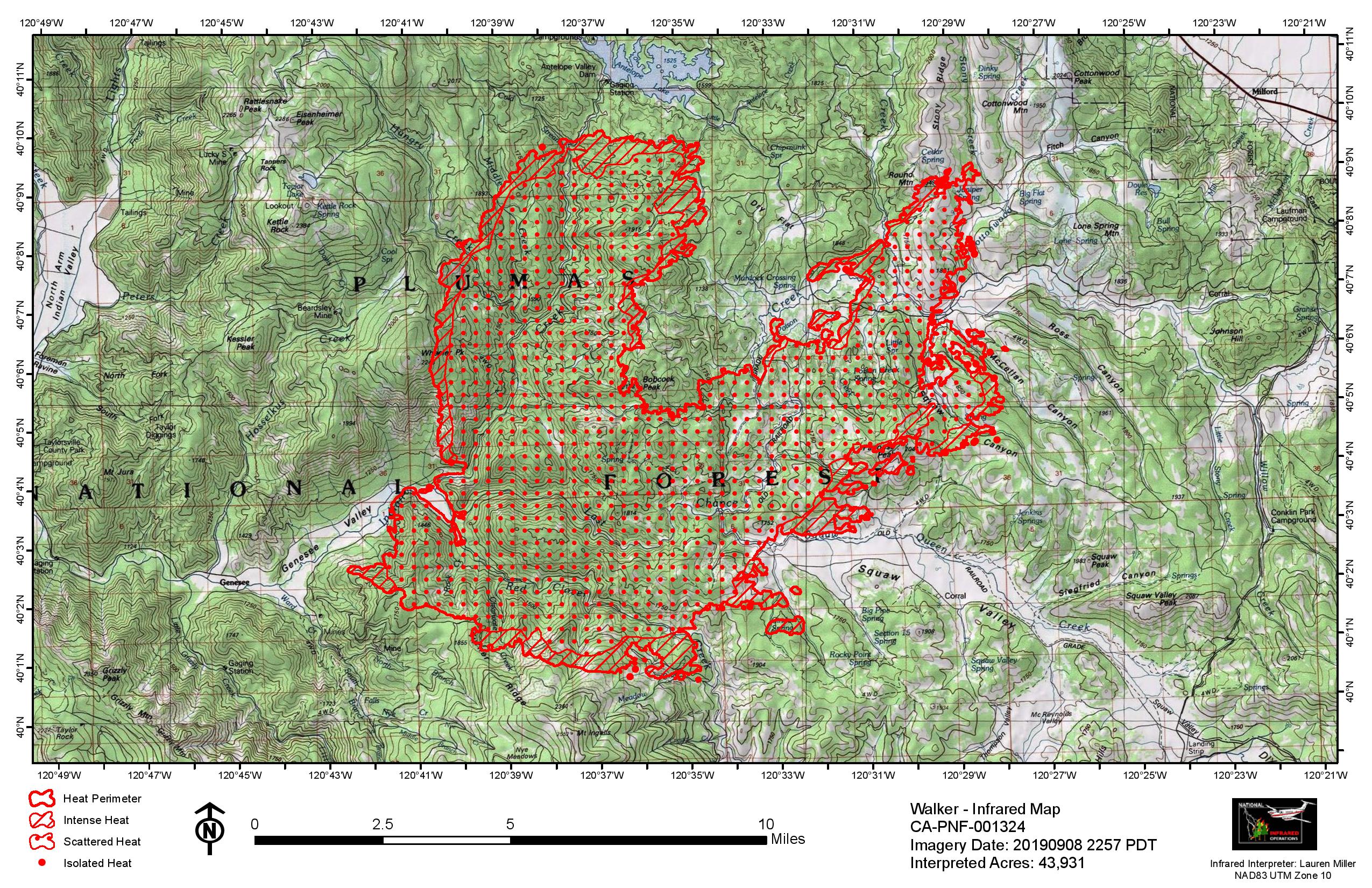
43, 931 acres per the IR flight last night. Here’s the map:
1 Like
The fire got rain on it last night, enough to put puddles in fire camp.
2 Likes
Actually got rain in camp this morning more expected today
9/12/19 @ 0700: CA-PNF Walker Fire: 49,272 acres grass and timber, 28% contained. In Plumas County Evacuation Advisory remains for the Flouroy Bridge and Franks Valley area and Mandatory Evacuation Order remains for Murdock Crossing, Stoney Ridge and Antelope Lake areas. In Lassen County the Evacuation Warning remains along Hwy 395 from Laufman Grade to Wales Canyon and the Babcock Crossing area. Threat remains to the 5 Bears Hydroelectric project in Ward Creek and the Walker Mine Super-fund site.
Looking at Ops map for 9/13 and things look pretty good. Front forecasted for Monday w/precip. Winds ahead of front will test lines Sat&Sun nor doubt and if they hold the Walker is all but over. And nature will do what it does best after a fire. There is that pesky unburned pocket to deal with, I suppose. IMHO
1 Like
Smoke showing on the Dyer and Fort Sage cams. Looks like it woke up a bit (unless they are burning) and has some wind on it.
VLATs worked until sunset last night…
No VLAT’s flew the fire yesterday. At about 1700, 5 LAT’s (RDD, CIC, MCC) were ordered to the fire and flew until sunset.
…looked big (lol) MD-87 I think then…
Pages 57 and 58
1 Like

Team 10 taking the fire. In-brief tomorrow-9-19 @ ICP
Unit Leaders and above only…
1 Like
Short Team?
1 Like
That is the intel I received…
26 folks for a short team