
Look at the post above your initial post. It lays out the exact order for tomorrow by the IC, which includes 6 S/T Alphas. Right now as immediate need the IC will request individual engines as he/she will get them faster than ordering by S/T configuration. Tomorrow S/T orders make sense as they have time to form and travel.
6 Likes
Exactly what i heard CAL Fire Type 3 then he reaffirmed by stating local Riverside Type 3 for 7am
3 Likes
Makes sense, most units can or have enough staff for a Type 3 in Unit team. Team 5 is on hard cover but wont be activated unless RRU submits for type 1 team to region. Office.
3 Likes
A lot of areas are establishing type 3 IMTs to manage short term incidents as well as the initial evolving incident prior to a Type 1 IMT coming in and taking the incident. Most of these teams have type 1 qualified personnel on them as well. I know of the North Bay IMT AND the Sacramento Regional IMT as good examples of established type 3 teams outside of the federal system. Don’t mean to digress from the incident at hand.
6 Likes
Ahhh I gotcha. Awesome they have a local IMT-3
1 Like
Anyone got an updated acreage? And possibly a pocket card or nomogram?
Night AA mapped it roughly to 1550 acres
Does any know where ICP is??
Noble creek park at 0100
1 Like
Thank you!!
Monsoonal flow coming up the Coachella valley this morning
Muggy and reverse wind direction
1 Like
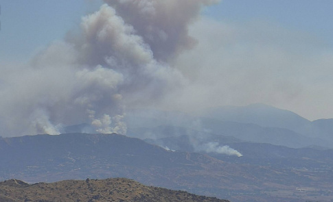
Looking at the camera for the Apple incident
http://www.alertwildfire.org/inlandempire/index.html?camera=Axis-RechePeak2&v=81e003f
it looks like there is a second smoke in the background. What is it?
1 Like
That’s one of three fires burning from yesterday . Fire #1 was contained but 2 and 3 continue to burn. It’s a branch within the Apple since it burned together .
2 Likes
No, this on the border of Cherry Valley, Oak Glen and Yucaipa. Its a weird little section on the county line.
For those who know the area, it would appear that the air flow is moving it laterally to the East roughly along Bluff Rd. Is that fairly accurate?
1 Like
It’s waking up.
Nearby PWS reports 93.2 degrees RH 16% Winds SSE 8.1 MPH
3 Likes
Depends on what you mean “near”. Yes, it’s in the same Banning Pass roll area, but miles away. on the opposite side of I-10. Silver fire was south of towns in the pass, Cherry Valley is north side.
2 Likes