15000 Gilman Springs Road. 50 acres in light flashy fuels, potential for 1,500 acres. Wind driven under a Santa Ana condition.
5 Likes
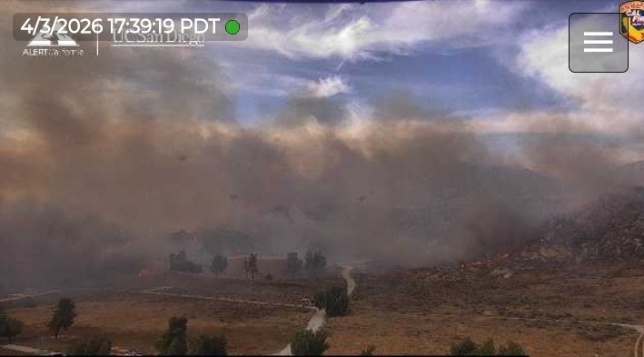
Sounds like it jumped Gilman Springs Rd. Additional Tankers requested. View from the other side https://ops.alertcalifornia.org/cam-console/1848
Another angle of the column bending over in the wind, Ranger Peak.
https://ops.alertcalifornia.org/cam-console/2295
5 Likes
Looks like its going to hit lake Perris, sounds like they are going to evacuate them now.
4 Likes
IC requested 10 additional type 3’s and 5 more any type engines.
3 Likes
1,000 acres now. Burning on Mt. Russell north of Lake Perris.
1 Like
AA also advised 2 more tankers coming from Sacramento. I believe they are C-130’s.
5 Likes
Two LATs from MCC were on order, one was diverted to the LAC fire.
2 Likes
T122 diverted to Crown T120 on Springs.
2 Likes
1500 acres and an immediate structure threat at Del Lago and Moreno Beach in Lake Perris. 10 additional engines to that area.
3 Likes
LATS coming from AZ and NM. T12 and T 131.
1420, ORCO Copter 2 en route.
3 Likes
Lake perris camera.
3 Likes
Looking grim there, man. I hope we don’t see flames coming over that hill. A buddy of mine lives around the area of that camera.
3 Likes
Intel24 is mapping the fire now.
5 Likes
2817 acres currently.
4 Likes
3,500 acres and 5%, looking a lot better.
4 Likes
Fire is visible on the ALERTWest - Lake Perris North cam.
Additionally, this is just rumored, but someone on Facebook did say that structures were impacted including the nearby high school, but I think this is absolutely incorrect. The camera is positioned where the fire would impact it before the high school gets impacted.
4 Likes
Use the full view setting and you can see that nothing has come down any more than the one finger
3 Likes
Yeah, I had a brainfart and realized that after I had already edited it once and didn’t bother to edit again ![]()
4 Likes