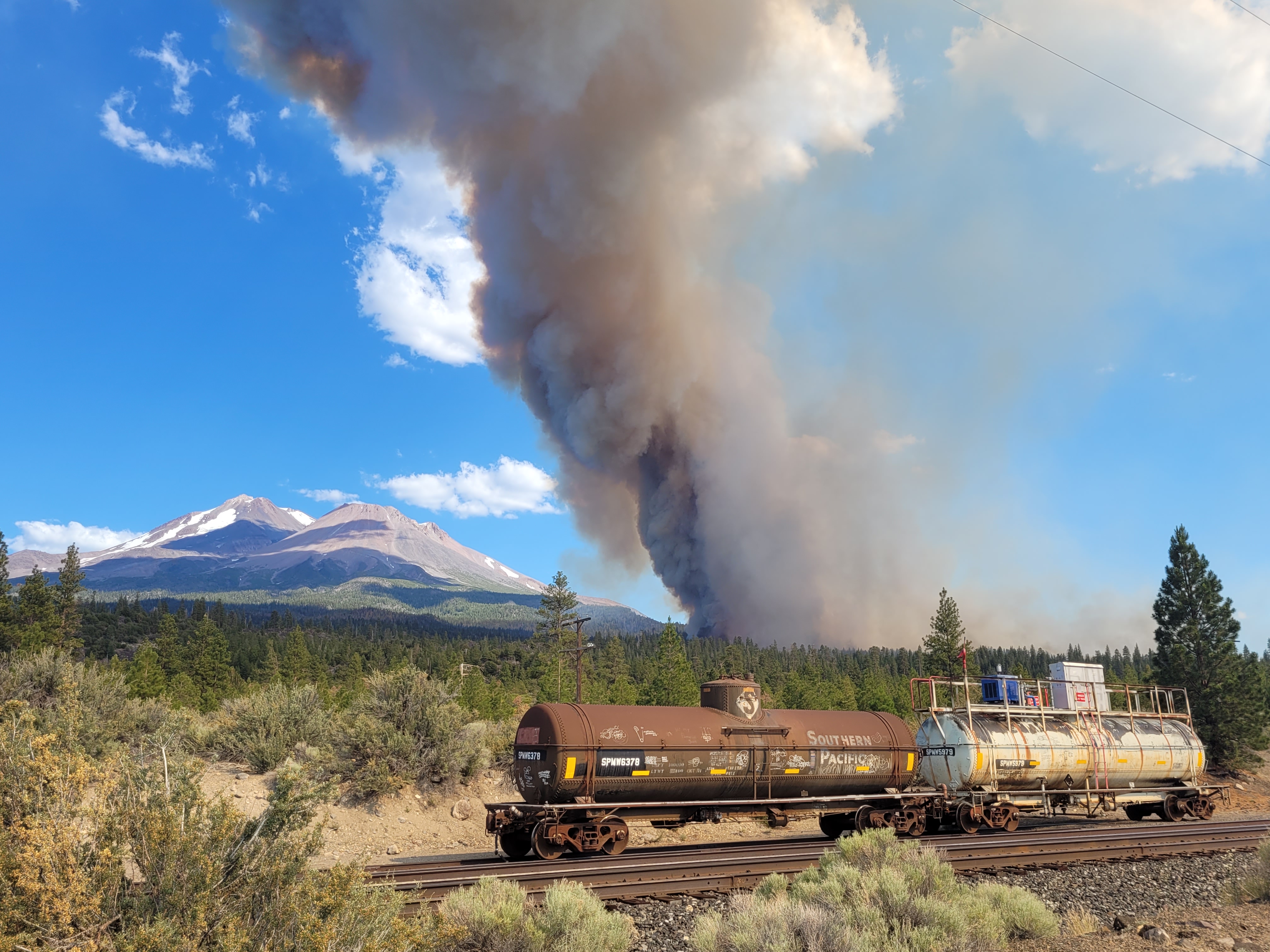
Not good. Just made a hard run north, rotation in the column, constant group tree torching for about the last 20 minutes. Compare the location of the fire in this photo to the previous one. Taken from exactly the same spot.
10 Likes
Wow that’s got an impressive run north yeah. Read they’re pulling crews off the line because of hard push north. You can visibly see the fire spotting ahead of itself as it goes up the Volcano on the local fire cams. Definitely going to be 1,000+acres before long.
Great photograph btw! Thanks for share-- hope you can share more. These are some of the best photos I’ve seen from near the fire.
3 Likes
AA made a great call in giving a heads up to Div A for the fire activity… great call…Div A moving crews to safety areas
all be safe out there
4 Likes
LCES

Great article on LCES:
Remember it’s only late June and burning conditions will increase the risk to suppression crews. Resources are already stretched thin and tactical priorities may change.
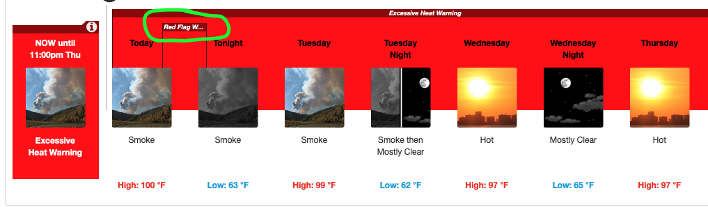
WWA Summary by Location for 41.43N 122.37W with CAZ081/CAC093/CAZ281 emphasis Red Flag Warning
4 Likes
Any idea what their trigger point is for unified command with CF? It’s pretty close to the SRA lines and with the expected growth today…
Thoughts from the sidelines RE: todays forecast, observations and local knowledge
Local knowledge of 3 significant fires have occurred within 2 miles of the current LAVA Inc, all while under a southern flow airmass. All three damaging infrastructure and or structures. One with significant losses. Point being; spread on the Lava for the last 48 hours has truly only been because of slope/fuel and diurnal flows. Todays forecast of low RH and South winds creates a potential for interesting spread and assets at risk. The Lava will be transitioning ( based on southern flow) downslope to the North, from scattered lava flows, boulder fields with scattered Pondo and manzanita… into continuous Manzanita and Juniper. Natural boundaries are limited to the Unions Pacific RR tracks, Highway 97(2 lane), of which the Hotlum Inc compromised by direct flame impingement in February of 2006, Ultimately the brush fields and Juniper are a continuous fuel bed leading directly into the 2 Shasta valley “sub-divisions” of Lake Shastina (population 3000+/-) and Shasta Vista. 2 other points which have both been touched on…
1.Fuel moistures, live and dead are all at or exceeding maximum/minimum recorded and provide for maximum ERC’s.
- The reason Abner Weed and Louisiana-Pacific Lumber built the mill in Weed, is because of the natural drying characteristics of the significant "notch " winds that blow through there regularly. Southern flow winds that are forced up the Sacramento Valley, squeezed into the Sacramento River drainage, ultimately being channeled between the western slope of Mt. Shasta and Eastern Slope of Mt. Eddy prior to spilling into the Shasta Valley via Weed, Ca.
1.Hotlum Incident
Prescribed fire escape, Feb 25 2006, 3000 acres with structure loss
2.Boles Incident
Arson, Sept 2014, 479 acres, 150 Structures lost
- Hoy fire Mid 2000’s,
Electrical failure, Several hundred acres, Minimal strucure loss, Lake Shastina
17 Likes
That’s an excellent summary of the situation! Just one addition to your comments - Shasta Vista may now have a greater population than Lake Shastina. I’ve heard estimates ranging from 4000-5000 people, almost all living in unpermitted shanty’s with no water infrastructure on poorly maintained dirt roads. There are also very limited ingress/egress routes to that community.
6 Likes
That area is pretty spread out, population wise. Lava rock, juniper and light grasses. One of those “why would anyone want to live out here?” areas. Lots of Marijuana grows.
2 Likes
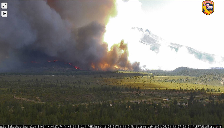
Appears the wind shift is beginning on the 15 minute loop.
2 Likes
I hope they prepped 97 really well and have contingency plans to keep it out of the Lake Shastina area.
1 Like
There has been no prep on 97, nor even the railroad tracks from what I saw yesterday. There have been mastication projects on the Hotlum Road and Big Springs Road that are a few years old and have some regrowth. That’s something to work with, at least…
4 Likes
Anecdotally I can say the fire is showing a lot more heat on satellite than any of the last 3 days. The southerly flow will be driven by the low pressure just west of Cape Mendocino (meaning its not just the typical diurnal influence). When the lid breaks and if the fuels are aligned things should be pretty lined up for all the energy stored in that timber to be released.
2 Likes
Looks like there’s a spot pretty close to 97 that just popped up. Lake Shastina cam.
5 Likes
Thank you for all the information you post. Very helpful!
#LavaFire Siskiyou County warning upgraded to mandatory. If you’re in the area please help your neighbors .
LAVA FIRE EVACUATION ORDER - LAKE SHASTINA AND JUNIPER VALLEY AREAS
THIS HAS BEEN UPGRADED TO AN EVACUATION ORDER.
This is the Siskiyou County Sheriff’s Office with an EVACUATION ORDER due to wildfire for residents on the north side of Hoy Road, North along Highway 97 to County Road A-12, Communities of Lake Shastina and Juniper Valley off Big Springs Road from Highway 97 to McDonald Lane on both east and west sides of Big Springs Road.
THIS IS AN ORDER TO EVACUATE. DON’T WAIT!
A Temporary Evacuation Point (TEP) has been established at Big Springs Elementary School
3 Likes
Does this enter SRA once its crosses 97? It looks like it will hit the highway in the next couple hours at this rate.
4 Likes
Yes, for the most part Hwy 97 is the DPA line, it runs along the tracks from Hotlum to the city limits of Weed.
1 Like
Just heard LNU punch out 9144C to SKU immediate need form up in Redding. Didn’t catch the engine numbers.
2 Likes