Is that UPRR’s main? If the trestle is damaged, North/South rail traffic will be down for a long time!
4 Likes
It appears that way. I know that stretch runs from weed to Klamath falls.
3 Likes
Yeah, that’s the UPRR main line, Black Butte Sub. Quite the hit for freight movement, and Amtrak Coast Starlight. Gonna be a lot of traffic up Feather River Canyon to Keddie Jct, then up the BNSF Gateway line to Klamath Falls instead.
6 Likes
Yes, I believe that is the main line between Dunsmuir and K Falls. The railroad is amazing on getting up and running. Remember when the bridge over the American River burned several years ago in Sac? I think they were up and running within 48 hours. They have prefabbed bridge sections staged all around the western rail system.
9 Likes
UP is already working on it.
8 Likes
You’re correct. I work in Elk Grove and UP was replacing their trestle over the Cosumnes River and the supervisor told us it would take them about 8 hours to cut the old section out and put in the new pre-fabbed section. Time is money, and a lot of it for them.
11 Likes
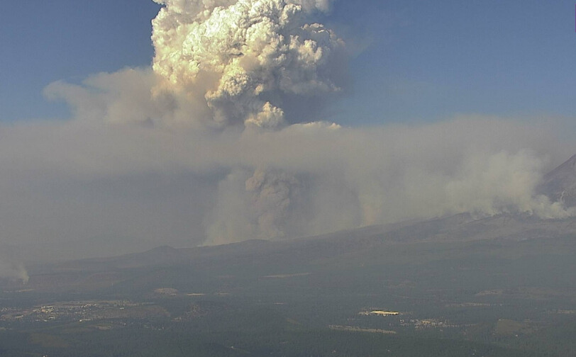
Impressive column growth the last several hours
http://www.alertwildfire.org/shastamodoc/index.html?camera=Axis-HammondRanch&v=fd40729
2 Likes
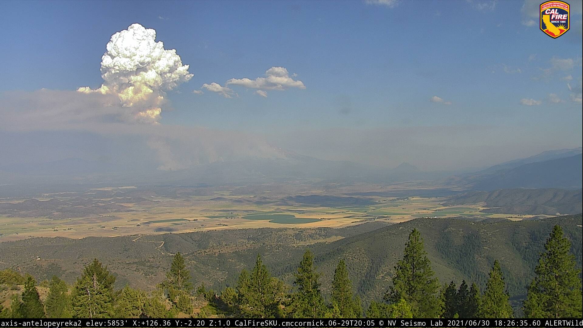
Here is another angle. From 1740 to 1840
http://www.alertwildfire.org/shastamodoc/index.html?camera=Axis-AntelopeYreka2&v=fd40729
2 Likes
Priority traffic just went out on the lava, division delta experiencing a massive column with potential for collapse.
6 Likes
The column seen from Red Bluff (90mi south) is intense, and by far the tallest seen since the incident started.

12 Likes
32min later, no view from Red Bluff. 15min timelapses on many cameras showing significant drop in the column.
Intel from ground:
Cold black on the south side of 97 at County Rd A12. Trying to build a corner east on 97 to Military Pass Rd and firing out from 97 south, may or may not get it done. Weather has been repeating 4 days in a row now. 1500hrs hard push from the south. 1800hrs push from the west. 1900hrs push out of the north. The cheap $1 palm read on this says continued repeats of this pattern could eventually wrap this around the corner and push towards Pilgram Creek on 89. With the new incidents causing significant battle for resources, it’s not out of the question the fight moves to 89 over the next week.
11 Likes
Lava Fire morning update July 1, 2021
Acres burned: 19,680
Containment: 25%
Personnel assigned: 1,23
Weed, CA-- Cooler temperatures contributed to fire crews increasing containment lines on the west side of the fire, continuing to reduce the threat to nearby communities. Afternoon winds caused the fire to flare yesterday in unburned pockets within the interior, east of Highway 97. Fire continues to actively spread to the northeast with short range spotting. Dozers are establishing and improving existing containment lines along the northeast and south side of the fire.
Low afternoon humidity and south winds gusting to 20 mph are expected again through mid-morning with a switch to northwest winds late afternoon. Temperatures are forecasted to be slightly cooler again today. Drought conditions coupled with diurnal winds contribute to fire spread to the north and northeast.
Today, priorities will include building contingency lines on the east side of the fire toward Bolam and Whitney Creeks. Crews will be strengthening containment lines and mopping up the southern and western flanks to protect the communities of Lake Shastina, Mount Shasta Vista, Big Springs, Weed and Mt. Shasta. Evacuation orders remain in place for Lake Shastina, Mount Shasta Vista, and portions of Big Springs. Challenges to firefighters include steep, rocky terrain, limited road access to the fire, and limited water sources near the fire.
The Lava Fire is being managed by California Incident Management Team 14 and is in unified command with CAL FIRE.
EVACUATION AREAS: Mount Shasta Vista Subdivision, Carrick Addition, County Road A-12 north and south, Harry Cash Road, 4 Corners to Hart Road, north side of Hoy Road, North along Highway 97 to County Road A-12, Communities of Lake Shastina and Juniper Valley off Big Springs Road from Highway 97 to McDonald Lane on both east and west sides of Big Springs Road.
Highway 97 is closed between the City of Weed and City of Highway 97
4 Likes
Type 1 team was ordered yesterday afternoon. Sounds like a transition sometime tomorrow or Saturday morning.
4 Likes
Did you hear what team will be ordered? State or federal
Its a Federal Type 1 team. Believe its CIIMT2.
2 Likes
It will be California Team 1 McGowan IC
5 Likes
CIIMT2 went to the Salt and CIIMT 4 is staged at Mcclellan
5 Likes
Recent word is CIIMT1 is going to Lava. CIIMT2 is going to Salt.
3 Likes