Anyone have info on a fire in the Canyon Creek/Globe Mine Road area west of Trinity Lake? From the satellite fire detections, it looks like it might have potential.
1 Like
If it’s in trinity alps, I heard 125 acres (unconfirmed) and might be a managed Fire.
Kymkemp.com has a 9/6 story re: two GFP Enterprises hand crew FFs who were injured on the fire(s) near Canyon Creek. They went in on foot and the article’s info had the fire they were on at ~20 ac.
Here’s the basic fire info from Inciweb. They have a lot on their hands…
Lightning storms moving through the area have ignited several small fires. Forest officials and firefighters closely monitor these storms and use a combination of aerial reconnaissance flights, staffed lookouts, fire prevention patrols, and reports of fire activity from the public in order to respond quickly and determine potential growth activity of the fires and develop appropriate response activity. Reconnaissance flights are part of our normal operating plan after lightning storms.
Below we have listed each fire by the time the fire was reported, the name given to the fire, the approximate location and estimated fire size (if known) and current status. Any large fires will have a new “incident” page started in InciWeb.
South Fork Management Unit (Hayfork and Platina area)
09/05/2019 7:11, LITTLE, Yolla Bolla Wilderness, 0.25 acre, Patrol status
09/05/2019 7:14, FORK, southwest of Platina west of Tedoc, 0.25 acre, staffed
09/05/2019 8:57, LOVE, north of Hayfork near Love Letter Springs, 0.3 acre, crews hiking in
09/05/2019 9:34, NATURAL, near Natural Bridge > CAL FIRE SHU direct protection area
09/05/2019 1:50, SOUTH, SE of Tomhead MTN, 1200 acres
Trinity River Management Unit (Weaverville, Big Bar, Trinity Lake, Trinity Alps)
09/05/2019 7:09, EAST, Halls Gulch NE of Trinity Lake, 0.25 acres, staffed
09/05/2019 7:22, LADY, Lady Gulch Trinity Alps Wilderness, 1 acre, staffed
09/05/2019 7:25, LICK, east of Trinity Lake, unable to locate
09/05/2019 8:16, CEMENT, east of Trinity Lake, unable to locate
09/05/2019 8:18, FOOL, west of Trinity Lake, 0.1 acres, CONTAINED
09/05/2019 8:20, QUARTZ, west of Trinity Lake, unable To locate
09/05/2019 8:23, SLATE, west of Trinity Lake, 2 acres, CONTAINED
09/05/2019 9:07, MIDDLE, NE of Canyon Creek Trailhead, 20 acres, staffed
09/05/2019 10:13, EASTMAN, south of Tunnel Rock .25 acres, CONTAINED
09/05/2019 10:38, WAGNER, Billy’s Peak west of Trinity Lake, 0.1 acres, staffed
09/05/2019 10:44, HATCHET, east of Poison Canyon .5 acres, CONTAINED
09/05/2019 11;15, JAKES, Jakes Upper Camp, 0.1 acres, staffed
09/05/2019 12:18, RANCH, located above Rancheria Creek, 0.2 acres, CONTAINED
09/05/2019 12:56, CUTTHROAT, west of Cutthroat Gulch, 15 acres staffed
09/05/2019 2:29, IRISH, Jackass Springs, 0.1 acres, CONTAINED
09/05/2019 2:53, SWIFT, NW of Trinity Center, CONTAINED
09/05/2019 4:50, HOBEL, SW of Trinity Center
09/05/2019 5:39, RAMSHORN, Ramshorn Creek north of Bonanza King Mtn., 0.1 acres
09/06/2019 10:14, HORSESHOE, Horseshoe Lake, 0.1 acres
09/06/2019 12:34, LAKE, Toad Lake, 0.1 acres
1 Like
Thanks, looks like it is the Middle Fire. I’m guessing it has grown significantly since that report, since it’s satellite signature is larger than the Ramshorn, which was last updated at 70 acres.
1 Like
Knowing that terrain, I would agree. I think the Inciweb info is a few days old. Let’s hope the NWS forecast is accurate, it should help.
1 Like
One of those or this canyon creek has been showing for days on the hayfork alert cam:
http://www.alertwildfire.org/shastamodoc/index.html
Kymkemp.com has video from the USCG helo crew who lifted the injured FF out. Kind of disorienting (been on that end and it is…), but there are some images of the fire. showing what they have on their hands.
1 Like
If you are a firefighter, do not show this to your mother!
2 Likes
Per the IR flight last night, Middle is 223 acres, Ramshorn is 266, and Cutthroat is 18.
1 Like
I was a ground and flight paramedic. All my fire work was on the ground. Nothing like spinning under a helo during the day…cant imagine it at night.
That was one hell of job by the Coast Guard. Check out the story on Wildfire Today.
1 Like
SHF-South Fire 3,185 acres, 20% contained. The incident is located in steep, rugged terrain. There is a structure threat to rural private residences and ranches, as well as Tomhead Lookout and communications infrastructure. There is also a threat to prehistoric trails snf historic sites. Fire may impact a Class 1 Airshed within the Yolla Bolla Wilderness.
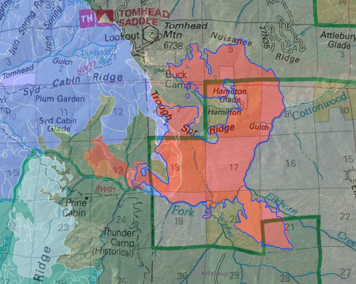
For the south fire, latest IR, with Tuesday’s IR outlined in blue to show yesterday’s progression. Blue shaded with white outlines is 2008 lightning complex footprint, including the Iron, Slides, Vinegar and Harvey fires. The south fire blew a good 250 acres west into receptive fuels outside of Iron’s footprint and popped a column that capped twice yesterday. Today is hotter and drier.
Some great structure defense around the cabins yesterday in Buck Camp area. Lots of type 1 rotor support, with Natl Guard shuttling in 24hr resources every morning, then throwing buckets on in the afternoon and, while not as precise as the commercial type 1s, slinging water on the fire.
6 Likes
Looks like a little north wind on it. Anyone know if that some interior burning or are they having some issues?
They started a firing op about noon today. Starting at DP130 down the road east to Buck Camp area and west along the handline to the trail along Syd Cabin Ridge.
South fire exclusive on scancal.org/live.html scanner. CDF Cmd7 (calfire ops and air command), Air Tactics, Air Ground, rotor victor and briefing, and a NIFC command repeater for USFS ops.

2 Likes
Copy, Thanks.
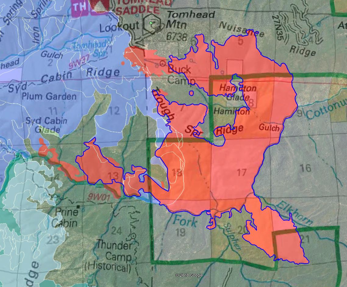
South Fire Friday morning. The entire east side of the fire is done and mop up and suppression repairs start with chipping debris piles etc. Up around the top along Nuisance Ridge they’ll reinforce the lines in any areas of concern, and where it’s cold they’ll mop up deeper into the black.
Coming around to Buck Camp - they had a successful firing op yesterday from the intersection of 27N06 and the lookout road, down 27N06 and along the S curves into Buck Camp area. That’s going to be a huge sigh of relief for the bulk of the cabin owners up there. With good fire all around cleaning up the forest floor and brush, 99% of the risk is gone for those cabins now. They will continue firing off in the other direction today, west along the hand trail over to Syd Cabin Ridge. The fuels are very receptive as seen from yesterday, so it will be hot and heavy again today. This also means if anything gets across the line, it’ll be running hard.
Contingency line will be built along the 27N06 road up to Tomhead Saddle, and then they will continue scouting and potentially reopening the old containment line from the 2008 Iron Fire to the northwest along the Humboldt trail and wilderness boundary over to East Low Gap.
Coming around to the SW corner, the fire continues to spread west, across the drainages right along the SFrk Cottonwood Creek. This behavior is coming from the hot and dry air coming up the creek from the Sac Valley. Staying low along the creek with the lower RH and higher temps. If it finds the right moment, it can blow north up any of the drainages it crossed, terrain/fuel driven, up to Syd Cabin Ridge. Their goal is keeping this fire north of the creek. Scouting trail and road systems of where they’re going to eventually try and hook this piece.
Calfire is releasing all the aircraft assigned to the Red Bank Fire, and the forest is keeping a few Type 1 copters for the South. Also, per the Air Ops Branch Director, there will be no helicopter support available today for the entire west side, along the Syd Cabin Ridge firing ops or down in the fire spread along the creek. Unknown why this arbitrary decision was just made. At least the cabins are in good shape before that occurred.
Map same as before, red shade is last night’s IR perimeter. The blue outline is Wednesday night’s IR to show progression in the last 24hrs. Blue shading is the 2008 lightning complex fire scar (Iron Fire etc.)
5 Likes
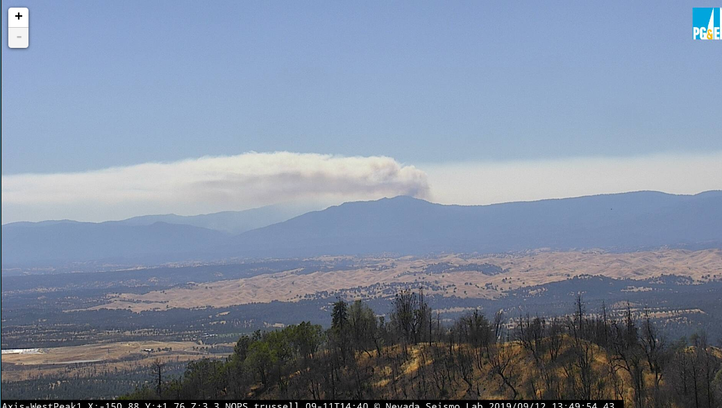
From the looks of the column coming up from Trinity county, I would guess the FS lost the Middle fire today. Partly visible on the Hayfork camera. South Fork has a great shot of it.
2 Likes