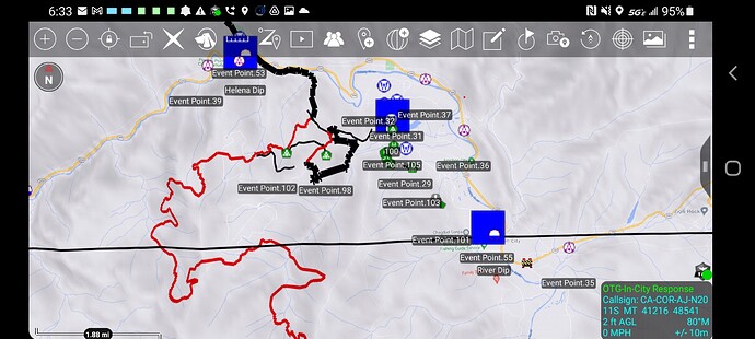
data package is up for the monument - maps.takserver.us
36,015 acres and is still 0% contained.
Some structures lost in Big Flat.
data package posted for. the monument maps.takserver.us
data package is up for this incident - maps.takserver.us
Well I cant reply 3 times in a row apparently but I can edit my post So today is August 10th and a data package is up for the monument - maps.takserver.us
Thank you for all the hard work AJ!!!
DATA package is up maps.takerver.us
Fixed the address… maps.takserver.us
Thanks, AJ
data package is up - maps.takserver.us
data package posted for the monument. maps.takserver.us
74,759 acres and 5% contained
data package posted for the monument - maps.takserver.us
data package posted for this incident - maps.takserver.us
New item - The GIS exported the event line-point-polygons as separate KMZs this is cool for visualization in programs like Google Earth.
I mashed them into one KMZ and its in the data package and renders in ATAK or GE.
The cool thing about it in ATAK is you can search for items so if your looking for Drop Point 53 if you search 53 it will list all items with 53 in it. You can filter by extent. I am going to try and see if the devs will bring in the ability to render the point icon in the filter list.
Just another cool way to share data.
Some of the drop point marker scale is much larger than the other drop points so kind of looks weird.
The fire made a run up Ironside Mt. this afternoon and Ironside Lookout was lost. Also the southeast side of the fire is being tested by the northwest flow. Reports of multiple spot fires over Soldier Creek Rd. in Div. X. This one has kind of been off the radar with with Dixie Fire, but it as a lot of potential.
Yes, the Dixie Fire seems to be getting the media attention. I haven’t been able to get much on these fires. With the expected winds, what is the threat to more communities looking like? Given the sheer size of the Dixie Fire, plus other fires, I can’t imagine there being much in the way of resources left to put in the fight.
maps won’t open, neither will pdf maps. for me…
data package posted for the monument - maps.takserver.us
Try this one

