Off to the races
Anything to stop the lateral progression of the fire towards the camera? Flank has moved that way quite a bit.
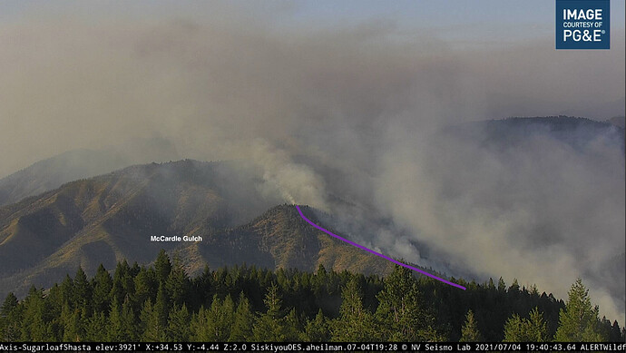
Interstate 5 is at the near the bottom of a canyon in between the fire and the camera. You can see that from the map that shows where the camera is.
Thanks that helps. Was trying to figure out how far away it was
It definitely just blew through the Campbell Creek bowl, where Fenders Ferry Road starts off I5, along with the old Dog Creek Bridge. It wasn’t quite area ignition but it was dang close, the bulk of the downslope and back up the other side in a matter of 10 minutes. That ignition made column ice cap at 1606, went up another 2-3k feet at least, and then collapsed 1617. Take a look at the Sugarloaf cam timelapse and what the fire does at those times.
Air Attack is waiting for it to clear out up there and then will give an assessment. Delta scar starts on the north side of Fenders Ferry Rd. Still lots of green between this and the river/freeway/railroad, especially along the flanks. Copters and scoopers have been keeping the flank in check as it approaches the freeway and railroad.
There’s some large areas on this mountain (Delta Point) that went scorched earth in the Delta fire. Still some bare earth today, others took back brush (old dozer lines disappeared.) It’ll be interesting to see how the winds and terrain are in the fire’s favor, but it might have to look harder for fuel.
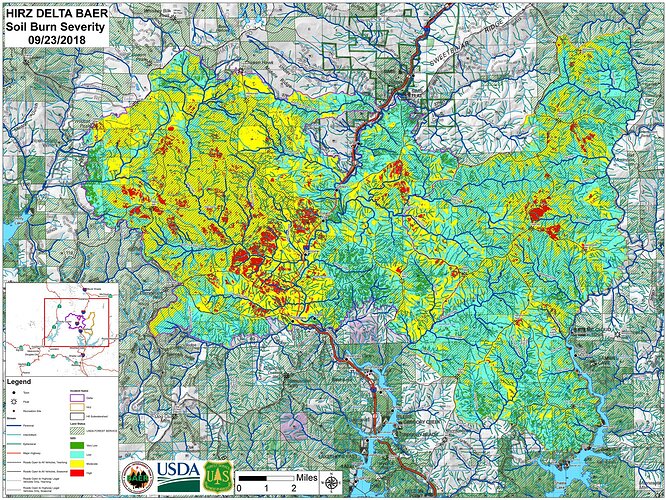
Edit: going back to some BAER reports on the Delta/Hirz, while there definitely is some scorched earth below Delta Point and the left shoulder of this thing (can see from I5), as well as the right shoulder going up Middle Salt Creek, straight ahead where the head of this is going, Crane Mtn and the east-west ridge between Delta Point and Crane, took very low intensity flames in 2018. Sat view shows plenty of timber in the area. There are 2018 dozer lines on the ridges off Crane and Delta Point, but not sure if they got those opened back up or not. Talk of trying to paint them, but the column is making it sketchy for fixed wing. T1 copters working the finger going up Crane Mtn keeping it a slowed down.
1800: Air attack reporting much lower intensity fire since he’s been up.
Here is a combined soil burn severity for the Delta and the Hirz. I remember at the time thinking what a beneficial burn the Hirz was. Delta not so much.
Seems like Hirz is going to have a lot of interior fuel to burn.
Ps. Newbie. Hopefully posted correctly.
That’s some of the data I was using. Head of fire just below dead center, in the Campbell Creek watershed. This is the lighter-intensity piece of Delta where you can see the blue/green vs the massive yellow and red, where reality today still has bare earth or black sticks. The fire instantly slowed in intensity tonight there above Fenders Ferry where it enters Delta burn.
Looking at some current intel, the left flank of the fire hasn’t even made it to the river all along Div M, Pollock and Riverview. As the fire travels due north, it gets further from the river, railroad and I5 (and Delta. Adding on to my IA sketch map, the purple line is roughly the left flank/shoulder line as of 1900. Scoopers were dropping along that flank to keep it in check as it slowly backed/creeped down into the river canyon. But if you know Dog Creek Bridge, the flank is a bit further up in the canyon than you can tell from the Sugarloaf camera. It jogs sharply right off a spur ridge from Delta Point. The upper piece of the purple line on the map I cross-referenced to the camera shot below.
Sentinel satellite imagery is good for evaluating burn severity from recent fires, and also, seeing where salvage has been completed. The bird goes over every couple of days, and turnaround on the imagery is very fast. So it can be good for seeing where the fire actually is. Last year we were able to support operational planning on several large fires using this imagery. Try different display options to see IR, etc. Sentinel Hub EO Browser
Note, on a phone, you may need to close the (upper right) menu to see the imagery…


