And now back to the fire!!!
Does anyone know if the spots West of I5 and north of the Sac arm got picked up last night/ this morning?
I read that they did
All spots west of 5 and the lake were picked up. Evacuations in effect for delta school road.
Salt Fire A…M. Update 7/01/21
Redding, CA -The Salt Fire is approximately 2,800 acres and 0% contained. The fire remained active overnight, fire personnel worked at keeping the fire east of Interstate 5, putting line in along the highway on the southernmost point of the fire before the winds shifted. Firefighters also provided point structure protection for residences in the fire areas. There were a few spot fires along the west side of Interstate 5, firefighters took action and were able to contain the spot fires before they could get big. A type 1 incident management team has been ordered and are in
Will that be a state or fed IMT?
Federal. I think it was CIMT2
Thank you.
Unsure if their assigned to the salt but just passed a line of LPF and ANF type 3s entering Shasta County NB on I5
CIMT1 was on Hard Cover in SAC. Be interesting to see who gets it
Jackson hotshots out of Mississippi rolling north on I5 through Colusa County.
CIIMT 1 to the Lava…CIIMT 2 to the Salt
Apologies to the mods.
Meant to put this video here instead on Continuing Fire and Incidents for the Salt.
Initial Burning Hours from Sugarloaf Cam
That’s actually a powerful site to see.
I just caught tanker 914 direct from PHX, 180 turn over the fire and then back toward MCC. I suppose they must have made a drop, that must have been a long flight to make 1 drop and then I guess prepo for the morning.
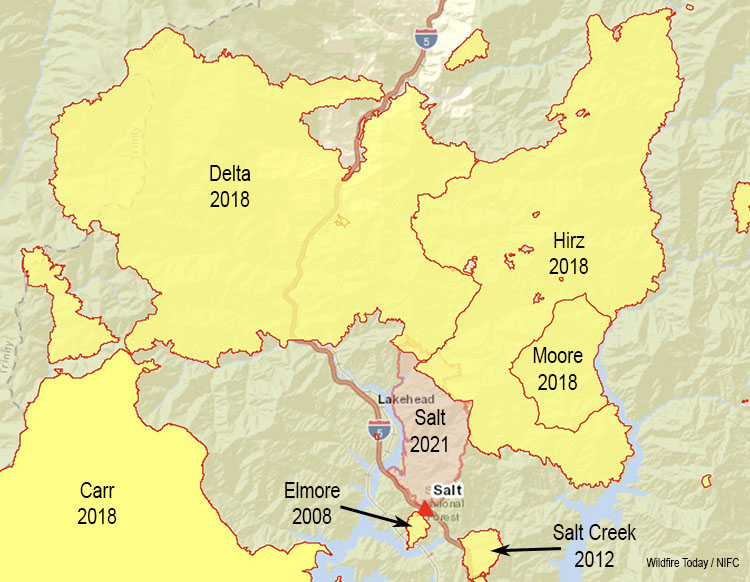
Nice map from Wildfire Today showing recent fires around this one. This morning’s IR showed the fire pushing about a mile north into Hirz burn with upcanyon push.
XSU demobed from Lava headed to Salt
Is the norcal scanner sending alpha-tag info still? Not seeing it when playing in Winamp. Have been using it to monitor the fire, thank you!
It should be, it was Friday. It’s been a while since a reboot so I’ll reboot it when the aircraft bed down tonight. I have Salt A/G on priority, Salt Cmd, SHF Forest Net and its UHF link which brings in some Lava aircraft logistics as well. Since it’s not fully “ripping” I still have TGU/SHU local nets on higher priority, but still a decent amount of traffic.
Unless something big blows up in TGU/SHU, I’ll keep it focused on SHF-Salt this weekend.
From the time lapse, looks like it had a good south wind on it last night and it burned actively all night. Looks to be most active on the ridge south of Campbell Creek, south of the Delta fire scar. Appears to be taking a little breather this morning, but still putting up a column.
Hopefully it slows down when it gets to the Delta.


