Public just tweeted that Carr Fire has crossed over east side of hwy 5 at Oasis Rd. in Northern Redding.
1 Like
No fire anywhere near I-5
1 Like
http://www.arcgis.com/apps/webappviewer/index.html?id=38af98f710d94937a61eb0789211de54&find=1350%20Buenaventura%20Blvd%2C%20Redding%2C%20CA%2096001
Thank You Paul Doherty @pjdohertygis for this update.
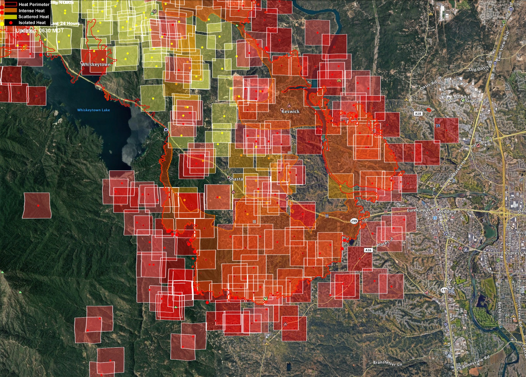
Just got back from Redding. No high schools have burned or even close to any high school. Shasta High across the river from the large arealf structure fires. No fire anywhere close to 5. Shasta Lake City no power. Fire is creeping towards upper sac river canyon above Keswick, visible from dam overlook areas. Mary Lake area feels like a pretty dirty burn so lots hot spots still and structures.
13 Likes
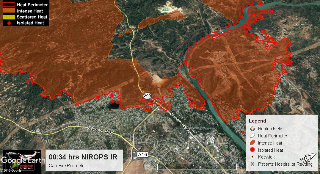
IR flown at 0034 MDT:
4 Likes
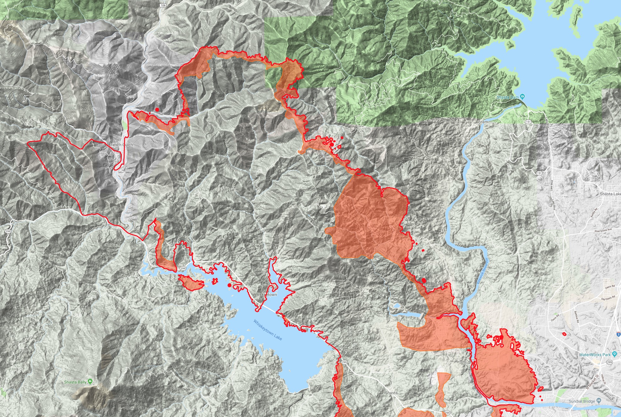
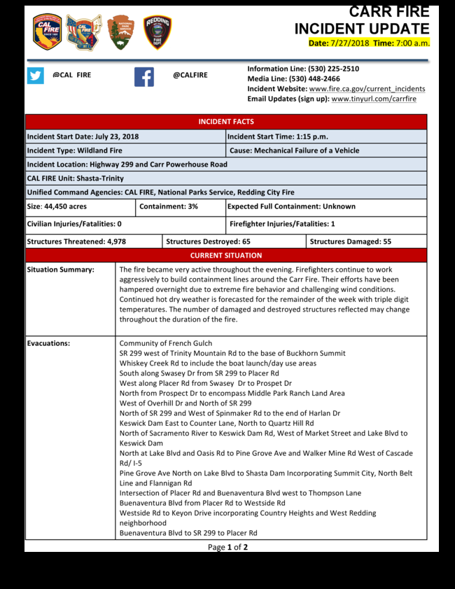
44,450 acres and 3% containment
1 Like
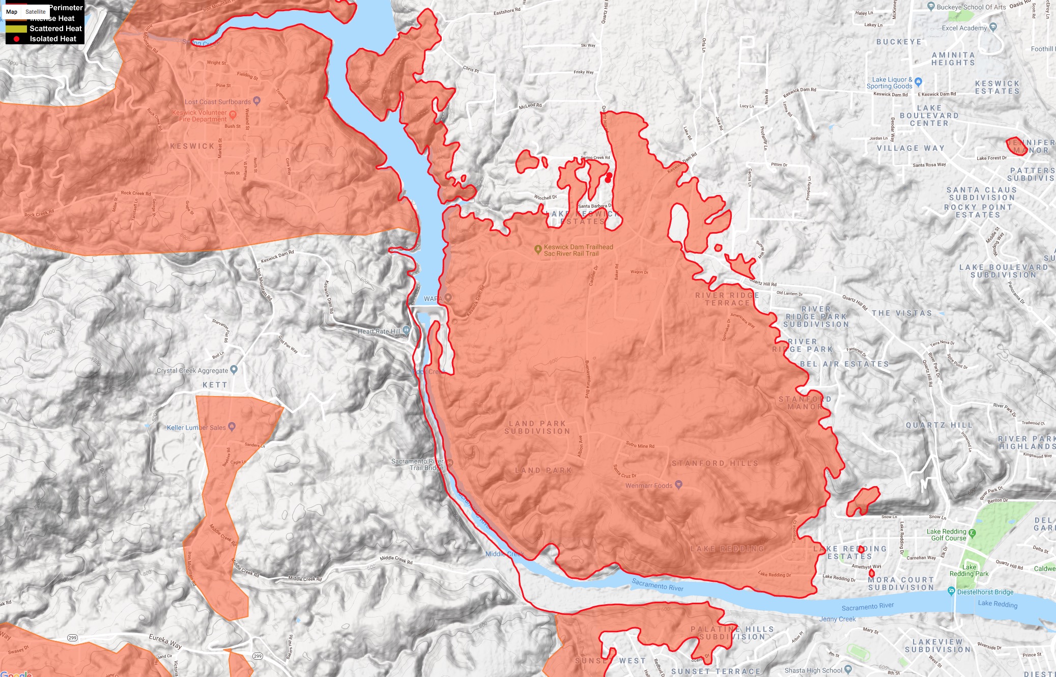
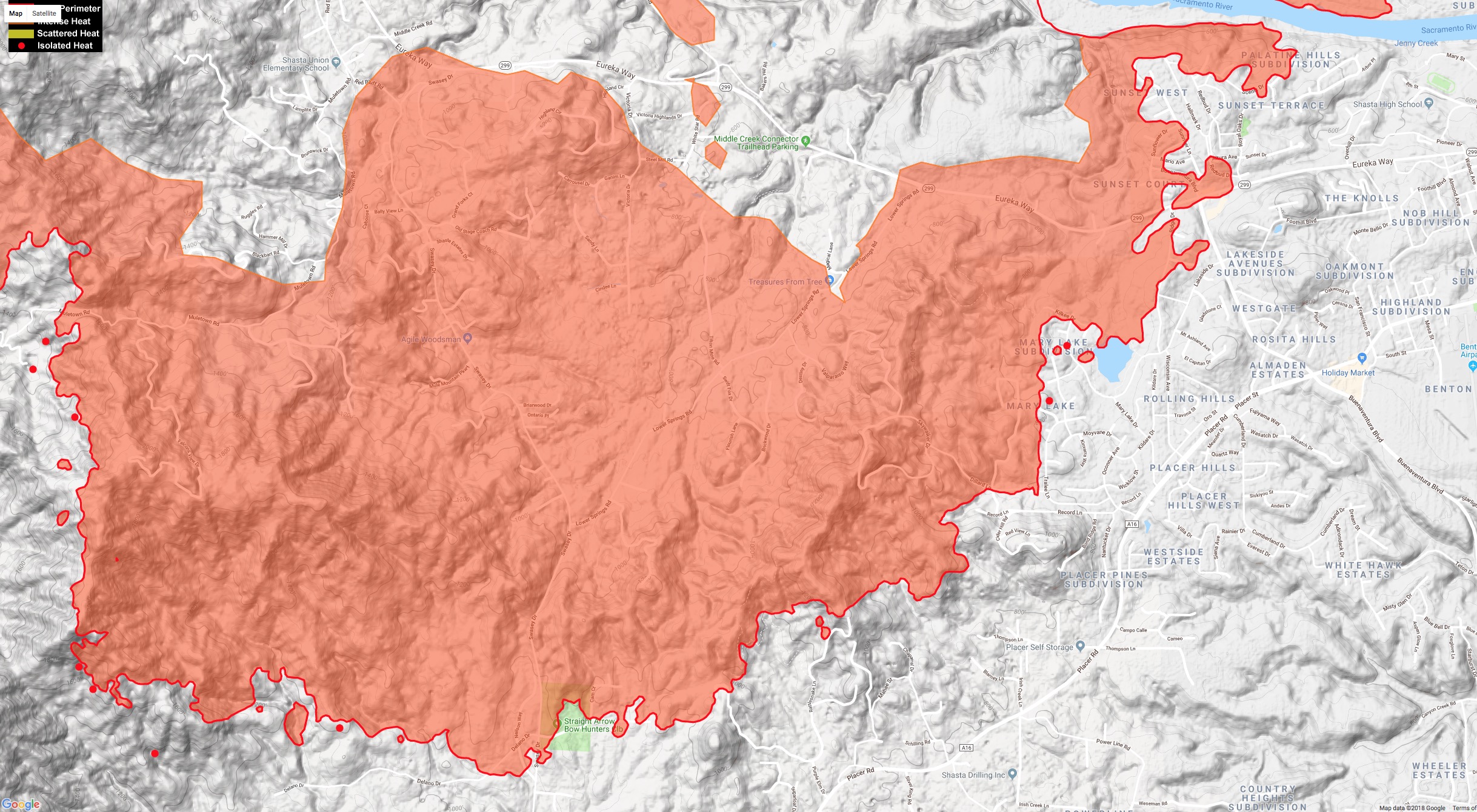
Here’s another look at the leading edge of the Carr Fire in West Redding using last night’s NIROPS IR. Please note: Not all homes in the red are gone. My friends home was on Victoria Drive inside the fire perimeter, but the grass fuels burned through so fast, that the home didn’t catch, or a patrolling engine was able to spray a bit of water on the burning edge of the deck and move on. I also have intel, confirmed by this map that Shasta Elementary is still standing, but with two hospitals evacuated and this much extension of fire into densely arranged homes, there have to be more homes lost than the current official tally of 15.
2 Likes
2 Likes
Spot Weather Forecast for today
https://www.weather.gov/spot/php/forecast.php?snumunum=1813497.0&lat=40.63759827779259&lon=-122.563343509678&z=11
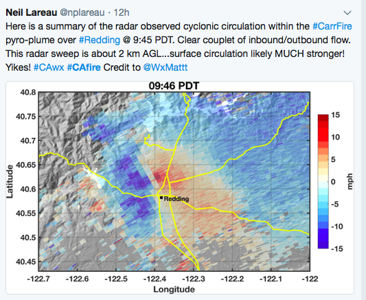
I found this interesting, it shows the cyclonic circulation that occurred in the plume over Redding. This is why the fire behavior was so extreme.
From Twitter: Neil Lareau
8 Likes
Just finishing some field work on the support side of the fire and getting back to the office. They brought online a significant number of NIFC command repeaters the last day or so and day ops is working them today. However still plenty of traffic on cdf command 2. Not fully transitioned. Live scanner has cmd2 on highest priority, and some of the NIFC cmd’s in regular scan. I’ll stick one on priority tonight when I get home.
Helibase rapidly moved from Mountain Gate to Airport last night after pumpkin for fear of fire spread in the worse case. Moved this morning out to the old Sky Ranch near Win River Casino.
Fire in the valley has progressed significantly to the south in and around Placer at Swasey, and Centerville area. Was low intensity this morning but will be huge concern this afternoon. The punched the evacs for Igo area, lots of hard closures going in to the area to support evacs leaving. CHP dealing with hostile runs through some of the closures.
Not sure what fire is doing around the lake, other than when AA went up late morning she said it was still on the lake side and influenced by winds with the lake, but expects that to change when it heats up. Haven’t paid attention to anything up on Div O/M and Trinity Mtn Rd and East Fork. It was supposed to get impacted last night.
13 Likes
Neil is a professor at San Jose State who with this colleague Craig Clements are working hard to understand local and synoptic wind influences on fire behavior. They are good people.
5 Likes
Thanks for all your efforts. Best incident intel by far
4 Likes
1830: And here we are again with the beast starting to transition and get moving. Just a little update - been busy and scattered all day.
Southeastern front is still Placer Rd near Texas Springs, Centerville area. Heavy hitting with copters all day.
On the north end, Div M, it’s now spotted on the west side of Trinity mtn Road at East Fork Road. The spot is 75 acres and moving.
Southwestern new front from the spot from last night at Carr Powerhouse, pretty established. At 1451 AA mentioned to ops that the Shasta Bally repeater site will be impacted at some time, best to start a plan for that. Fire is now at the northern base of Bally. This is a significant radio site for the area, more prominent than the Southfork site that burned a few nights ago, and for some systems, a redundancy to Southfork. TV 7 and 9 are up there, along with numerous FM broadcast.
(this piece is speculative) I believe fire has made it into the upper clear creek drainage but not positive. MODIS/VIIRS says yes. That would put the fire in direct alignment with any northerly winds to drive right into Igo area.
15 Likes