This is east of oak run off oak fern Rd.
http://www.alertwildfire.org/shastamodoc/index.html?camera=Axis-BearMtnShasta&v=7a7f1c3
The 2-2 fire is now waking up.
Round Mtn Shasta Cam:
http://www.alertwildfire.org/shastamodoc/index.html?camera=Axis-RoundMtnShasta&v=7a7f1c3
High line Trail has it as well and a few other smokes popping up:
http://www.alertwildfire.org/shastamodoc/index.html?camera=Axis-HighlineTrail&v=7a7f1c3
1 Like
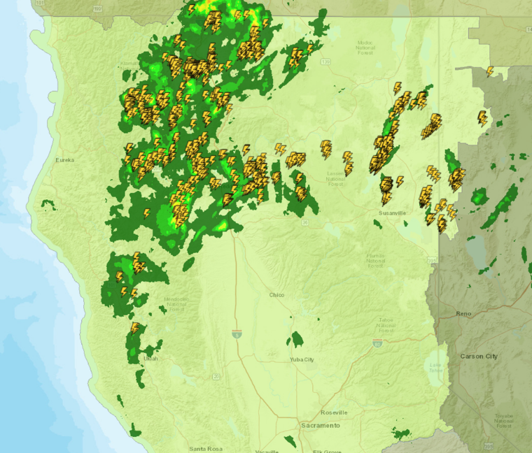
Looks like a pretty steady breeze on it. Did they get rain with the lightning in this area?
10:10 update, 1.39 acres
2 Likes
2 new fires.
2-?
Oak run- donkey mine Rd
Reported by recon ship. 1/10th acre w road access.
Mill inc- shingletown ,Ritz mill Rd
Aa-230 on scene, 2 acres timber mros. High dispatch + 9140c
http://www.alertwildfire.org/shastamodoc/index.html?camera=Axis-RoundMtnShasta
1409- 2 addl type 1 AT
1419 3 AC. Short range spotting per AA
2 Likes
Donkey mine area
2-3 inc
1 acre heavy brush
Augment with addl 2 engines, 2 crews and dozer
Hike in show.
2 Likes
5-1 rainbow lake area
Crew 24A
1/2 ac. Heavy brush
2 Likes
I’m not sure which fire this cam is looking at…
Looks like TGU in the hwy 36 corridor.
Mill inc- holding 5-10 ac. With retardant
1 Like
Camera cross from Round Mtn and Bear Mtn webcams puts the Donkey Mine Fire (2-3?) here:
https://goo.gl/maps/y6Beh3dN4gNYsSJj9
It looks pretty done as of 15:20.
The Bear Mtn cam is showing a fire still cooking farther east, out toward Lassen, but no other cameras are showing it for a cross.
http://www.alertwildfire.org/shastamodoc/index.html?camera=Axis-BearMtnShasta
1 Like
New starts in the Fall River area, multiple smokes being reported. Black MTN area.
3 Likes